
Nature-based solutions for stormwater management in the Helsinki Metropolitan Area, Finland – Prerequisites and good practices
Information
Helsinki Region Environmental Services Authority
30.12.2021
Nature-based solutions for stormwater management in the Helsinki Metropolitan Area, Finland – Prerequisites and good practices
Helsinki Region Environmental Services Authority
P.O. BOX 100
00066 HSY
Tel +358 9 1561 2110
Faksi 09 1561 2011
www.hsy.fi
Author: Niina Kautto
Further information:
Maaria Parry, maaria.parry@hsy.fi
Cover photo: HSY/ Mikko Käkelä
Abstract
Tiivistelmä (in Finnish)
Kaupunkien rakentuminen ja täydentyminen johtaa päällystetyn maanpinnan määrän lisääntymiseen, mikä puolestaan muuttaa veden luonnollista kiertoa. Veteen liittyvien haasteiden odotetaan kasvavan ilmaston muuttuessa, kun vuosittaiset sademäärät sekä yksittäisten sateiden voimakkuus kasvavat. Kaupungeissa haasteet liittyvät huleveteen, eli sade- tai sulamisveteen, joka kerääntyy maanpinnalle ja rakennusten katoille. Suurin osa hulevesien hallintaan liittyvästä kaupunkien infrastruktuurista on rakennettu olosuhteisiin, jotka eivät vastaa tulevaisuuden ilmasto-olosuhteita. Tämän vuoksi huleveden hallinnan järjestelmiä täytyy kehittää. Veden luonnollista kiertoa tukevat ja ekosysteemipalveluita hyödyntävät lähestymistavat ovat yleistymässä. Niitä voidaan kutsua termillä luontopohjaiset ratkaisut.
Tämän raportin tarkoituksena on tunnistaa toimivia luontopohjaisia hulevesien hallinnan ratkaisuja ja käytäntöjä pääkaupunkiseudulla, johon kuuluvat Helsingin, Espoon, Vantaan ja Kauniaisten kaupungit. Raportti perustuu kirjallisuuskatsaukseen, kaupunkien edustajien haastatteluihin sekä tutkimuksen perusteella valikoitujen kohteiden esittelyyn. Työ on tehty osana RAINMAN – Towards higher adaptive capacity in urban water management -projektia (2019-2021). Projektin tavoitteena oli vahvistaa kaupunkien ja kuntien mahdollisuuksia sopeutua ilmastonmuutoksen vaikutuksiin, kuten lisääntyneisiin hulevesien määriin kaupunkialueilla. Hulevesien luontopohjaisia hallintaratkaisuja etsittiin RAINMAN-projektissa määritetyille erityyppisille kaupunkialueille: puistomaisille alueille, uudisrakennusalueille, tiheästi rakennetuille alueille sekä historiallisten kaupunkikeskusten alueille. Viimeksi mainituilta, joita pääkaupunkiseudulla edustaa vain Helsingin ydinkeskustan alue, ei löydetty esille nostettavia ratkaisuja.
Raportissa on katsaus luontopohjaisten hulevesien hallinnan ratkaisujen määritelmiin, tyyppeihin ja niistä saataviin hyötyihin sekä pääkaupunkiseudulla että muualla maailmassa. Raportissa käsitellään myös kohteiden seurantaan ja kunnossapitoon liittyviä näkökulmia kahdeksan kohde-esittelyn avulla sekä esitetään luontopohjaisten hulevesien hallinnan ratkaisuja edistäviä ja hidastavia tekijöitä. Siten raportissa tarkastellaan sekä luontopohjaisia ratkaisuja että kaupunkien edellytyksiä toteuttaa näitä ratkaisuja.
Hulevesien luontopohjainen (tai luonnonmukainen) hallinta on pitkälti vakiintunut kansallisen lainsäädännön ja kaupunkitason hulevesiohjelmien myötä. Kaupunkien hulevesityöryhmät ovat tietoisia luontopohjaisista ratkaisuista, ja ryhmillä on tärkeä rooli näiden ratkaisujen edistämisessä.
Hulevesien hallinnan ratkaisut pääkaupunkiseudun kaupungeissa ovat usein hybridiratkaisuja eli yhdistävät ns. vihreää ja harmaata infrastruktuuria. Ratkaisuilla voi olla hulevesien määrän ja laadun hallinnan lisäksi muitakin hyötyjä, kuten luonnon monimuotoisuuden tukemiseen, virkistysarvojen lisäämiseen ja lämpösaarekeilmiön vähentämiseen liittyviä ominaisuuksia. Näitä hyötyjä ei kuitenkaan ole useimmiten systemaattisesti tunnistettu tai seurattu. Tämä vaikeuttaa luontopohjaisten ratkaisujen vaikutusten arviointia, joka edesauttaa tutkimustietoon perustuvaa maankäytön suunnittelua ja päätöksentekoa.
Tämän raportin on tarkoitus tukea luontopohjaisten hulevesien hallinnan ratkaisujen käyttöönottoa erityisesti RAINMAN-hankkeessa edustetuissa kaupungeissa, mutta myös muut kaupungit ja alueet voivat hyödyntää tuloksia osana omaa hulevesien luontopohjaisten hallintaratkaisujen kehittämistään.
Preface
This report work was carried out as part of the project titled RAINMAN – Towards higher adaptive capacity in urban water management. The RAINMAN project aimed to provide new tools and methods to avoid sewage system overloads, to prevent urban flooding and to preserve freshwater resources. The project intended to integrate developed solutions into city development guidelines and plans to maintain freshwater resources in a good state, despite a changing climate and intensified land use. Furthermore, the RAINMAN project aimed to enhance the capacity of cities and municipalities to cope with climate change impacts such as increasing stormwater volumes especially within urbanised areas with high impermeable artificial surfaces (soil sealing), increasing extreme rain events within urbanised areas with combined sewage systems, and changing recharge patterns of groundwater reservoirs (aquifers) located in close vicinity of built-up areas. Cross-border cooperation can serve as a platform to share experiences and best practices to tackle changing climatic conditions in urban water management around the Baltic Sea Region.
The project consortium included municipalities and research organisations from St. Petersburg and from the regions of South-Savo, Päijät-Häme and Uusimaa in Finland. The project partners were the Geological Survey of Finland (GTK), State Unitary Enterprise “Vodokanal of St. Petersburg” (Vodokanal), the Russian State Hydrological Institute (SHI), the Voeikov Main Geophysical Observatory (MGO), the Helsinki Region Environmental Services Authority (HSY), the City of Lahti, and the City of Mikkeli.
The project was funded by the CBC 2014-2020 cross-border programme with the financing from the European Union, the Russian Federation and the Republic of Finland. The project was active from 2019 to 2021.
The final report of the project will be published on the RAINMAN website.

Introduction
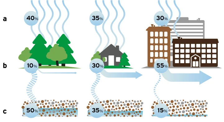
Today more than half of the world’s population lives in cities, and in 2050, the share of urban population is estimated to be almost 70% (Ritchie and Roser 2018). Urbanisation and dense cities lead to a lot of built, impermeable surfaces that strongly affect and change the natural cycle of water. A study of nine cities in the United States showed that the portion of land covered by impervious surfaces grows proportionally with the city growth (USGS cited in Malakoff et al. 2016). The frequency and intensity of heavy rainfall events have likely increased for instance in Europe (McSweeney 2021), and water-related hazards are expected to intensify along with climate change (OECD 2020). These are expected to exacerbate problems stemming from disturbing the natural hydrological cycle. One of them is stormwater, or urban runoff, i.e. rainwater or meltwater that is accumulated on soil surfaces, roofs of buildings and other similar surfaces in built areas. This differs from natural runoff that is runoff of water from unbuilt areas; stormwater is therefore characterised by the impact of human activities (City of Helsinki 2018, Ministry of Agriculture and Forestry 2001). Figure 1 shows how the impermeable surfaces affect the forming of stormwater.
Most of the urban stormwater management infrastructure existing in developed cities in Europe are based on the modern urban sewer systems built in the second half of the 19th century (Bertrand-Krajewski 2021). These systems have also been developed in climatic conditions that are different from today’s, calling for more climate resilient systems. Stormwater has traditionally been managed in urban areas with grey infrastructure, including directing the water as fast as possible away from paved surfaces through underground pipes into sewers and receiving waters. The drainage systems are not generally designed for heavy rainfall or cloudburst events. Therefore, flooding may occur and cause damage to buildings and other property.
In addition to the increased amounts of stormwater needing to be handled, also the quality has gained growing interest. Along with increasing urbanisation and impermeable surfaces, the quality of stormwater is worsening. While stormwater is generally not considered to include harmful substances in quantities that would cause actual environmental or health harm (compared to wastewater), there can still be risk factors like nutrients, solid matter, chemical residues and microplastics that can cause harm if they end up in waterways or soil (Gustafsson 2021).
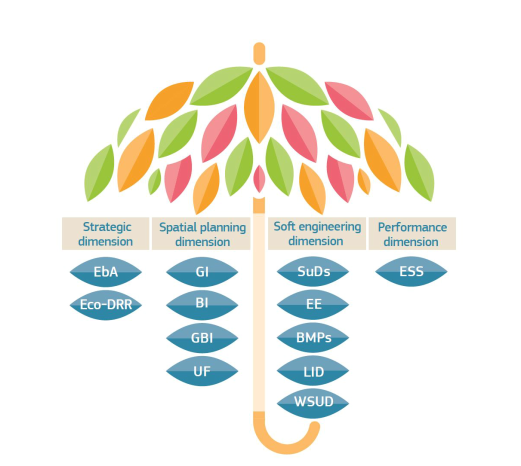
Increasingly, integrated approaches to urban water management – that correct or mimic the natural cycle of water and utilise ecosystems’ functions – are emerging. These approaches can be called in various ways – such as blue-green infrastructure, nature-based solutions, sustainable urban drainage systems, ecosystem-based adaptation and water sensitive urban design.
Aims of the report
The main aim of this report is to identify good practices and solutions to green or nature-based stormwater management in urban areas, focusing on the Helsinki Metropolitan Area (HMA). This is to reduce negative impacts of stormwater on freshwater resources, targeted at the four land use types defined in the RAINMAN project (see Figure 2).
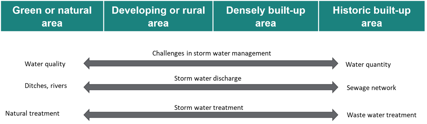
The RAINMAN project is based on an assumption that nature-based solutions can be easier to implement in developing areas but on densely built-up or historical areas novel solutions might not be possible to realise and traditional methods to handle stormwaters are more feasible. Therefore, a decision was made at the outset of the project to specify solutions for different land use types that have comparable characteristics in Finland and Russia. It was agreed to divide solutions in four different categories: green or natural areas, developing or rural areas, densely built-up areas, and historical built-up areas. Analysing similar land use types in the project case study areas enables sharing best practices and cross-border learning in common challenges.
The results of this work can benefit both the RAINMAN project partners as well as wider audience in other urban areas, especially professionals working on urban water management issues.
This report intends to respond to the following questions:
- How is a "green" or "nature-based" stormwater management solution defined?
- What are the good practices and solutions to stormwater management in the Helsinki Metropolitan Area’s cities?
- Are certain types of solutions favoured?
- Which kinds of solutions are planned at the moment?
- What are the co-benefits?
- How are these solutions monitored or maintained?
- What types of governance structures or strategies cities have have adopted or put in place?
- What factors have facilitated these solutions, and what obstacles still remain?
Chapter 3 provides a brief overview of concepts and definitions related to the stormwater management, and nature-based solutions especially in the stormwater management context. Chapter 4 introduces the Helsinki Metropolitan Area in the study context, while Chapter 5 presents the materials and methods used in this work. In Chapters 6-9, selected stormwater management solutions in the HMA are showcased. Chapter 10 discusses the findings, and Chapter 11 provides conclusions.
Stormwater management solutions - from grey to green
The term stormwater management implies different types of measures that impact the accumulation of stormwater, or are related to the conveying or treating of stormwater. There are various stormwater management methods that are essentially structural solutions. A distinction can be drawn between so called "grey" and "green" stormwater management solutions (EEA 2021, Kuntaliitto 2012, US EPA 2021):
- Grey solutions: conventional engineered infrastructure designed to move stormwater away from the built environment; collect and convey stormwater from impermeable surfaces (roads, parking lots, rooftops) into pipe system that ultimately discharges untreated stormwater into a local water body.
- Green solutions: designed to mimic natural processes and capture rainwater where it falls; reduce and treat stormwater at the source; vegetation plays an important role; provide multiple (co-) benefits.
This division of solutions can be considered as part of the stormwater management systems presented in the next section.
Stormwater management systems
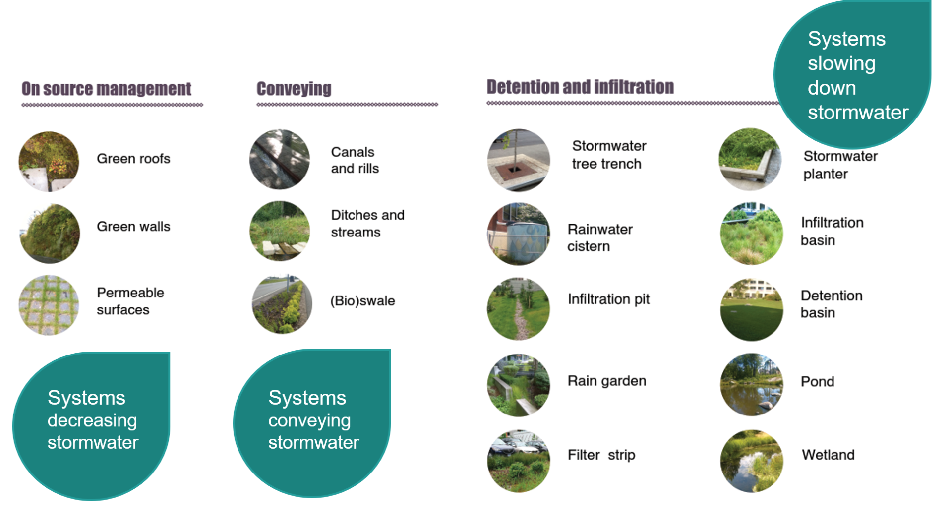
There are slightly varying ways to categorise stormwater management systems – and these are often combined in practice – but in general terms, they can be divided into three categories according to their operating principle (Fig. 3) (Kuntaliitto 2012, Lähde and Ariluoma n.d.):
- On source management, i.e. systems avoiding or decreasing stormwater;
- Conveying, i.e. systems conveying stormwater; and
- Detention and filtration systems, i.e. systems slowing down stormwater.
On source management systems concentrate on avoiding or decreasing stormwaters by limiting the amount of impermeable surfaces, filtrating stormwaters that have formed, and evaporating them with help of vegetation. These include permeable surfaces (like porous asphalt), green – or vegetated – walls and roofs, and maintaining the existing vegetation. On source management is the primary focus of stormwater management as only through these types of measures can the hydrological cycle be restored to the state before construction.
There are two types of conveying systems that convey stormwater, above- and underground systems. These include open ditches and streams as well as canals, channels and rills; also (bio)swales can be considered as conveying systems.
Systems slowing down stormwaters include various types of structures that detain, retain, filtrate and/or infiltrate stormwaters. These can be detention basins or ponds that have a permanent water surface area; or wetlands that have a lower water level but stay moist throughout the year and are typically covered by water and wetland vegetation. Vegetation covered basins, pits or depressions can be called for instance biofiltration or bioretention areas, or rain gardens. There are also depressions (aboveground) or pits (underground) that are not covered by vegetation, and therefore are not built with an infiltration or storage layers.
The scale of these solutions varies from local or small scale to regional or large scale solutions. The aim of the local (plot- or neighbourhood-scale) solutions is often to reduce the amount of stormwater, level off flow peaks and remove the impurities carried by the stormwater as near as possible to the source. Regional-scale solutions in turn aim to reduce and level off flood risk caused by stormwater. (Kuntaliitto 2012).
Chapters 6-9 present more in detail some of these systems through the selected green or nature-based stormwater management solutions in the Helsinki Metropolitan Area cities.
From quantity to quality management
With climate change advancing, it is anticipated that the amount of stormwater will increase and their purification need considerably grows (Kuoppala 2021). The quality of stormwaters is generally weakened as the cities grow denser (Valtanen 2015) and it can greatly vary in time and between locations in particular in urban areas (Eriksson et al. 2007 cited in Oral et al. 2020). The most common harmful substances in stormwater are solid matter, nutrients, heavy metals, chloride, oils and fats and other organic compounds such as polycyclic aromatic hydrocarbons (PAH compounds) and pesticides. They can also contain pathogens (such as E.coli) and bacteria. (Kuntaliitto 2012).
Land use has a great impact on the harmful substances in stormwater. In residential areas’ stormwater, there are usually high amounts of bacteria and nutrients whereas there are more metals in industrial and traffic areas’ stormwater. (Kuntaliitto 2012, Vahtera and Lahti 2016). Kuoppamäki et al. (2014) and Jokela (2008) have shown that the more heavily trafficked streets are, the more there are impurities in the stormwater.
The need to manage the quality of stormwater in Finnish city centre areas have been indicated at least in terms of solid matter, phosphorus, heavy metals like zinc and copper, and nitrogen (Helsingin kaupunki 2021a, Sillanpää 2020); in Helsinki also oil hydrocarbons and chloride have been considered to need more investigation (Airola et al. 2014).
Nature-based solutions for stormwater management
Urban sewage systems are designed for rains with certain intensity, and water from heavier rains, as a result of the impact of climate change, is directed to flood routes. In other words, the sewage system is not designed to handle all that water. Therefore, there is a need for decentralised and integrated water management.
Nature-based solutions (NBS) can act as an umbrella concept to various other concepts regarding sustainable urban water management (European Commission 2021a, see Fig.4). The concept of nature-based solutions was originally coined by the International Union for Conservation Nature (IUCN) (Cohen-Shacham et al. 2016; for the discussion on the evolution of the concepts, see for instance Ramírez-Agudelo et al. (2020) and Hanson et al. (2020)). However, the first use of the concept can be dated to the late 2000’s in the context of seeking solutions that connect climate change mitigation and adaptation, biodiversity protection and sustainable livelihoods (Eggermont et al. 2015).
The NBS are defined by the European Commission (2015, p. 4-5) as follows:
“Nature-based solutions aim to help societies address a variety of environmental, social and economic challenges in sustainable ways. They are actions which are inspired by, supported by or copied from nature….They have tremendous potential to be energy and resource-efficient and resilient to change, but to be successful they must be adapted to local conditions….Many nature-based solutions result in multiple co-benefits for health, the economy, society and the environment, and thus they can represent more efficient and cost-effective solutions than more traditional approaches.”
Alternative responses implementing nature-based solutions in the water management context are: “Low Impact Development” (LID) in North America, “Water Sensitive Urban Design” (WSUD) in Australia, “Sponge City” in China, “Sustainable Urban Drainage Systems” (SUDS), “Integrated Urban Water Management” (IUWM), and “Edible Cities” (Ramírez-Agudelo et al. 2020).
According to Ruangpan et al. (2019), the most common nature-based solutions applied in urban areas seem to be (intensive or extensive) green roofs, rain gardens, rainwater harvesting, dry detention ponds, permeable pavements, biofiltration (or retention), swales with vegetation as well as trees. Stormwater management systems mentioned in Section 3.1 can in many cases be considered nature-based systems as they take inspiration from or imitate nature and natural processes, offer benefits in terms of and beyond stormwater quantity and quality management, and can be cost-effective solutions especially in less extreme hazard scenarios and when co-benefits are considered in the long term (Seddon et al. 2020, see also Le Coent et al. 2021). Often these systems are in fact a combination of green and grey solutions, as the stormwater is directed to sewer systems after treatment with nature-based systems (EEA 2021, see also Wendling and Holt 2019). These can also be called “the most natural technological solutions” or eco-engineering (Oral et al. 2020). In fact, Seddon et al. (2020) argue that there is a need to focus on finding synergies among various solutions instead of framing NBS as an alternative approach to engineered solutions.
NBS have been addressed in the urban water management context recently e.g. by EEA (2021) and OECD (2020). In addition to introducing systems and structures mentioned in Section 3.1, removing excess asphalt and concrete in urban spaces can offer opportunities to implement NBS by reopening channelised watercourses and restoring riverbanks. Such solutions are more likely to be large-scale NBS, realised across landscapes, intersecting different ecosystems, and designed to reduce flood risk. Small-scale NBS in turn are typically implemented within a specific place, such as a single building or street (EEA 2021). These small-scale solutions have been found to reduce urban run-off by 30-65 % for porous pavements, up to 100 % for rain gardens, and up to 56 % for infiltration trenches (Ruangpan et al. 2020). Combination of NBS measures can lead to an improved performance in terms of runoff volume and peak flow reduction. For instance, combining detention ponds and rain garden, urban runoff volume reduction can be up to 71% (Goncalves et al. 2018 cited in Ruangpan et al. 2020). One of the most known – and successful – international examples of combining a number of NBS measures at the city scale is the Sponge City Programme in China (Ruangpan et al. 2020).
A nature-based solution aimed at a specific societal challenge is likely to produce co-benefits in other challenges (Raymond et al. 2017). In the urban water management context, this can mean benefits either beyond stormwater quantity management, or both quantity and quality management. When latter co-benefits of nature-based solutions for water management are considered especially in small-scale, urban context, they include supporting biodiversity, improving aesthetic and recreational value, or promoting social cohesion and inclusion as well as strengthening a sense of place within urban areas (Song et al. 2019 cited in EEA 2021). They can, for instance, help reduce noise pollution and the urban heat island effect, and hence contribute to enhancing quality of life. Solutions like vegetated roofs or facades can promote food production and provide insulation and therefore reduce the need for cooling or heating, and thus energy consumption. (Frantzeskaki, 2019, UNaLab, 2019 cited in EEA 2021, Oral et al. 2020). NBS can also contribute to carbon sequestration, and enhancing mental and physical health (Jessup et al. 2021). NBS can act as a “no-regrets” measure to adapt to the effects of climate change because they can provide benefits even without climate change (Hallegatte 2009 cited in OECD 2020, p.9). Furthermore, Hankonen et al. (2018) point out that by applying nature-based solutions, cities can find new ways to use city spaces and raise the appreciation of residential areas as well as respond simultaneously to several obligations, such as the development of water protection, leisure services, green infrastructure and biodiversity.
OECD (2020) provides international examples of the realised potential of the NBS to manage urban flooding. For example, investing EUR 22 million to retrofitting of drainage systems to include nature-based systems in Augustenborg in Malmö, Sweden resulted in a reduction of urban runoff by 50 % and a substantial increase in biodiversity (European Commission 2015). In Portland, Oregon, USD 250 million were estimated to have been saved in stormwater infrastructure costs when green alleys and tree planting were implemented with an USD 8 million investment (Foster et al. 2011 cited in OECD 2020).
For these benefits to be realised, nature-based solutions need to be carefully planned and designed. The effectiveness of NBS depends on the type and design of the solution, scale and purpose of implementation as well the local conditions and cultural setting (EEA 2021, Ruangpan et al. 2020). Participatory approaches and the inclusion of stakeholders’ perspectives from early stages of the design are said to be essential to ensure the effectiveness in realising multiple benefits and public acceptance as well as justifying investments in such options (EEA 2021, see also Le Coent et al. 2021). Moreover, siting of NBS can be vital: Jessup et al. (2021) found that the largest social and public health benefits may be delivered when NBS are implemented in and around heavily developed areas; whereas greatest water quality benefits can be accrued when NBS are sited in areas with a high density of commercial and industrial land uses. In addition, the implementation of NBS is argued to demand continuous monitoring (Gałecka-Drozda et al. 2021).
Orta-Ortiz and Geneletti (2021) investigated the performance of various NBS types to manage stormwater in urban areas, reviewing research from the last 10 years in the field. They found that effectiveness to meet stormwater management objectives highly varies – even when considering the same type of solution – due to the characteristics and dimensions of NBS (e.g. soil porosity, plant species and substrate depth) and the local conditions (e.g. rainfall patterns, temperature and maintenance practices). They conclude that there remains a knowledge gap with regard to the relationship between these factors and the performance of nature-based solutions (Orta-Ortiz & Geneletti 2021). The vital role of local context in NBS application is emphasised also by Rehunen et al. (2021).
However, NBS can also have trade-offs, and face various barriers or limitations. For instance, the construction work related to their implementation may negatively impact the water quality downstream, or they can create conditions for unwanted organisms to thrive (e.g. mosquitoes) (EEA 2021). Limitations stem largely from the lack of knowledge with regard to the effectiveness of NBS and insufficient planning or design of the solutions. Nature-based solutions often require more space than traditional grey structures, which can lead to high opportunity costs due to land values being high (EEA 2021); limited space available is a major shortcoming especially in densely built urban areas and protected historical city centres (Oral et al. 2020). Therefore, including the economic and social values of various benefits in cost assessment of NBS is central (EEA 2021, Le Coent et al. 2021).
It is evident that nature-based solutions are complex and require the consideration of multiple benefits and limitations (Luxton 2021). Adding to the complexity, stormwater management is increasingly regarded a multidimensional and multidisciplinary issue (Oral et al. 2020). A lack of tools to assist identifying the impacts of NBS in a holistic manner to support decision-making has been brought forward e.g. by Luxton (2021) and Paloniemi (2019). However, guidance is increasingly available: for instance, European Commission (2021a) has recently published a handbook for practitioners on evaluating the impact of NBS. It offers an overall evaluation framework for NBS with a protocol for selection of key indicators of NBS impact and methods for their assessment. Furthermore, Raymond et al. (2017) introduce a framework for assessing and implementing the con-benefits of nature-based solutions in cities. Le Coent et al. (2021) present a methodological framework for the economic assessment of NBS for water related risks. In addition, the interactive mapping tool of the University of Oxford (n.d.) helps to link nature-based solutions to climate change adaptation outcomes.
In the Finnish context, a project called TASAPELI (“Efficient and effective nature-based solutions as tools for climate change adaptation”, 2018-2019) developed an approach that aims to advance comprehensive recognition, evaluation and consideration of the NBS’ benefits in stormwater management related planning. Paloniemi (2019) called for comprehensive planning and wide-ranging cooperation between different actors, and suggested that researched knowledge, good practices and past experiences will help implement nature-based solutions. In addition, Luxton (2021) proposed a methodology to prioritise large-scale nature-based solutions in the City of Helsinki to assist municipal decision-makers with strategic implementation of NBS for stormwater management.
Due to the NBS being characterised by multiple benefits, they essentially require seamless and sustained cooperation of actors not only in planning and implementation but also in terms of funding of such solutions (Vikström et al. 2019). Rehunen et al. (2021) argue that main barriers to NBS applications in the urban water management context are often found in governance, regulation, organisational interaction, and planning practices. In addition, they consider the biggest opportunities for development to be found in the political arena, institutional collaboration and knowledge production (Rehunen et al. 2021). Bohman et al. (2020, p. 2) presents that the biggest challenge in transforming the stormwater management sector to become more sustainable is about “developing new working procedures and planning routines that involve wider actor collaborations” rather than advancing technology. In their study on Swedish municipalities, Bohman et al. (2020) recommend networks on vertical collaboration to ensure stormwater related planning ambitions are maintained from the planning to the implementation stage, and further, to facilitate mutual learning and dialogue.
Nature-based solutions in stormwater management were found to be driven in Malmö and/or Copenhagen by a collaborative culture, establishment of official steering groups in addition to existing climate change adaptation plans and previous experience in implementing NBS (Udomcharoenchaikit 2016). Good examples and best practices on nature-based solutions, also in the urban water management context, are provided, for instance, by the Urban Nature Atlas (2021) database and Oppla (2021) platform. Furthermore, various ongoing EU-funded Horizon 2020 projects are shedding light on the barriers and success factors of nature-based solutions. In the urban water management context, the projects include UNaLab, Grow Green, Urban GreenUP and Connecting Nature (European Commission 2021b). Atenas is one of the ongoing projects (funded within the EU Water JPI) that has studied critical factors for replication and upscaling of NBS in urban water management context (Rehunen et al. 2021). In addition, a Finnish project titled Baltic Sea Cooperation for Climate Resilience – Flood and Drought Risk Management has provided insights into nature-based and natural flood risk management solutions also in the stormwater management context (Parjanne and Marttunen 2021).
It is noteworthy that the idea of taking inspiration from nature or replicating natural processes is older than the concept of nature-based solutions that became more common in the late 2010’s. Identification and utilisation of nature-based solutions in urban stormwater management has become established worldwide. However, in urban planning NBS are stated to be still in the experimentation phase due to the challenges in connecting their benefits to urban planning. (Hankonen et al. 2018 cited in Vikström et al. 2019). In the Finnish water management context, it was reported that "natural" stormwater management was arriving to Finland and tested in projects in the late 2000’s; and that there was only a little experience at the time on such "ecological" management methods compared to the other Nordic countries (Pihlajamaa 2010). Fast forward 10 years, nature-based solutions are swiftly becoming more common (Valtanen 2021).
Currently, Finnish municipalities appear to be well aware of the stormwater related challenges and many of them have developed a stormwater management plan or a program. While stormwater has earlier been connected to draining and underground structures, it is nowadays increasingly seen as a resource and an opportunity to create attractive and interesting living spaces for city dwellers. Also, natural or nature-based management solutions are emphasised, and stormwater directed as part of the natural water cycle in stormwater management planning. The quality treatment is becoming more and more important in the future. (Ala-Prinkkilä 2019).
Characterising the Helsinki Metropolitan Area
Helsinki Metropolitan Area and stormwater related challenges
The Helsinki Metropolitan Area comprises of four cities: Helsinki, Espoo, Vantaa and Kauniainen. It is an important growth centre with a population of 1.2 million in the autumn 2021 (Statistics Finland 2021), i.e. roughly one-fifth of the Finnish population. The HMA is one of the country’s most significant foci in new construction. The Helsinki Metropolitan Area belongs to the Helsinki-Uusimaa Region. Main stormwater management challenges defined in the RAINMAN project include increasing impermeable surfaces, capacity of the stormwater sewer network, combined sewerage in the centre of Helsinki, varying quality of stormwater as well as storing of stormwater data in many different places (Jarva et al., forthcoming).
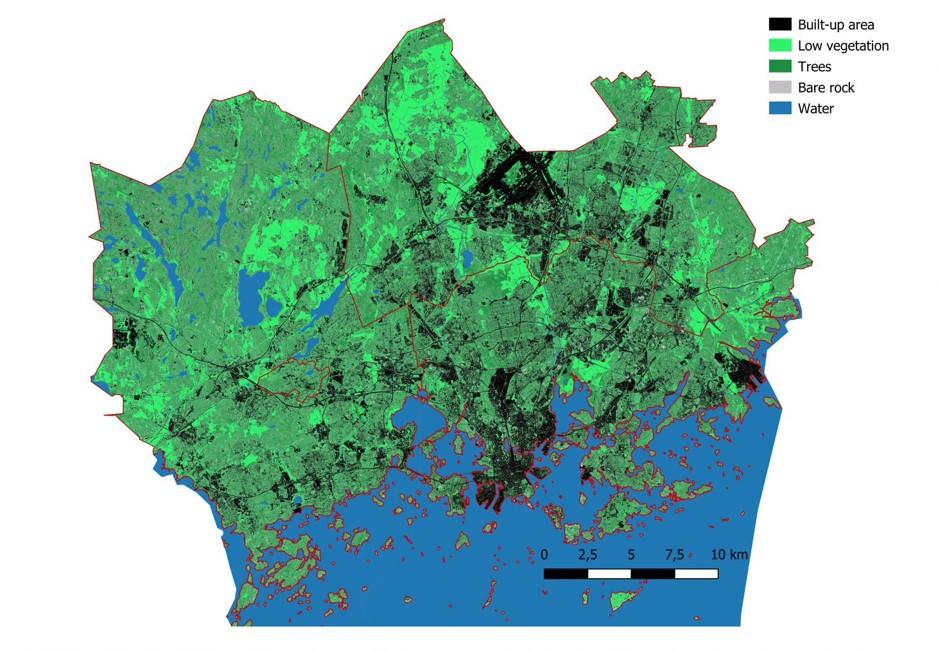
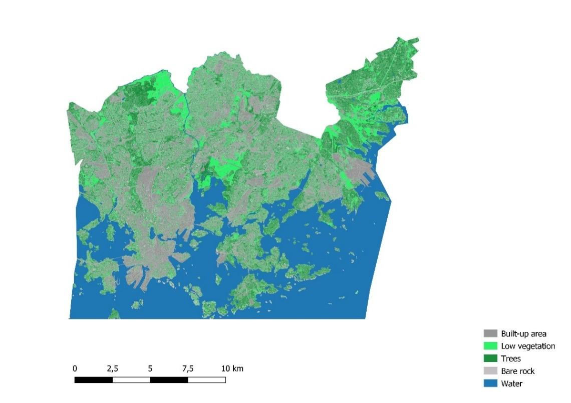
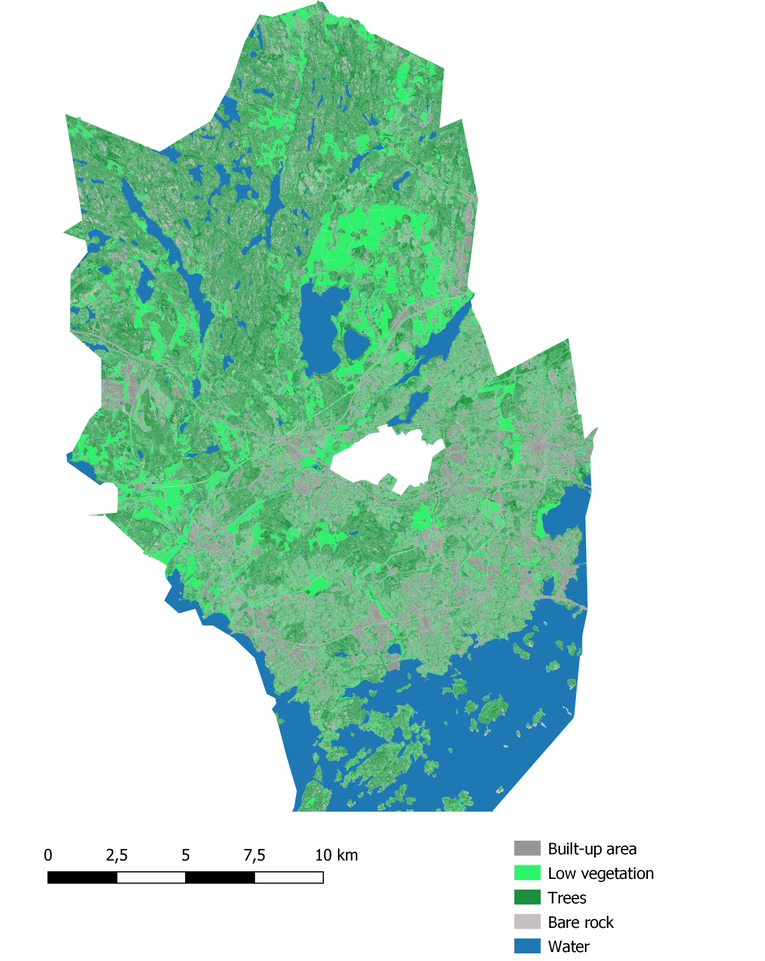
Even though Finland is generally speaking a sparsely populated compared to many other countries, even here cities face the pressures of densification. Figure 5 shows the impermeable surface area in the HMA: 28% of the surface area is built-up (including roads, buildings, other impermeable surface as well as bare rock), 69% is vegetation (low vegetation and trees) and 3% inland water.
With regard to the land use types defined at the outset of the project, only Helsinki has historic built-up areas; the rest of the HMA cities include the other three land use types (green or natural areas, developing or rural areas, densely built-up areas).
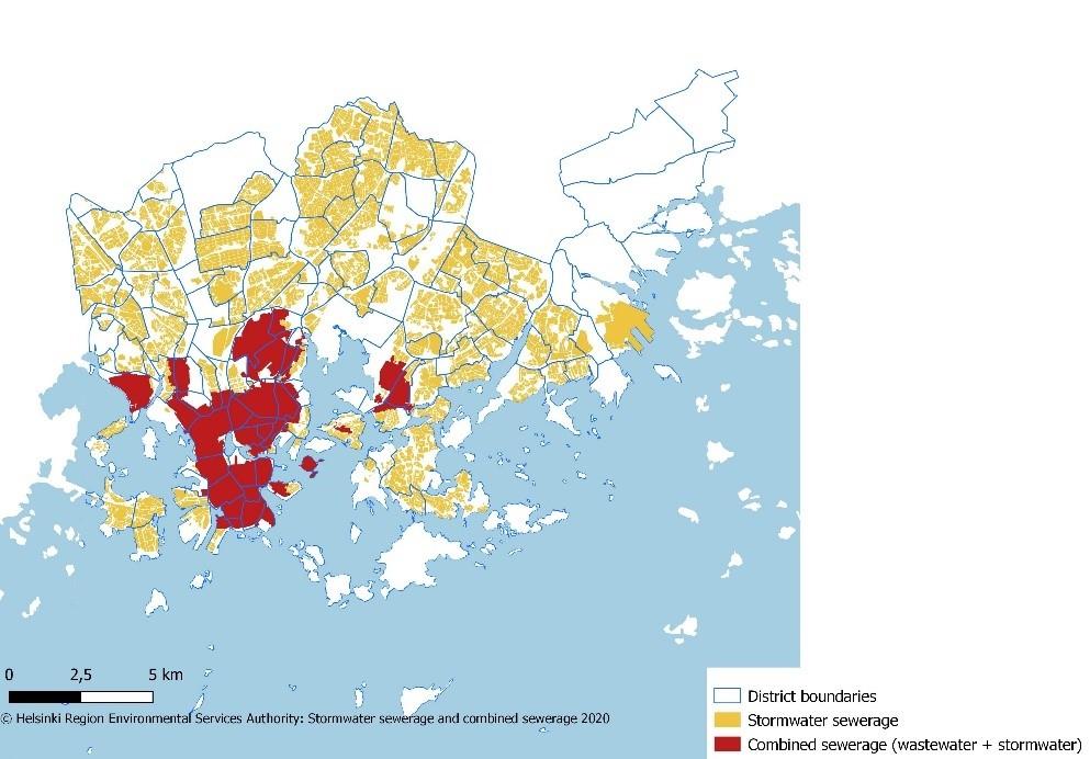
Central Helsinki includes the historic and densely built-up areas and has a combined sewer system: the wastewater and stormwater are conveyed to the same sewer and onto the Viikinmäki wastewater treatment plant (Fig. 6). In the event of heavy rains, a quick peak of stormwater can form. This increases the risk of overflow of the combined sewage system, which in turn means that impurified water can eventually end up in the Baltic Sea. Moreover, stormwater cools down the wastewater and hence reduces the treatment efficiency at the wastewater treatment plant (HSY n.d.b). There are plans to separate stormwater from the combined sewer in a few parts of central Helsinki, but this is expected to happen slowly (Ala-Prinkkilä 2019).
With regard to the challenge related to managing stormwater data, it has been recognised that these data concerning stormwater, e.g. data on sewers, retention structures, ditches and streams are scattered and have been stored under different organisations. HSY identified the need to develop the management of stormwater data and started a project on a shared stormwater database (HUTI – Hulevesitiedonhallinta, i.e., stormwater data management) in 2019. Such a shared database allows for a more effective city planning, street design and maintenance of the abovementioned structures. After the formulation of a suitable content structure for the database, the project work includes standardising all data to the HUTI format and building a GIS-based application for the users of the stormwater data. The HUTI database is intended for professional use and requires a personal licence.
Stormwater management duties and responsibilities
Stormwater management duties and responsibilities are divided between the metropolitan cities, owners or occupiers of properties, and the joint municipal authority Helsinki Region Environmental Services, HSY. The following points are based on the legislation and the stormwater management agreements between the HSY and the HMA cities (HSY, n.d.c):
- Cities are responsible for planning of the stormwater management as a whole within their territory. This includes preparing a stormwater management plan, assessing stormwater flood risks, and taking care of stormwater management in public areas, such as water removal from streets and flood routes. In addition, cities are responsible for the construction and maintenance of the municipality’s stormwater systems, such as open ditches as well as detention and retention structures.
- HSY is responsible for the construction and maintenance of the main stormwater sewer network in a separately defined stormwater sewerage area and owns the stormwater pipe network. HSY provides stormwater sewerage services in this stormwater sewerage area approved by its member municipalities. HSY charges connection fees and basic rates for stormwater sewerage.
- The owner or occupier of the property is responsible for the drainage of the building and the management of stormwater formed on the property. They should have a plan for conveying and treating stormwater. Stormwater can be infiltrated and detained as well as conveyed into HSY’s stormwater sewer or the municipality’s stormwater system in a controlled manner. The property must be connected to HSY’s stormwater sewer if it is located in the stormwater sewerage area. Even if the property owner infiltrates stormwaters in their property, that does not remove the obligation to join the HSY’s stormwater sewer system.
As a rule, stormwater conducted into the stormwater sewer network is not treated, but rather discharged into water bodies as such. Stormwaters must not be conducted into the wastewater sewer network except in the combined sewerage area.
Steering mechanisms related to stormwater management
Essential steering measures and legislation on stormwater management are (the most important ones are bolded) (Airamo 2018):
- Land Use and Building Act and its amendment (Maankäyttö- ja rakennuslaki 132/1999, Laki maankäyttö- ja rakennuslain muuttamisesta 682/2014)
- Water Services Act (Vesihuoltolaki 119/2001)
- Water Act (Vesilaki 587/2011)
- Flood Risk Management Act (Laki tulvariskien hallinnasta 620/2010)
- Act on the Organisation of River Basin Management and the Marine Strategy (Laki vesienhoidon ja merenhoidon järjestämisestä 1299/2004)
- Environmental Protection Act (Ympäristönsuojelulaki 527/2014)
- Street and specific public areas’ maintenance act (Laki kadun ja eräiden yleisten alueiden kunnossa- ja puhtaanapidosta 699/1978; no English translation)
- Decree of the Ministry of Environment on water and sewer equipment of buildings (Ympäristöministeriön asetus rakennusten vesi- ja viemärilaitteistoista 1047/2017; no English translation).
Importantly, the Land Use and Building Act was amended in 2014 (with a new chapter 13a) to reduce stormwater damages and to require municipalities to organise stormwater management in their local detailed plan areas. Essentially, the general objectives of storm water management specified in the law are as follows (City of Helsinki 2018; Ympäristöministeriö 2014):
- developing systematic stormwater management especially in areas where a local detailed plan is in force;
- infiltrating and detaining stormwater at the source;
- preventing the impacts and damages to the environment and property caused by stormwater, while taking account of climate change;
- promote giving up the practice to convey storm water into wastewater sewers.
Regulation of stormwater management was considered appropriate to include in the Land Use and Building Act because stormwaters need to be taken into account both in land use planning and building. Good stormwater management is part of a healthy and safe living environment, which is also the objective of town planning. (Ulvi 2016).
In addition, a comprehensive guide of the Association of Finnish Local and Regional Authorities (Kuntaliitto, 2012) on stormwater management emphasises integrated stormwater management and source control. The Finnish Association of Landscape Industries (Weckman 2018) has also published a guiding document on an operational model for sustainable environmental building that includes stormwater management. This organisation is also currently preparing a maintenance classification as well as quality criteria of natural stormwater structures (VYL 2021).
Furthermore, municipalities have to assess stormwater flood risks according to the law (Act 620/2010). This means carrying out an initial assessment of stormwater flood risks and naming of possible significant stormwater flood risk areas. If this assessment shows such significant stormwater flood risk areas, then the municipality needs to develop more detailed assessments, flood risk maps and stormwater management plans. The nation-wide stormwater flood risk assessment round ended in 2018, the next will take place in 6 years. This is because land use is continuously changing, and heavy rains are increasing. (Ala-Prinkkilä 2019). In the 2018 assessment, no significant stormwater flood risk areas were found in the HMA cities.
In the Helsinki Metropolitan Area, three out of four cities have a stormwater management program (Helsinki, Espoo and Vantaa). Stormwater management issues are also recognised in the cities’ climate change adaptation plans. In addition, they have been included in the HMA wide climate change adaptation strategy for the years 2012-2020 (HSY 2012), and reported in the strategy’s monitoring reports. Sections 6-9 present the cities’ stormwater management documents more in detail.
Climate change impacts
Currently, summer is the rainiest season, and cloudbursts take place in the warmest time of the year in Finland. Valtanen et al. (2014, cited in Kuoppamäki 2021) has estimated that 65-69% of stormwater is formed in the summer. Thus far, smaller rain events have been most common in the country. (Kuoppamäki 2021).
The Finnish Climate Change Panel published a report on changes in weather and climate factors in each Finnish region in September 2021 (Gregow et al. 2021). According to the report, depending on how global greenhouse gas emissions will evolve in the coming decades, the mean temperature is expected to be 1,7 to 2,8 °C warmer than today in the Helsinki-Uusimaa Region by the end of the century. This is anticipated to lead to an increase in precipitation as shown in Figure 7. Figure 7 shows that even with strong emission reductions (in line with the IPCC RCP2.6 scenario), precipitation is anticipated to increase in winter, spring and autumn. The intensity of cloudbursts is on the rise in all seasons. (Gregow et al. 2021).
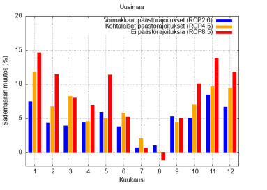
According to a report investigating climate change impacts in the Helsinki Metropolitan Area, both the mean and maximum precipitation will increase, especially in winter months, and heavy rainfall events in the summer will intensify by 10% during this century (Mäkelä et al. 2016).
Climate change is also expected to increase the volume of cloudbursts. Cloudbursts are usually a local phenomenon and the probability of heavy rainfall to land in densely built urban areas is relatively low (Mäkelä et al. 2016). However, cloudburst events like the ones in Pori (August 2007), and Helsinki (August 2019) indicate that heavy rains can cause considerable damage (Hevonoja et al. 2019, SYKE 2021).
The risk of stormwater floods will increase in the future along with increased cloudburst events, and this risk is recommended to be prepared for. Estimated climate change impacts also include sea level rise and increased risk of sea floods. (Gregow et al. 2021). This is expected to affect stormwater management systems especially if cloudburst events and elevated sea levels happen simultaneously.
Methodology
Scope
This research was guided by the RAINMAN project Task 5.4. description: “In this task the role of green infrastructure and vegetation will be studied as part of sustainable stormwater management. The aim is to identify good practices and solutions to stormwater management in urban areas and also as protection of freshwater resources especially from increasing stormwater amounts.”
This was translated into a report introducing “alternative green solutions” to reduce negative impacts of stormwater targeted at the four land use types defined in the project. Such solutions were considered to include various types of “green”, “natural” or “nature-based” stormwater management structures. A common term “nature-based solutions” was adopted in the report as an umbrella term to refer to more sustainable approaches to stormwater management (see Section 3.3.).
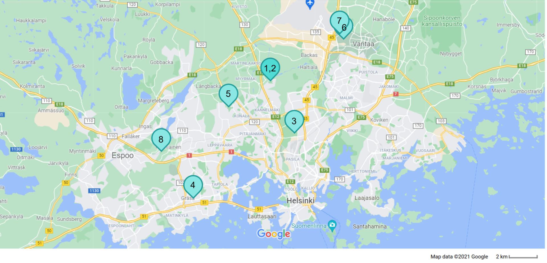
As this task was assigned in the project to the Helsinki Region Environmental Services Authority HSY, the Helsinki Metropolitan Area was selected as the area under investigation. Eight stormwater management solution sites were selected from the initial larger set of sites in the HMA based on the discussions and interviews with the cities' staff as well as findings in the literature (see Table 1 and Fig. 8). The selection founded upon the following criteria:
- Local scale, aboveground, ground level solutions (e.g. mainly excluding green roofs);
- Different types of solutions in terms of systems, time built, location (residential areas vs. industrial areas), land use types, size, innovation, visibility;
- Structures in public areas;
- Research or monitoring data available to determine the performance of these solutions;
- Recommended by the cities' staff members; and
- Not/ less photographed earlier.
With regard to the land use types, they were not defined in detail at the outset of the project. Hence, the selected sites could be categorised to exhibit more than one land use type depending on their location. Land use types were discussed in the RAINMAN project meeting in March 2021. Challenges and solutions to stormwater management in different land use types were also workshopped with the project members in the meeting in November 2020 (Table 2, Appendix). These discussions helped refine the research scope.
Number | Name | City | Land use type | Building year | Management type | Solution |
|---|---|---|---|---|---|---|
1 | Fannynkallio residential area, Kuninkaantammi ecological district | Helsinki | Developing/ densely built-up area | 2019 | On source management, conveying, detention & infiltration | Permeable surfaces, green roofs, rain gardens |
2 | Helene Schjerfbeck’s park, Kuninkaantammi ecological district | Helsinki | Green or natural/ developing area | 2018 | On source management, conveying, detention & infiltration | Streams, channels, swales, detention basins and wetlands |
3 | Maunulanpuisto park | Helsinki | Green or natural area | 2015 | Detention & infiltration | Detention basins, biofiltration area, ditch |
4 | Merituulentie road | Espoo | Developing/ densely built-up area | 2018 | Detention & infiltration | Biofiltration swales |
5 | Huhuilijanpuisto park | Espoo | Green or natural area | 2013 | Detention & infiltration, conveying | Wetland, ditch |
6 | Koisotie road snow reception area | Vantaa | Green or natural area | 2013 | Conveying, detention & infiltration | Biofiltration area, wetland |
7 | Meiramitie road | Vantaa | Densely built-up area | 2014 | Detention & infiltration | Biofiltration swales |
8 | Skvatterbäck creek | Kauniainen | Green or natural area | 2009 | Conveying, detention | Creek |
Materials and methods
The research underpinning this report is based on a literature review, interviews and photography of selected sites. The research was carried out mainly in February – November 2021. The review of literature included various types of peer-reviewed and ‘grey’ literature, such as cities’ stormwater management programs and other relevant publications (e.g. maps), publications related to nature-based solutions, relevant project reports, journal articles, theses as well as the RAINMAN project material. Given the increasing amount of literature published on the topic of nature-based solutions and urban water management, this review is not intended to be exhaustive but provides a snapshot of current research, practices and lessons learnt in the field.
The literature review was complemented by semi-structured interviews with staff members of all four HMA cities. These four interviews were carried out online in June – July 2021; one of them was a group interview. Altogether seven persons were interviewed. In addition to the interviewees, six other persons were more informally discussed with on the phone, and/or consulted by email to ask for more clarifications in the latter half of 2021. These all are called informants, and they were deemed key persons dealing with stormwater management and/or climate change adaptation related issues in their cities. Therefore altogether 13 people acted as informants:
- City of Helsinki: one interviewed; two consulted by email and/or phone;
- City of Espoo: one interviewed; one consulted by email and/or phone;
- City of Vantaa: one interviewed; three consulted by email and/or phone;
- City of Kauniainen: four interviewed.
The interview questions were structured around the initial research questions presented in Section 2.1. The interview recordings were transcribed and translated from Finnish to English, and then categorised and analysed according to the initial research questions. Due to the rich interview data, most of it was included in the report.
In addition, a photographing plan was developed to depict the selected solutions. The sites were visited by the photographer mainly in August – September 2021. The author visited the Helsinki sites with the photographer to guide the photographing process. Aerial photos were taken from all except the Vantaa sites as the proximity of the airport prevented the drone to be used.
Selected stormwater management solutions in Helsinki
City of Helsinki is growing fast. The population is currently circa 657 000 inhabitants, and it is estimated to go beyond 700 000 in 2028 and reach 824 500 inhabitants by 2050. That means that the population is expected to increase by 200 000 inhabitants by 2057. (Helsingin kaupunki 2021b).
City of Helsinki has the highest built-up area among the metropolitan cities, 39% (Figure
To accommodate the growing population, the city needs to build new areas and make the city structure denser. Managing stormwater in a sustainable way has been recognised in the Helsinki City Strategy 2017-2021, “The Most Functional City in the World”, that calls for an increase in the amount of green areas in the city structure so as to promote cost-efficient stormwater management. Also, the new city strategy for 2021-2025 mentions the intention to increase green infrastructure to manage stormwaters and support climate adaptation. Utilisation of stormwater along with proper management advance also other city strategy objectives such as attractiveness of the environment, biodiversity, good state of small watercourses and adaptation to climate change. (City of Helsinki 2018, Helsingin kaupunki 2021c, Peltosaari et al. 2020).
The city developed its Storm Water Management Program in 2018 as part of the climate change adaptation strategy work. In addition to this strategic work, an update to the 2008 stormwater strategy was driven by changes in stormwater legislation as well as city management systems and organisational structures. The current Storm Water Management Program is integrated in its nature, which means that the program’s measures are implemented and developed as an integral part of city planning, construction, and other related processes, mainly within the existing operational budgets. The Storm Water Management Program was carried out within the iWater project (European Regional Development Fund, Interreg Central Baltic). (City of Helsinki 2018, Peltosaari et al. 2020).
The Storm Water Management Program includes six objectives and 38 measures. These objectives are (City of Helsinki 2018):
- Stormwater has been utilised for increasing the attractiveness of the environment, maintaining biodiversity and promoting a good condition of surface and groundwater.
- Regional and local drainage has been ensured while taking the impacts of climate change into account.
- The disadvantages caused by storm water have been prevented and eliminated in changing conditions and densifying city structure.
- Stormwater flow rates are under control and stormwater quality is improved.
- Conveying stormwater into wastewater sewer has been reduced.
- Cooperation and procedure models supporting systematic overall management of stormwater are in use, and sufficient competence and resources have been secured.
The management, treatment and conveying of stormwater follows the priority order set by the national level stormwater legislation. Various services of the city’s Urban Environment Division and so-called stormwater group are responsible for the implementation of the program measures. The measures are implemented in cooperation with other city services and divisions, HSY as well as different stakeholders and residents. (City of Helsinki 2018, Peltosaari et al. 2020).
The stormwater group consists of representatives of different services of the Urban Environment Division. It is primarily responsible for the last objective, including measures that concern the development of a cooperation and operations model, training of stormwater issues within the city organization, as well as monitoring and reporting of the implementation of the program. (City of Helsinki 2018, Peltosaari et al. 2020).
To assist with the implementation of the stormwater program and aim to increase green areas in the city, City of Helsinki uses a planning tool called the Green Factor. This tool provides means to account for the quantity and quality of green space. The tool has been developed to support land use planning processes, and is intended to be used by city planners, landscape architects and garden designers. Using the Green Factor tool is required in the zoning regulations and following building permits. (City of Helsinki 2018, City of Helsinki Environment Centre 2016, Juhola 2018, informant).
City of Helsinki is in the process of investigating nature-based stormwater management sites. Thus far there has not been a systematic mapping of such sites, and the knowledge has mostly been held by city staff dealing with city planning. Now the idea is to digitalise the data on the sites and transfer that onto a map. Therefore, there is not yet a maintenance card file of stormwater management sites but this process can found a basis for such a card file. (informant).
The selected sites in Helsinki consider the Kuninkaantammi ecological district (Fannynkallio residential area, Helene Schjerfbeck’s park) and the biofiltration area in the Maunulanpuisto park. Other sites worth mentioning in the city are for instance the Vauhtitie wetland in Töölönlahti bay (Tengbom, n.d.), and the Maunulanpuro brook biochar-based filtration area next to the Maunulanpuisto park biofiltration area (Helsingin kaupunki and Espoon kaupunki 2020). Recent studies that have looked into nature-based solutions in Helsinki include Kyyhkynen (2021) and Suni (2021).
Kuninkaantammi ecological district
Location: Kaarela neighbourhood, Hakuninmaa
Management / system type: on source management, conveying, detention & infiltration
Land use types: Developing (or rural) area / densely built-up area / green or natural area
Built: 2013/2015-2027 (pre-building started in 2013, building of houses in 2015; Helene Schjerfbeck’s park 2015-2018; Fannynkallio finished 2019) (Helsingin kaupunki 2015, 2021d; Laitinen 2021)
Size: Whole district 120 ha, Helene Schjerfbeck’s park ~10 ha (Helsingin kaupunki 2021d)
Catchment basin: Mätäjoki river, Vantaanjoki river (Sanaslahti 2019)
Description:
Kuninkaantammi is a developing district in the City of Helsinki, and it is halfway being built. It has formerly been mainly an industrial area that is being transformed into a climate friendly neighbourhood for 5,500 inhabitants. The district has taken as its starting point both climate change mitigation and adaptation. Buildings are energy efficient and use renewable energy. The district acts as a pilot area for stormwater management, in which new design solutions will be seen in parks and residential areas. The intention of this project is also to increase the cooperation of different city departments on the implementation of the city’s stormwater program and to clarify the responsibilities of various actors. (Helsingin kaupunki 2015, 2016, 2020; Ilmasto-opas.fi 2014).
The town plan of Kuninkaantammi requires that the stormwaters from the impermeable surfaces need to be detained in the area so that the detention depressions, basins and containers need to be 0,5 m3/ 100 m2 of impermeable surface area. The town plan also necessitates rain gardens in the residential areas as the primary means to detain stormwater. In addition, green (or vegetated) roofs are required to be built on all single-level buildings namely for the purposes of detaining stormwater. (Ilmasto-opas.fi 2014).
Infiltration of stormwater on site is possible only to a certain extent in Kuninkaantammi due to the ground being rocky and frictional soil; hence the stormwaters are infiltrated and detained partly via nature-based solutions on yards and streets until the stormwater is conveyed to Helene Schjerfbeck’s park and into Mätäjoki and Vantaanjoki rivers (Helsingin kaupunki 2020, Sanaslahti 2019). Treating and detaining stormwater in Kuninkaantammi is vital as conveying stormwater directly through the piping structure would lead to the flooding of streams in the residential area of Hakuninmaa (Helsingin kaupunki 2020).
While the capital investment cost of constructing the Kuninkaantammi stormwater management system is relatively high (e.g. Helene Schjerfbeck’s park’s stormwater structure costs were estimated in 2008 as 2,3 M€ (Helsingin kaupunginhallitus 2014)), nature-based (or natural as discussed in secti
Kuninkaantammi’s stormwater structures are reported to be monitored on how they function and how they are maintained (informant). While it is still rather early to determine how well the stormwater pilot area is functioning especially from the stormwater quality point of view (Kyyhkynen 2021), one study has investigated whether the stormwater management solutions of Kuninkaantammi have affected the water quality in Hakuninmaanoja stream when comparing the period before construction to after the construction of Kuninkaantammi district (2011-2018)(Sanaslahti 2019). Helene Schjerfbeck’s park was built before the construction of the housing areas in order to treat the stormwaters during construction before they were lead to Mätäjoki river (Helsingin kaupunginhallitus 2014). The study concludes that the water quality of Hakuninmaanoja stream seems satisfactory or good regarding most variables studied regardless of the construction activities. The stormwater solutions in the area during construction (rain gardens in the yards as well as the detention and retention pools of the Helene Schjerfbeck’s park) have resulted in low peak concentrations of suspended solids and total phosphorus when compared to prior studies on water quality changes due to construction. The study suggests that the stormwater pilot area is functioning successfully. (Sanaslahti 2019).
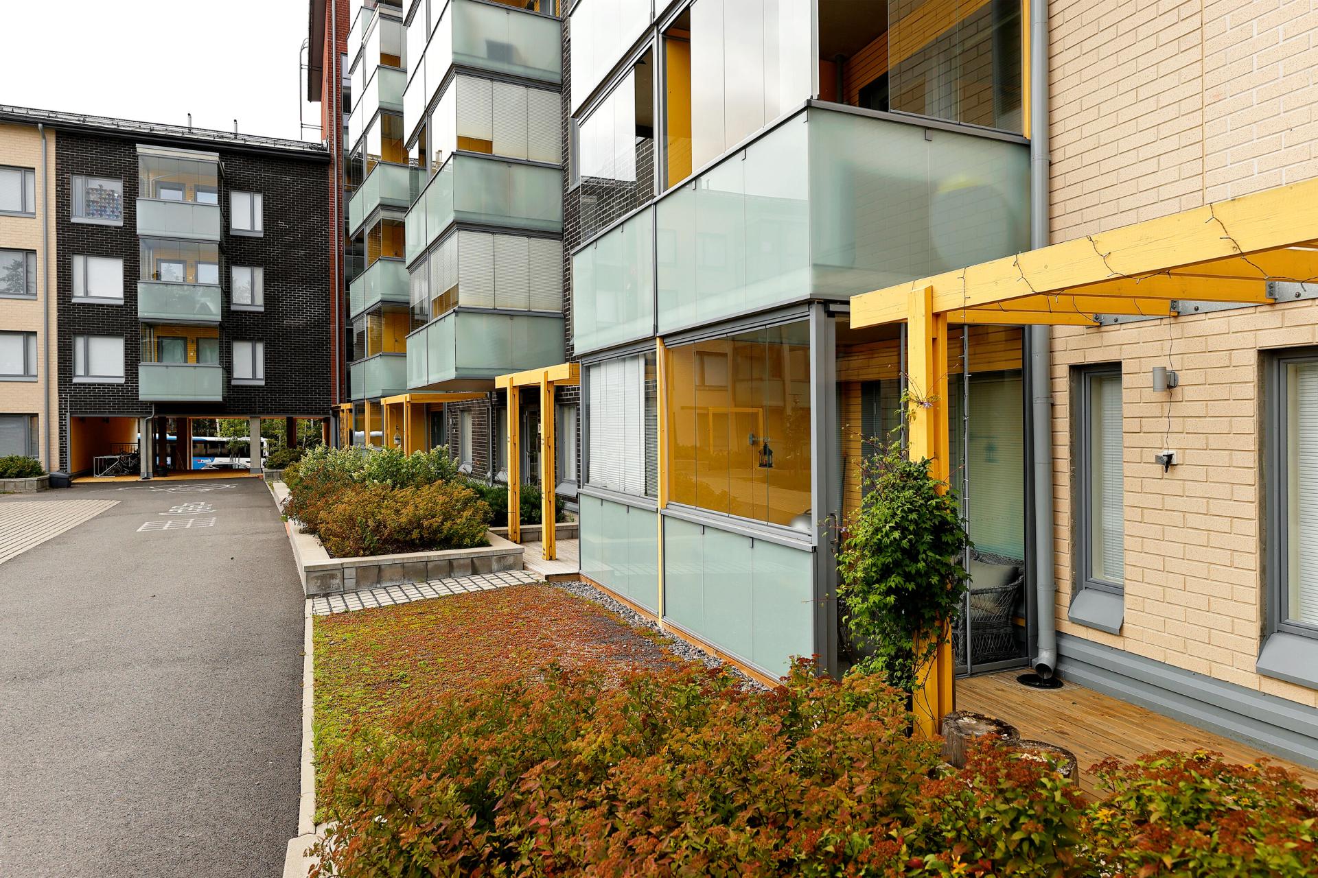
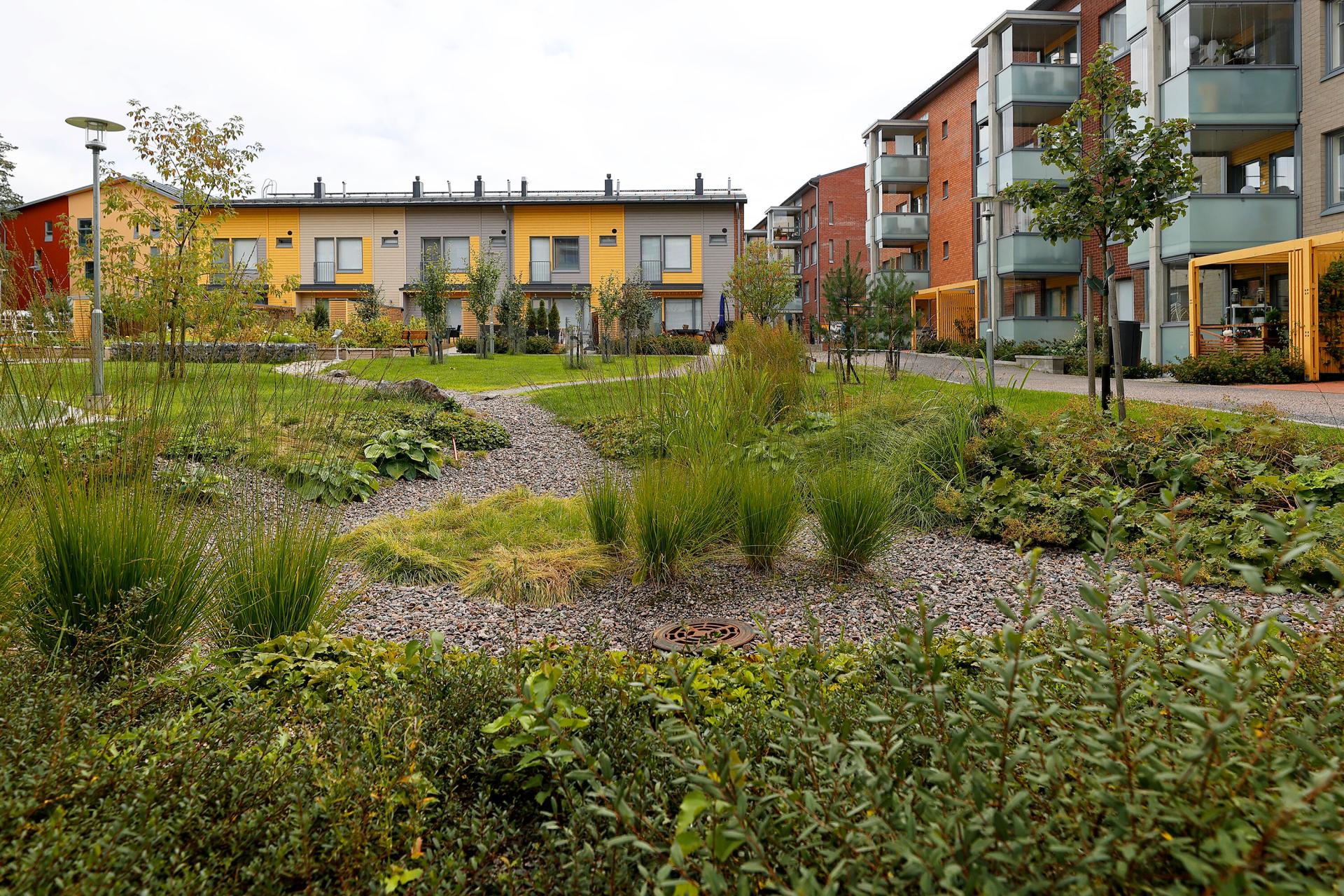
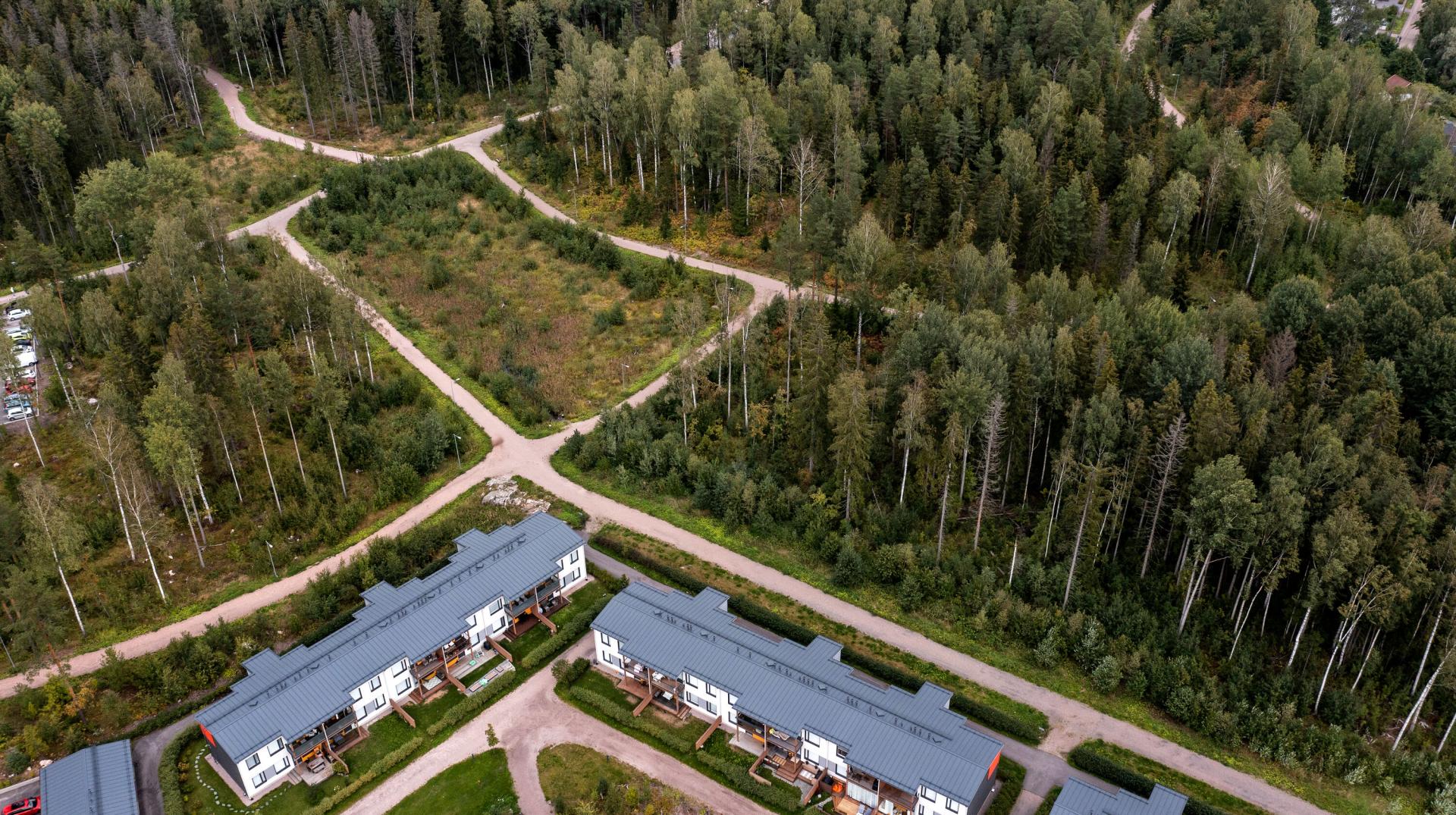
Fannynkallio residential area
Fannynkallio residential area is located on the northwest edge of the district. It was finished in 2019 and includes circa 100 apartments (see Fig. 10-12). The main design principle was a diverse vegetation that utilises the conveyed surface waters. Rain gardens, that infiltrate and filtrate, and lastly evaporate water through the ground layers were built on all yards. The topography of the yard was designed so that surface waters are directed to the rain gardens. Rain gardens consist of detention depressions, stormwater ponds and vegetation layers. If the ponds are filled, water is directed to stormwater pipes via an overflow structure. (Laitinen 2021).
Inhabitants of the Fannynkallio block have also planter boxes in use, which can be watered with surface water collected in containers and accessed via a hand pump. Stormwater allows for a functioning ecosystem when leaf mass is increased and there is more vegetation. (Laitinen 2021).
Stormwaters have been taken into account also in many surfaces and pavings. On walkways, permeable pavements were preferred instead of asphalt: stone ash, gravel and grass stone. Yard areas were covered with forest floor shrub-land transplant that retains water efficiently. (Laitinen 2021).
Green roofs that evaporate water were installed on low yard buildings and carports. The green roofs consist of a rubber bitumen layer to protect the water insulation, a growth layer and a thin layer of sedum plants on top (Laitinen 2021).
The Fannynkallio stormwater solution is a result from a cooperation of different types of planners, namely the garden/yard planner, geo technic planner and HVAC planner. The work was framed by the town plan of the City of Helsinki requiring the use of the Green Factor. (Laitinen 2021).
Helene Schjerfbeck’s park
Helene Schjerfbeck’s park is one of the most significant projects in the district (see Fig. 13-15). It has been built out of a natural, forested area of Hakuninmaanpuisto parkland, on the south side of the district as part of the nature-based stormwater management system with retention basins and meadow wetlands. The park acts as a flood meadow in which plant islands symbolise the palette colours of the famous Finnish painter Helene Schjerfbeck. The park exhibits the application of the latest knowledge of handling stormwater at the place of origin, and conveying them to wetlands and pools detaining the water. What is noteworthy, open water surfaces are made visible in the design and stormwater is a central and prominent element in the park. (Helsingin kaupunki 2015, 2016; Ilmasto-opas.fi 2014).
On the north edge of the park, the waters are conveyed through cascading rock formations towards the wetlands in the centre of the park. Water has also been brought to the kids’ play area. Water is conveyed to the wetlands through meandering channels that are partly wetlands-like or grass covered depressions, partly streams with gravel or rock surfaced streams. Wetlands are expected to increase the biodiversity of flora and fauna in the area. (Helsingin kaupunki 2015; Ilmasto-opas.fi 2014).
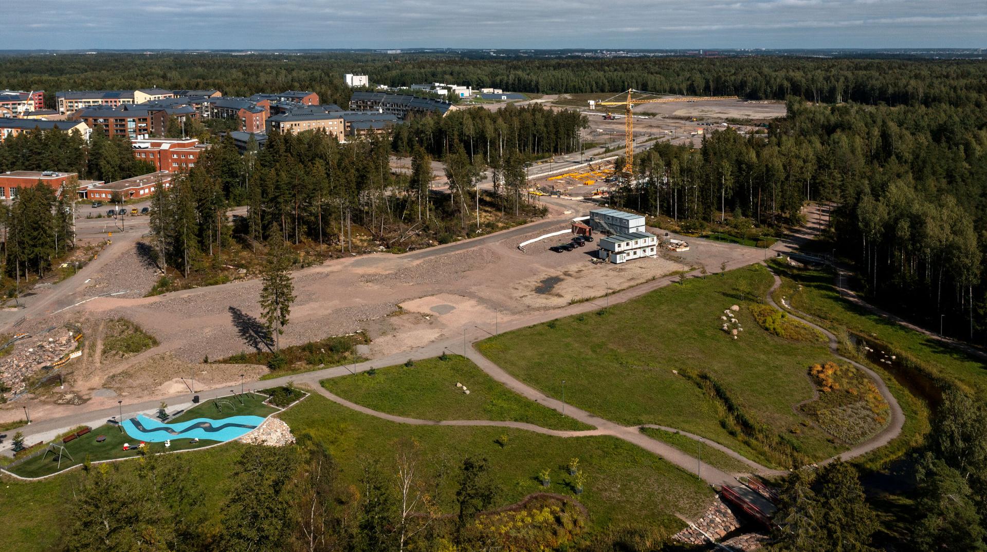
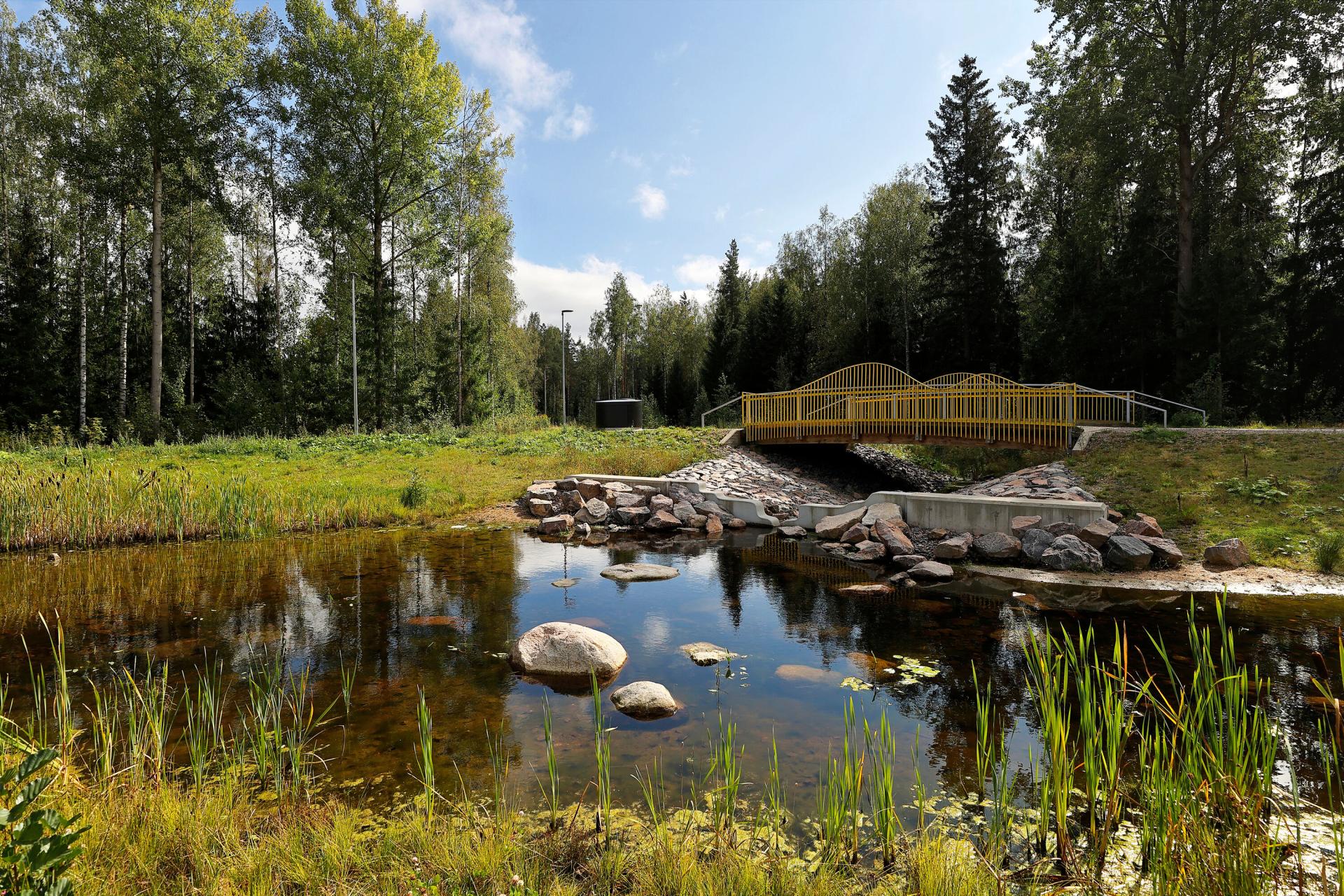
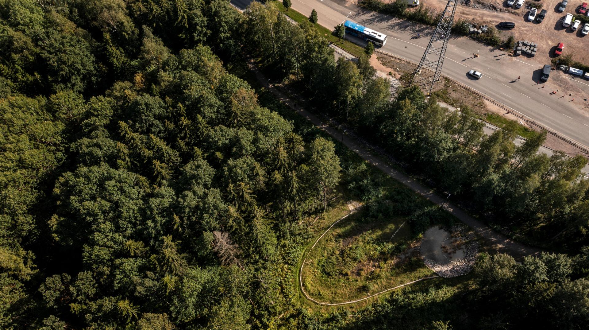
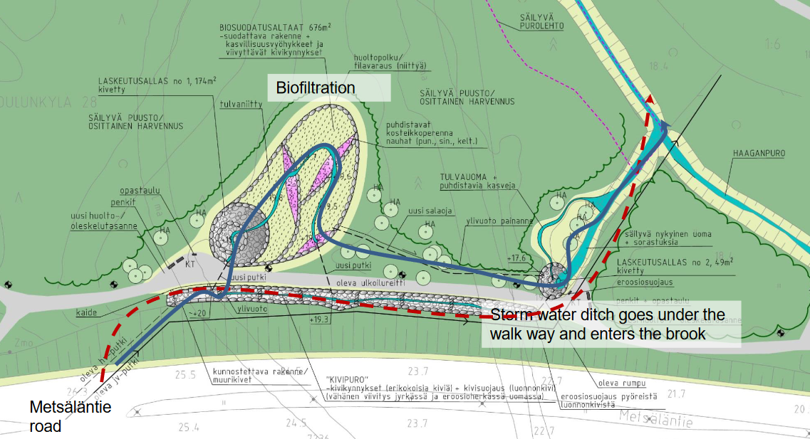
Maunulanpuisto park biofiltration area
Location: North Pasila, Central Park
Management / system type: detention & infiltration
Land use type: green or natural area
Built: finalised in 2015
Size: 700 m2 (biofiltration system (Peltosaari et al. 2020))
Drainage area: 15 ha (Rosqvist 2015)
Catchment basin: Haaganpuro brook
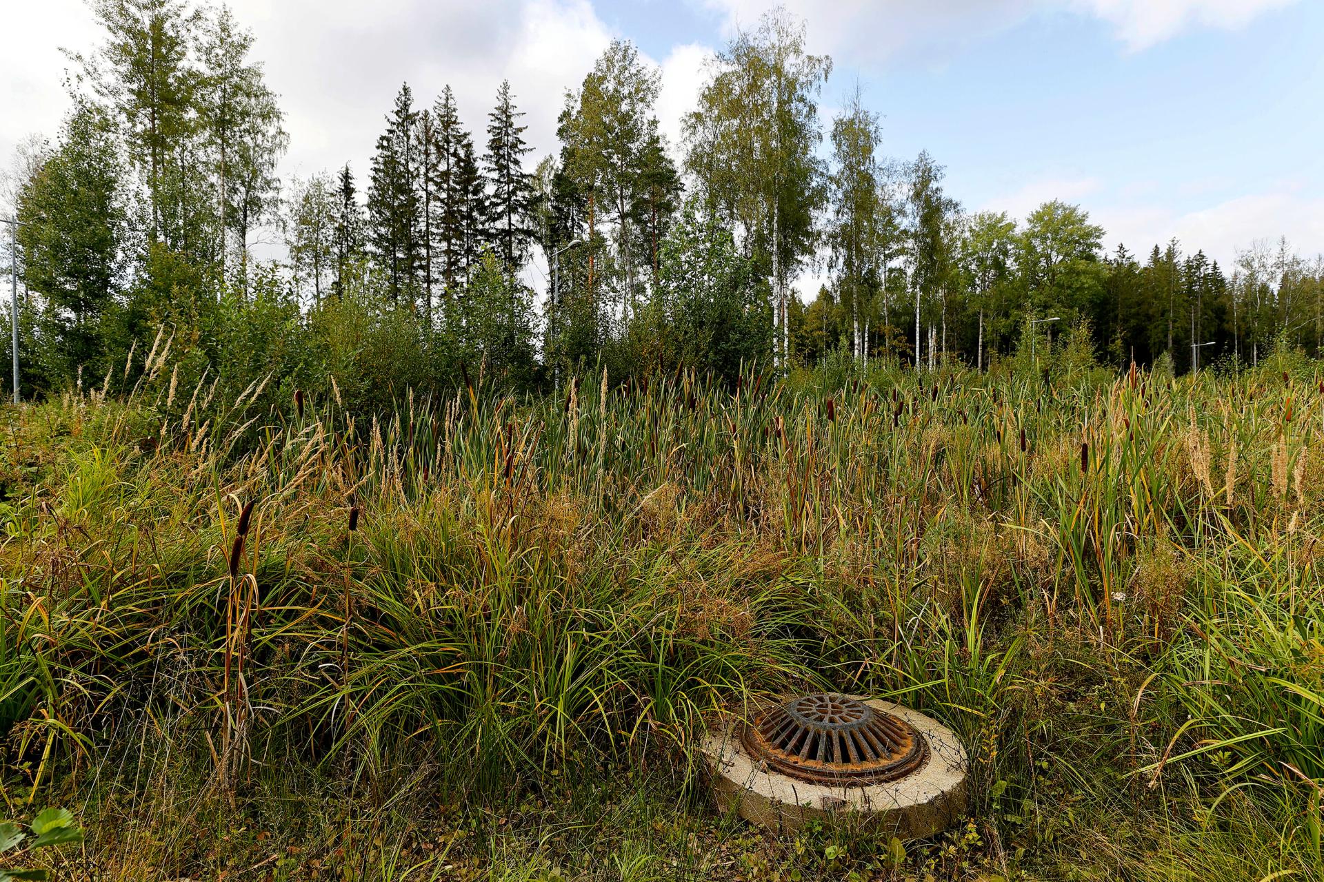
Description:
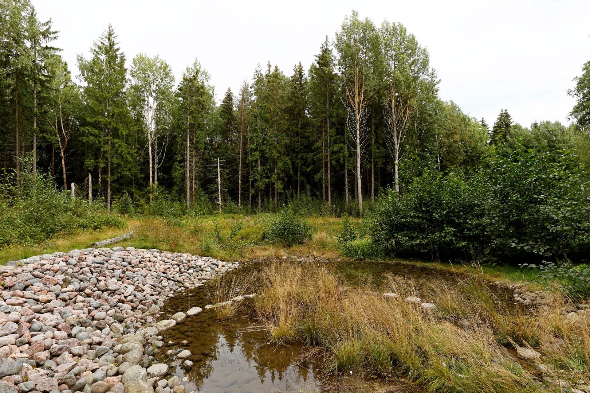
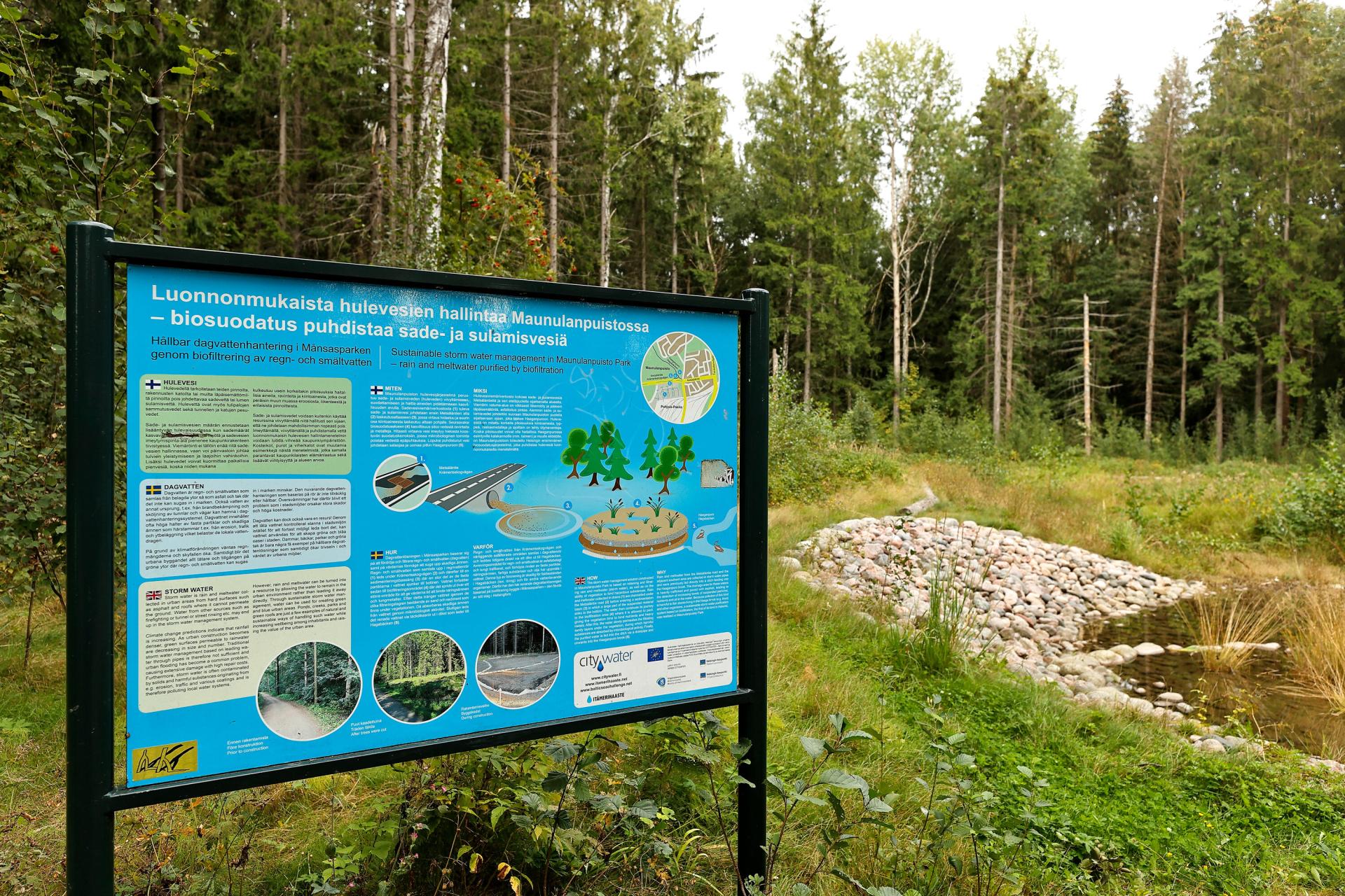
Maunulanpuisto park biofiltration area was built in 2015 to handle stormwaters from Metsäläntie road and former transport centre (Maaliikennekeskus) (Rosqvist 2015, Yleisten töiden lautakunta 2015) (see Fig. 16-19). It is located in a park that has been dedicated to recreation in the town plan, and the project was planned so that it would not harm the significant nature values in the area (Yleisten töiden lautakunta 2015). The purpose of the structure is to purify and detain stormwaters before they are directed to Haaganpuro brook using biofiltration as a natural stormwater management solution (Yleisten töiden lautakunta 2015). The Haaganpuro brook inhabits a breeding salmon population, which is extremely vulnerable for suspended solids carried e.g. by stormwaters (informant). The solutionalso acted as a pilot to test the biofiltration method as it was the first site of its kind in Helsinki at the time (Anonymous 2016, Yleisten töiden lautakunta 2015). The structure’s detention volume-capacity ratio is measured to about 85% once a year in 60 min rain, and about 100% once in 2 years in 60 min rain (FCG 2015).
The stormwaters collected from Metsäläntie road with heavy traffic and the industrial area – containing 74% impervious surface – were found to contain increased heavy metal and nitrogen concentrations as well as nutrients, PAH compounds, and occasionally oil due to oil leakages (Rosqvist 2015, Yleisten töiden lautakunta 2015). These were harming the fish stock (sea trout and whitefish) breeding in the Haaganpuro brook (Peltosaari et al. 2020, Rosqvist 2015).
This solution was realised within the “CITYWATER- Benchmarking water protection in cities” project (2012-2015) co-funded by the European Union LIFE+ programme and the Finnish Ministry of the Environment (Baltic Smart Water Hub 2017, Peltosaari et al. 2020). The stormwater management system consists of a sedimentation basin and a biofiltration area of planted vegetation (Peltosaari et al. 2020). Stormwaters collected from the road and industrial area are conveyed via pipes to the sedimentation basin that removes solids from the water by sinking them to the bottom (Baltic Smart Water Hub 2017). Then the water is directed to the biofiltration area that allows the water to pool, and that has been planted with vegetation (flooding meadow and wetland plants (Anonymous 2016)) binding nutrients and heavy metals. (Baltic Smart Water Hub 2017). The project benefited from previous research on vegetation, e.g. creeping red fescue was known to bind and utilise hydrocarbons; clovers PAH compounds, nitrogen and phosphorus; and willows heavy metals (Yleisten töiden lautakunta 2015). Water permeating slowly through sandy layers under the vegetation help purify the water even more when harmful substances are absorbed by microbial activity. The purified water is eventually fed into a ditch via a drainpipe and onwards to the Haaganpuro brook. (Baltic Smart Water Hub 2017). The site includes an information board to provide information on the function of the biofiltration area.
The construction costs were 220 000 € (Baltic Smart Water Hub 2017). At the outset of the project, around 5000 € /year (without VAT) was reserved for the maintenance (Yleisten töiden lautakunta 2015).
With regard to the maintenance, the structure requires annual checks to make sure it is functioning as planned. This may demand small repairs e.g. due to erosion and cleaning of rubbish. The vegetation is cut back when needed, or in early autumn (August/September). The basins need dredging to remove sedimented material circa every 3-5 years. Biofiltration layers must be renewed every 10 years. However, the need for biofiltration may decrease in the coming years due to former transport centre turned into living and business areas of which stormwaters will presumably be cleaner. (FCG 2015, Baltic Smart Water Hub 2017, Rosqvist 2015).
To monitor the functionality of the structure, water samples have been taken from the area infrequently: in 2017 every second month, and in 2019-2020 altogether six times. Based on this monitoring, it is determined that the biofiltration structure purifies well phosphorus and heavy metals (e.g. copper, lead and zinc) as well as PAH compounds and oil; it also effectively cleans suspended solids. No impact was found on nitrogen. (Baltic Smart Water Hub 2017 (discussion dated 2019), informant).
More information of the purification performance will be available in the beginning of year 2022; the City of Helsinki is currently investigating the water quality improvement performance of a few of its nature-based stormwater management solution sites, including Maunulanpuisto park biofiltration area. (informant).
There are some lessons learnt from the project. One should reserve 1-2 years for the planning stage, including setting aims, gathering key persons committing to the project, considering needed permits and assessments, budgeting, choosing a consulting company to plan the solution and informing local residents (Rosqvist 2015). It is reported that the planning of the stormwater management structure was made in tight cooperation with different actors: the group directing the work of the consultant consisted of members from the departments of public works, urban planning, building inspection and environment centre to consider different views and engage the actors to the project. The park plan of the stormwater management structure was presented to the residents in late 2014; they considered the protection of the Haaganpuro brook important, and cleaning of the stormwaters flowing into the brook was deemed necessary. (Yleisten töiden lautakunta 2015).
The construction stage can take 0,5-1 year and then one should have all essential construction related documents ready (such as construction plan, water service plans and map with soil and sediment information). Additional documents supporting the construction plan include cost estimates as well as a management plan for use and maintenance. (Rosqvist 2015).
Selected stormwater management solutions in Espoo
City of Espoo is the second largest city in Finland. It is characterised by an urban structure relying on five different centres and that is dominated by urban and detached house living close to nature. (City of Espoo n.d.).
Espoo’s population stands currently at 292 800 (2020). In 2030, there are estimated to be 47 300 more inhabitants, growing yearly by about 4700 inhabitants. By 2060 city is anticipated to grow in the fast growth scenario by 187 600 inhabitants. (Espoon kaupunki n.d.a).
The city has the lowest built-up area among the Helsinki Metropolitan Area cities, 20% (60% of the city land area is covered by forests (Espoon kaupunkisuunnittelukeskus 2020, see
Espoo’s first stormwater management program was accepted by the city council in 2012 (Espoon kaupunki n.d.b.). Already then, the program had an aim to move towards a more natural and integrated stormwater management and commit all city actors to these common goals. This aim is still considered to be timely and important. (Espoon kaupunkisuunnittelukeskus 2020). The 2012 program was updated in 2020 to take into account recent stormwater floods, increased research knowledge, experience gathered in the construction projects as well as changes in the legislation (Espoon kaupunki n.d.b). The update was supported by a thesis work (Airamo 2018).
The aim of the 2020 stormwater management program is that the stormwaters are managed in Espoo as a whole so that the water economy balance is maintained, the ecological state of stormwater receiving watercourses is improved and that the stormwaters cause damage neither to the health, safety and nature nor the attractiveness and functionality of the city. Stormwaters are regarded as a resource and an opportunity to create more sustainable and better environment. The program also aims to consider stormwaters in an integrated manner in land use planning and building. Natural stormwater management methods are used widely, and the stormwater management design and implementation are part of the normal development of the urban form. (Espoon kaupunkisuunnittelukeskus 2020).
The seven main objectives of the stormwater management program are (not in order of importance) (Espoon kaupunkisuunnittelukeskus 2020):
- Increasing the stormwater know-how, awareness and cooperation;
- Improving stormwater management and decreasing stormwater flooding;
- Preventing the damages caused by stormwater quality in the environment;
- Maintaining the urban environment biodiversity and improving the state of waterways;
- Securing the groundwater quality and maintaining its surface level;
- Preparing for climate change; and
- Advancing the benefit perspective of stormwater (such as recreational and practical use).
There are altogether 42 measures in the program, and each of them have been assigned a responsible body. These mostly include city departments and the stormwater working group. Measures are implemented in cooperation with HSY, Western Uusimaa’s rescue department and property owners. (Espoon kaupunkisuunnittelukeskus 2020).
The implementation of the program and related activities are directed by the stormwater working group that consists of relevant representatives of branches of administration. The group was formed as a result of the 2012 program’s goal to improve the internal cooperation in the city organisation. The working group does not decide stormwater related matters but oversees that the measures will be implemented, and the objectives are considered in the work of the branches of administration. It also monitors yearly the program implementation and ensures that the program is up-to-date. (Espoon kaupunkisuunnittelukeskus 2020).
Stormwater management design, building and maintenance are part of the routine work with no extra budget. It is however recognised that developing stormwater management requires additional resources both in terms of person years as well as investments and maintenance. Implementing the program measures is said to be easier in new areas compared to older, densifying areas, and good design is key in cutting costs. Also impacting costs and management options is that the natural stormwater management sites are disappearing along with urban planning. (Espoon kaupunkisuunnittelukeskus 2020).
Assisting with the integrated stormwater management is collecting and recording stormwater data in a user-friendly way. One of the program’s sub-objectives is to develop a stormwater database that includes information on catchment basin properties, sensitive waterways, implemented stormwater management structures and known flood prone sites. This complements the work of HSY in the HUTI project. (Espoon kaupunkisuunnittelukeskus 2020). A maintenance card file was developed as part of a student thesis work of Kymäläinen (2019) that supports in part the implementation of this sub-objective. It used as an example the stormwater card file of Vantaa and was tailored to suit the needs of Espoo’s green maintenance unit. This thesis work found that at the time Espoo had 46 finalised stormwater management sites and 16 sites were in development. (Kymäläinen 2019). The card file is intended to facilitate working together of planners and maintenance staff; it also offers ways to develop old operation models related to stormwater management structures’ maintenance and monitoring, as well as means for a more systematic maintenance (Kymäläinen n.d.). The maintenance cards have not really been updated since their development but they have been brought into a geographic information system directed to municipalities (Trible Locus) to be utilised (informant). Figure 27
The stormwater management program presents operational principles for all the branches of administration to apply in order to meet the program’s objectives (Espoon kaupunkisuunnittelukeskus 2020).
The stormwater management program and its objectives are supported by Espoo’s strategy (Espoo-tarina, i.e. The Espoo Story), as well as the sustainable development program (Kalliala and Lehikoinen 2019).
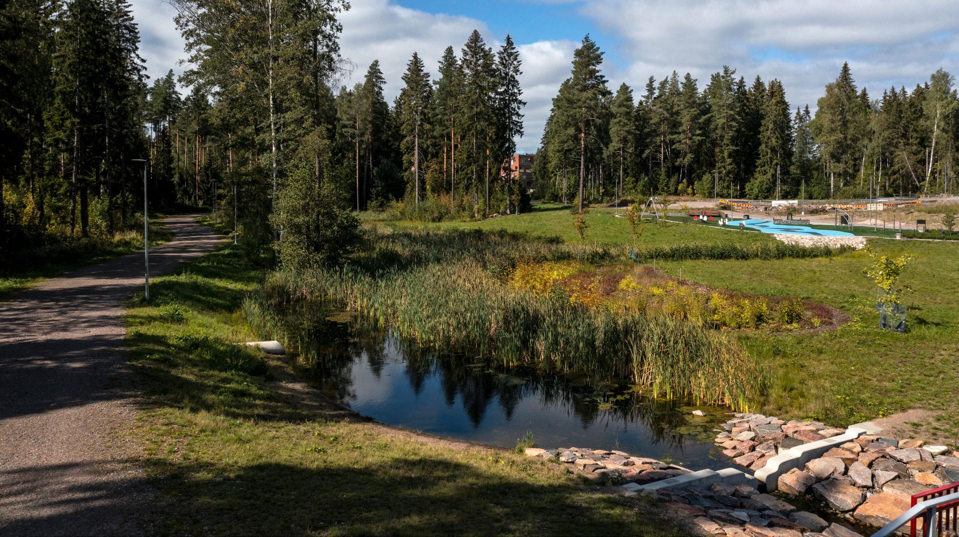
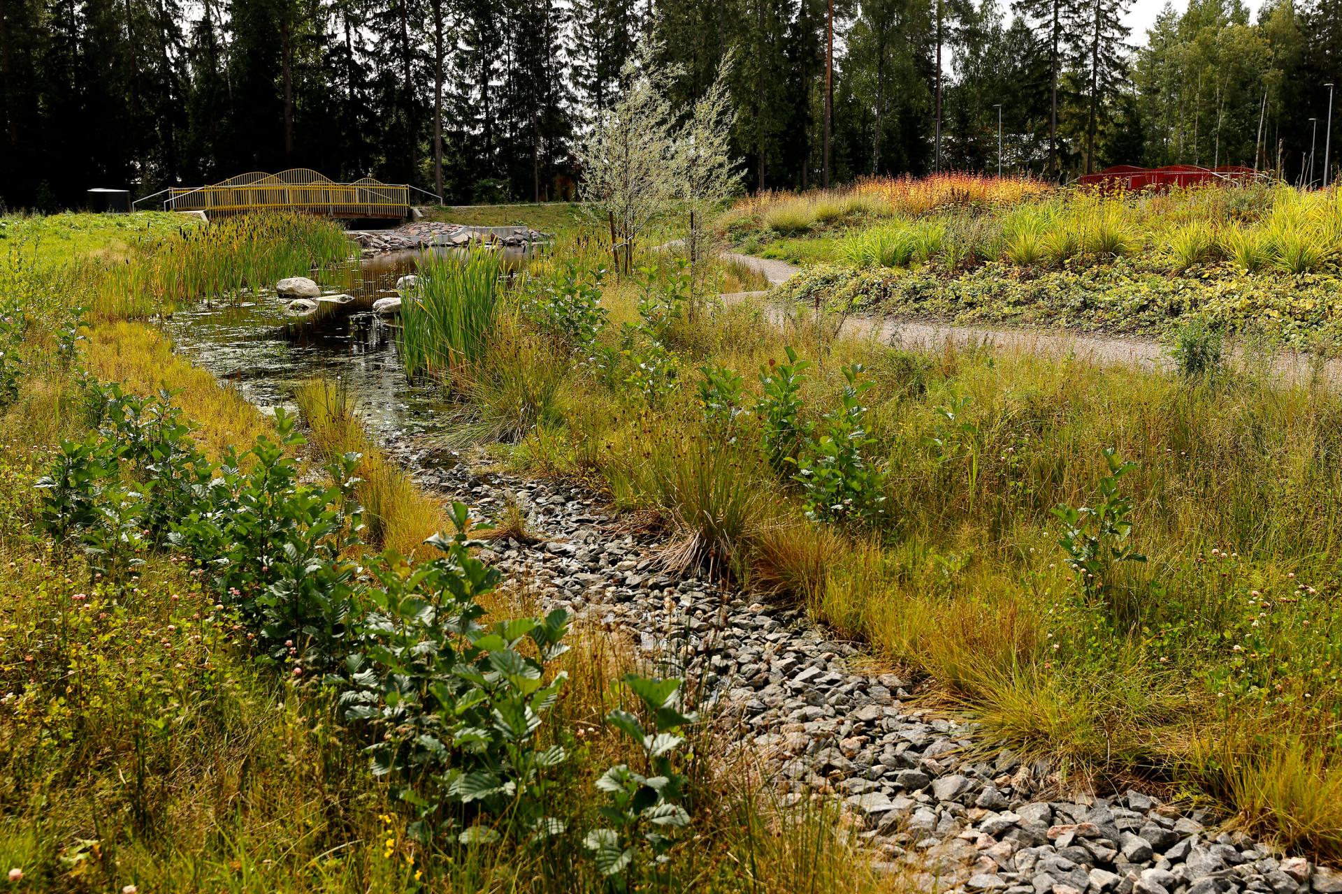
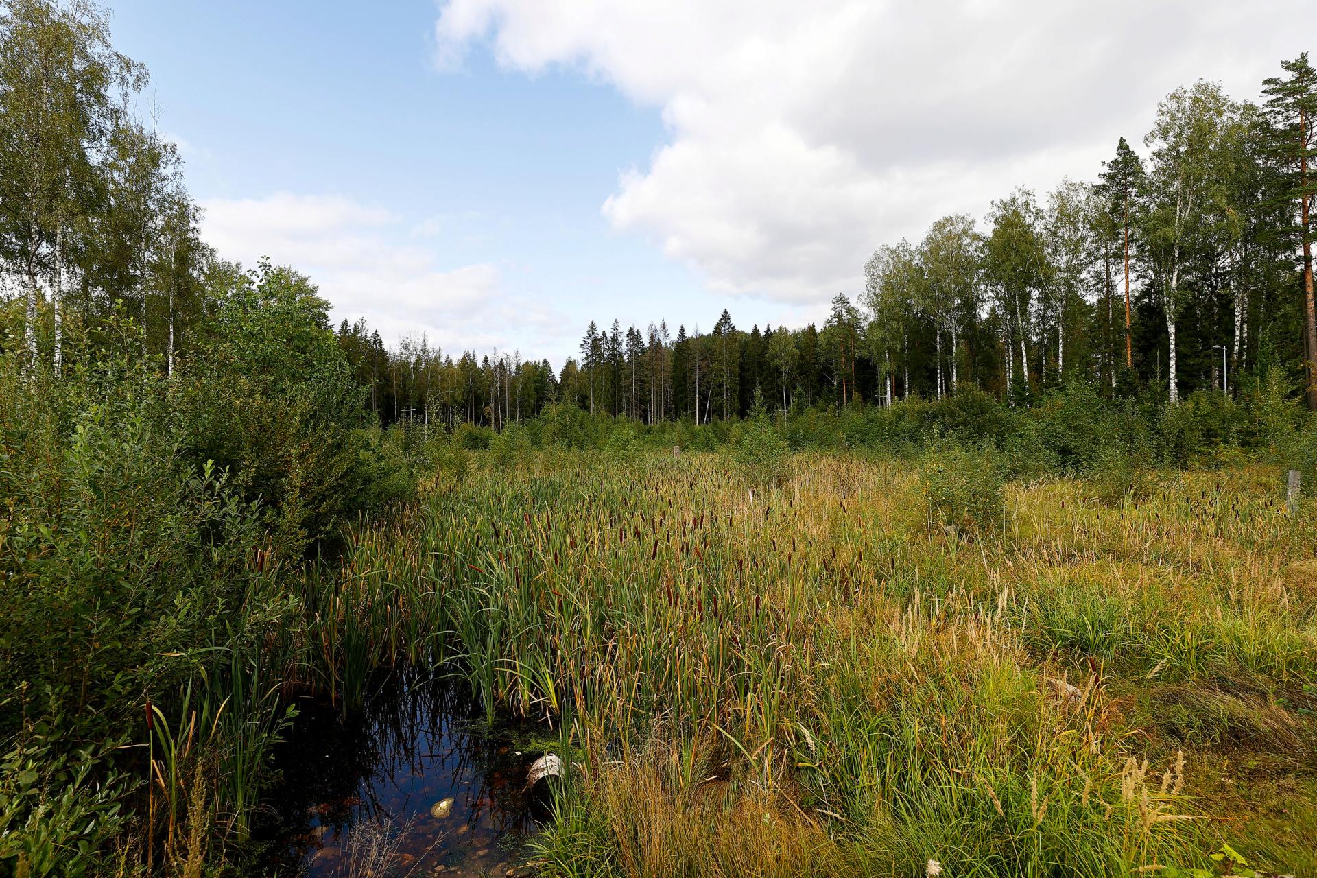
Huhuilijanpuisto park wetland
Location: Lintuvaara, Helmipöllönmäki
Management / system type: detention and infiltration, conveying
Land use type: Green or natural area
Built: 2013, repaired in 2016
Drainage area: Wetland receives stormwaters from the forest on the northside and a few nearby streets (Helmipöllönkatu, Lintulaaksontie, Korpraalintie) (informant).
Catchment basin: Monikonpuro stream
Description:
This site is situated in eastern Espoo in a forested park with outdoor paths, next to a residential area of single-family houses and apartment blocks (see Fig. 21-23). It is actually a ditch that was built to go through a forest, and the intention was that the flooding water could rise into the forest area. However, after building the structure, it was noticed that water remained high, and the majority of the trees had died. It also decreased the attractiveness of the area. The reason was that the stormwater well blocked easily due to forest litter. (Kymäläinen 2019).
In 2016, the site was planned repair measures and the implementation was starting at the end of the year. It was deemed necessary to repair the well system of the detention area so that the water level would be lower and that would thus create better conditions for the vegetation. In fact, the same issue was found at another, connected site nearby. Repair measures included lowering stormwater well and subsurface drain levels at both sites. Repair costs were estimated 7000-10 000€ together for both sites, and were planned to last for about a week. (Herttua and Hell 2016).
After these measures, the status in the autumn 2021 was that the structure appears to be working well though the brushwood needed to be cleared as part of the routine maintenance. The city informant admitted that it is typical of these types of stormwater management sites that they do not form a functioning whole right away. This can serve as a learning for others.
The intended purpose of this detention area is that the basin is filled momentarily after the rain and this reduces flood risk downstream. The water is purified when detained, and the basin is slowly emptied. Therefore, stormwater basins usually have relatively little amount of water. (informant).
The maintenance objectives of the site include making sure that the site is functioning as intended and that there is no human-related litter. Water can rise only temporarily and only to an area designated to it. The wetland should not include any harmful plant species. The site should be checked and evaluated in the spring, after snow melting and heavy rains. (Kymäläinen 2019).
Merituulentie road biofiltration swales
Location: Niittykumpu district, Suur-Tapiola
Management / system type: detention & infiltration
Land use type: densely built-up area / developing (or rural) area
Built: 2018
Drainage area: Gräsanoja creek 24,2 km2, Nässelkärrinoja creek 2,15 km2
Catchment basin: Gräsanoja creek
Description:
The Niittykumpu area has been built mostly in the 1970s, and it is to double its inhabitants from 5000 to 10000. It has highly impermeable surface area, 45-55%. The installation of bioswales on both sides of the Merituulentie road was part of the decentralised stormwater management plan of Niittykumpu. This plan is estimated to be implemented in 2018-2024. The aim of the plan is to reduce flow peaks, as well as to slow down, convey and purify stormwater, with different types of green or nature-based structures. The objective of the flood protection is that the rains occurring once in every 30 years do not cause considerable harm. It is estimated that flow peaks can be reduced by 30% in Niittykumpu drainage area by implementing the stormwater management measures in the plan; also stormwater quality is expected to improve, and therefore also the water quality of receiving waterways in Gräsanoja creek and Suomenlahti bay. (Kalliala and Lehikoinen 2019).
The Espoo Story supports utilising research in new, experimental structures as it describes the city as a responsible pioneer. This in turn means, among other things, having courage to do things in a new way. (Kalliala and Lehikoinen 2019, Kerkkänen et al. 2019).
The swales were built in 2018 on both sides of a busy road, with about 15 000 cars passing per a weekday, in a densely built-up area (see Fig. 24-27). Significant part of the traffic related substance load – such as phosphorus, metal and PAH compounds – are conveyed and accumulated next to the road. Therefore, the road’s stormwaters are optimally treated with biofiltration. (Kerkkänen et al. 2019).
The objective of the bioswales is to manage the quantity and quality of stormwater, and to reduce the nutrient and metal load to the Gräsanoja trout creek were the road's stormwaters flow, and that has flooded in recent years. The aim is to manage cloudbursts occurring every three years. The intention was also to examine the functioning of biofiltration in purifying stormwater. (Kerkkänen et al. 2019).There are four different types of bioswales. Western bioswales are sand-based biofiltration structures whereas the eastern structures were added biochar as a filtration medium. North-side bioswales have perennial plants and paving while the south-side bioswales have been planted bushes and have curbside inlets. (Kymäläinen 2019). Sand has been traditionally used in stormwater filtration due to its properties to retain well most impurities and nutrients (Eckhart et al. 2017 cited in Kerkkänen et al. 2019). Biochar is used to retain phosphorus; water is also aimed to be retained more compared to a normal growth platform (Kerkkänen et al. 2019).
Research (part of the Hule S&C project) included monitoring of the functioning of the systems in 2018, including measuring the water flow and turbidity of incoming and outgoing stormwater (these are indirect quality parameters). Also, a new continuous measurement device was installed to demonstrate monitoring of concentrations of chemical elements. In addition, one of the sand-based structures was taken water samples during two rain events in November. (Kerkkänen et al. 2019).
It was found that during rain events, total suspended solids, phosphorus, chromium, copper and zinc concentrations exceeded Swedish threshold values indicating treatment need (Finland does not have quality criteria for stormwater). However, the (sand-based) biofiltration structure was found to significantly decrease the concentration of several substances in the stormwater, e.g. suspended solids 97%, total phosphorus 63%, and total chromium 76%. (Kerkkänen et al. 2019).
The learnings from this site include(Kerkkänen et al. 2019):
- Biofiltration suits especially well to retain harmful substances that are bound to suspended solids.
- Dry long periods should also be prepared for, not only cloudbursts. Vegetation may need a lot of water in the first year, and hence the structure retains more water also.
- To obtain a good understanding of how the structure functions, a long measurement period in different weather conditions, seasons and in the course of vegetation growth is needed.
- Maintenance need and cleaning frequency of structures must be determined.
- Biodiverse vegetation is searching for its place in correct moisture conditions. Structures and vegetations need to withstand various weather conditions.
- Build structures in the autumn so that they saturate with water in winter and vegetation can start to grow in the spring.
As it can be seen from the photos taken in August 2021, vegetation is doing well on the north
The maintenance card specifies, among other things, that the vegetation needs to be cared for so that it can grow as planned; pavements are cleaned during street cleaning, and – as in the case of Huhuilijanpuisto park site – the bioswales ought to be checked and evaluated in the spring, after snow melting and cloudbursts. (Fig. 27, Espoon kaupunki, n.d.c, Kymäläinen 2019).
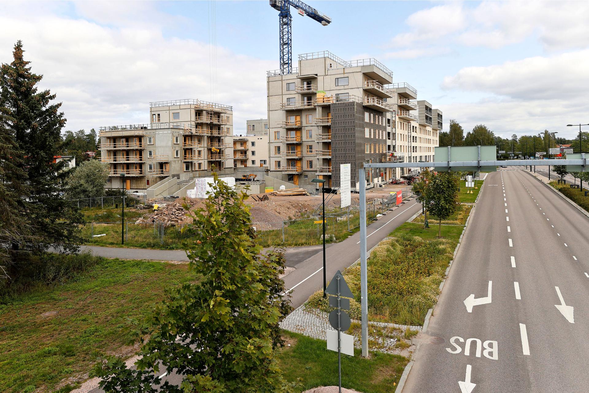
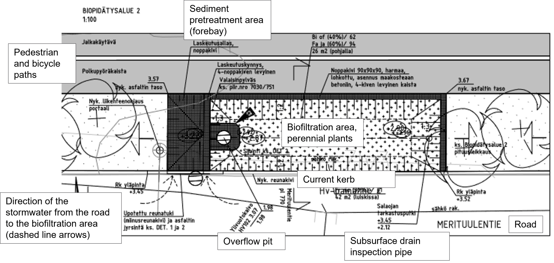
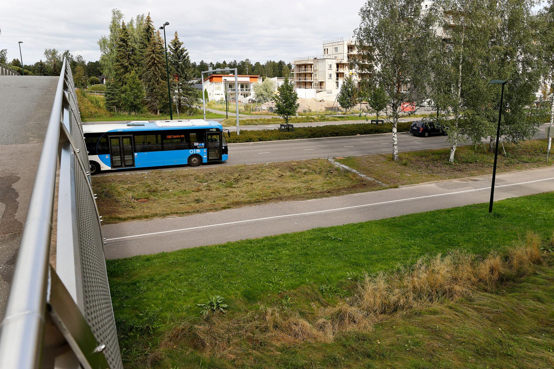
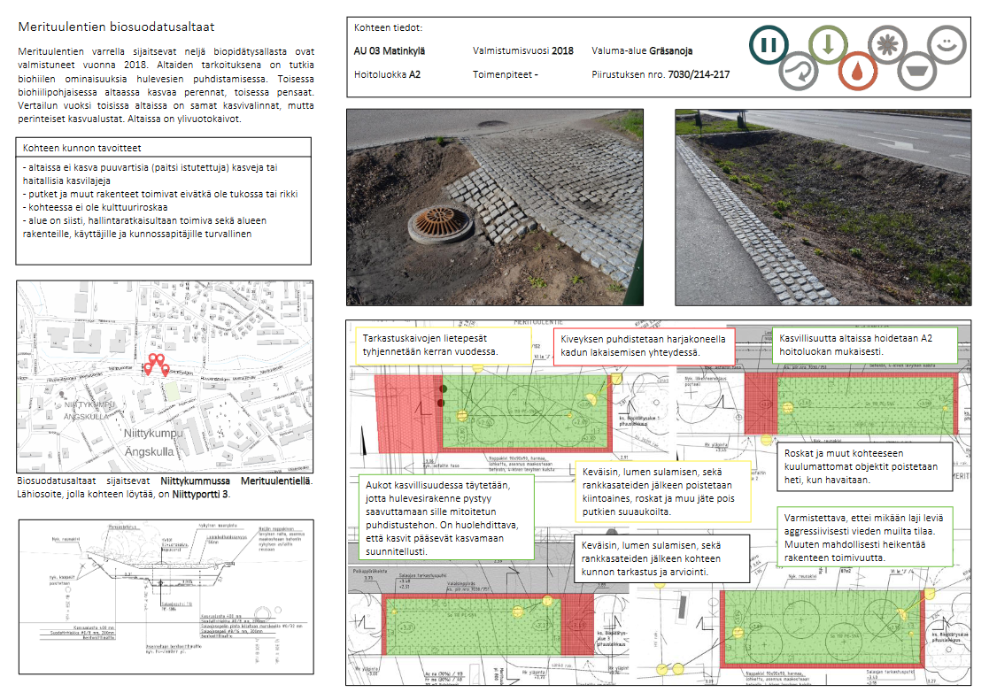
Selected stormwater management solutions in Vantaa
City of Vantaa is Finland’s 4th largest city with more than 237 000 inhabitants (2020); it grew the most of all Finnish cities that year. It has an international airport and consists of seven major regions (City of Vantaa n.d). In 2045, Vantaa’s population is estimated to grow to 322 000-348 000, depending on the scenario (Mänty and Riihelä 2021).
City of Vantaa has almost one-third (29%) of its surface area covered by impermeable surface (Figure 28). It includes 3 out of 4 land use types defined in the RAINMAN project as it does not have any historical areas.
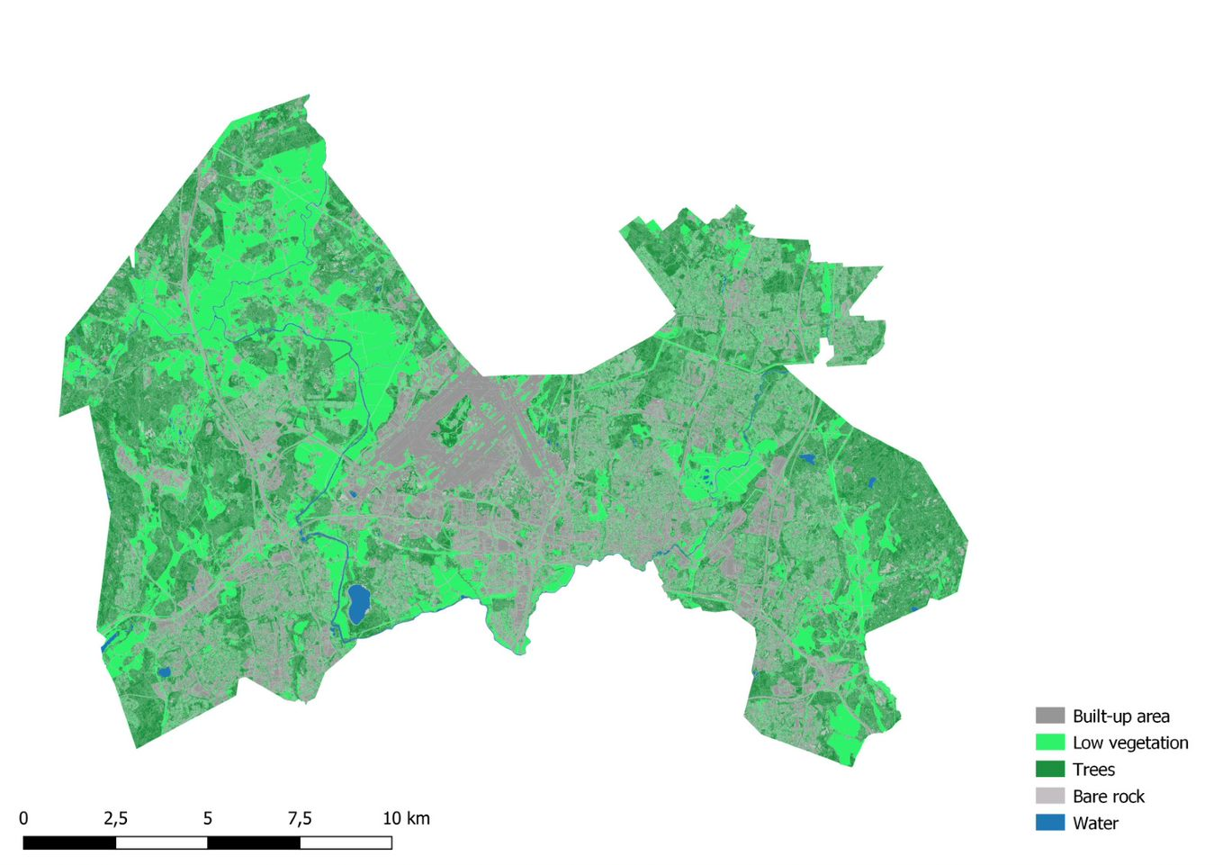
Vantaa developed its stormwater management program in 2009; it was only the second of such a program in Finland at the time (Lehikoinen 2015, Vantaan kaupunki 2009). It was complemented by a stormwater management operational model document in 2014 (Vantaan kaupunki 2014a). A guide on stormwaters of the built environment and roof vegetation was published also in 2014 (Vantaan kaupunki 2014b).
The operational model was developed as a set of instructions to those who direct the construction in Vantaa. It guides the planning and building according to the principles defined in the 2009 stormwater management program. It applies to all new building as well as infill development in the city area. The operational model mainly concerns business, industrial and public buildings as well as blocks of flats of which plots have less permeable surfaces than single detached house plots, and thus are likely to have more issues with stormwater management. The operational model advices planners and builders on stormwater management methods, and planning principles; and showcases some of the stormwater management sites in the city. (Vantaan kaupunki 2014a).
The 2009 program includes the objectives and measures for integrated or holistic stormwater management, as well as the priority order of stormwater treatment. It outlined that stormwaters need to be primarily treated locally and the natural management is adopted as a common planning principle. (Vantaan kaupunki 2009, 2014a).
The main objectives of the stormwater management are (Vantaan kaupunki 2014a):
0. Reducing the amount of stormwater forming.
1. Managing the quality and quantity of stormwaters locally at the source.
2. Managing stormwater floods and preventing flood damages.
3. Protecting the quantity and quality of groundwater (clean and purified stormwater are infiltrated at the source).
4. Advancing waterway protection and urban nature’s biodiversity.
5. Preparing for the future changes in climate and land use resulting in growing amount of stormwater.
In addition to the structures managing the quantity of stormwaters, the City of Vantaa aspires to increasingly consider also quality management (informant). Both of the selected sites in this report include biofiltration area pilots, and are located on the east side of the international Helsinki-Vantaa airport.
Vantaa is a pioneer in planning a policy for vegetated roofs. If the policy was realised, it would one of the first of its kind in Finland. The city is still discussing whether the policy should be accepted – meaning that the city would be required to apply the policy in its own projects – or it should rather act as a recommendation. While it comes down to the costs, the policy is argued to lead to savings that would be largest in terms of stormwater management as the vegetated roofs absorb water and detain its flowing into the sewer. The vegetated roofs are considered to result in various other benefits such as reducing the heat island effect, maintaining biodiversity, improving air quality, increasing attractiveness of the urban environment, and allowing everyone – also movement impaired – to have green close to them. Moreover, they are protecting roof structures, and when insulating in winter and cooling in the summer, they help reduce energy use and muffle the sound. (Hovi-Horkan 2021).
Kivistö centre is a new developing district in Vantaa that envisions vegetated roofs everywhere in 2050, and that every roof is in use (Hovi-Horkan 2021, Vantaan kaupunki 2021a). Also various other nature-based solutions have been planned or already adopted in the area, such as biofiltration, permeable surfaces, urban farming and a stormwater basin (Rehunen et al. 2021). Water is intended to be a visual and functional element that is visible in urban spaces, it is used as part of an irrigation system for urban farming, and car parking is centralised in designated parking facilities. Therefore, there are more permeable surfaces for urban farming and nature-based stormwater management. The interim town plan of the Kivistö centre and its stormwater assessment have been used as a starting point for a multi-objective framework on nature-based planning solutions; it helps to recognise multiple benefits and objectives that enable them. (Vantaan kaupunki 2021a).
Murronpuisto Park in Kivistö has been planned as a stormwater park. A stormwater basin has been built in the park to detain Kivistö centre’s stormwaters. While this site was not selected as the one showcased in this report, it was brought to attention that it has not functioned as intended and the basin has retained too much water. This is because the pipe discharging the water from the basin has been at a too high level. (informant).
Similar to Helsinki, Vantaa has used a Green Factor-like tool in town planning since 2017, and from 2020 it is applied in every town plan. Vantaa calls it the “Green Efficiency” method that is essentially the same as Helsinki’s Green Factor tool. (Vantaan kaupunki 2020). Part of the green and blue infrastructure in Kivistö area has been planned by using the Green Efficiency tool. Stormwater management structures like a rain garden or a wetland raise the Green Factor or Green Efficiency. (Sanaksenaho 2015).
The city has developed a maintenance card file – inspired by that of Tampere – that includes information of the stormwater structures’ location, basic information and the timetable for maintenance. Every new stormwater management structure is developed a maintenance card. At the moment the information is in Excel-table form, but the idea is to publish it in the city’s own database and /or to be included to the HUTI database (first data like surface area, type, location etc.; qualitative and monitoring information would be added later), and more actively utilise it in the monitoring also. Maintenance costs have also been estimated for the next 5 years. All around city’s 50 stormwater management structures in public areas are intended to be checked yearly in September or October, and in this check next year’s maintenance and repair sites are proposed. Long-term check is to be carried out to about 4-8 structures per year. Maintenance measures in each site are to be reported in the electronic maintenance book that is kept up-to-date. (Auvinen 2021, Vantaan kaupunki 2018, 2019, 2021b; informant).
Koisotie road snow reception area, biofiltration area and wetland
Location: Tikkurila central park, Koivuhaka district
Management / system type: conveying, detention & infiltration
Land use type: densely built-up / green or natural area
Built: Planning in 2011, built in 2013 (Vantaan kaupunki 2021b)
Surface area: 1000 m2, water surface area 1630 m2 (Vantaan kaupunki 2018, 2021b)
Catchment basin: Kylmäoja stream (Vantaan kaupunki 2021b)
Drainage area: 19 km2 (Pihlajamaa 2010)
Description:
The aim of the Koisotie road's snow reception area's planning process was to establish a wetland area that retains and purifies impurities of the water originating from the snow reception area, and to prevent the load caused by the meltwater in the receiving Kylmäoja stream (see Fig. 29-32). In addition, the purpose was to control the water flow so that a year-round water feature is created in the Tikkurila central park. The wetland area includes a stream on the west side. (Kuntaliitto 2012, Pihlajamaa 2010).
In 2010 it was estimated that the snow reception area receives in an average winter about 5000 truckloads of snow, or about 50000-75000 m3 of snow. This snow contains considerable amounts of impurities that have been considered in the planning phase. The snow stacking area is relatively small considering the drainage area so the treatment of the meltwater and the whole drainage area management have been handled as separate systems. (Siren 2010 cited in Pihlajamaa 2010).
The site is divided into two parts with different characteristics: the actual snow reception area, and its rampart and park area. The park area was built with water features that serve the purposes of cleaning the dirty waters from the snow reception area, and acting as stormwater basins, from which the water flows to the Kylmäoja stream. The water features and plants participating in the purification of the meltwater also enhance the landscape through which outdoor paths are crossing. (Kuntaliitto 2012, Vantaan kaupunki n.d.).
The park includes a biofiltration area that is designed to purify the snow melt water of the reception area. That water is collected via inclinations to the ditches on both sides of the area, and directed to the sand and oil separation system and then onto the biofiltration area. The purpose of the biofiltration area (0,4 m deep basin) is to treat and detain snow reception area’s stormwaters by filtrating them through layers of strata. 90% of the surface area is covered by wetland plants, and those have been selected based on their abilities to withstand both moisture and dry conditions as well as high salt concentrations. The best purification effectiveness is reached when the plant number is high, the number of species does not matter as much. Plants include common reed, common club-rush and narrowleaf cattail. The stormwater that has gone through the biofiltration area (sand, humus, plant base) is directed to the wetland through an underground drain. The water permeability of the biofiltration area filter media needs to be high but it also needs to have the ability to sufficiently retain water and nutrients for the plants. (Kuntaliitto 2012).
Flood plains next to the stream have been planted e.g. meadow plants. Slopes and side of the stream have been planted wetland perennials, mainly domestic natural plants withstanding occasional water level rise. These plant species include European water-plantain, marsh spurge, yellow iris and purple loosestrife. (Kuntaliitto 2012).
The biofiltration area and the wetland appear to have been functioning well. The water outflowing from the biofiltration area has been determined clear(Jormola 2019). Only one water sample is known to have been taken four years ago, to check for heavy metals (Cd, Cu, Pb, Ni ja Zn) of the inflowing and outflowing water in the biofiltration basin. Most of those heavy metals were found to be retained by the biofiltration area. While this test shows in part the structure’s functionality, only a few tests do not yet tell much, says one of the city informants.
According to the maintenance card of the Koisotie site, the yearly monitoring includes checking the condition of the biofiltration basin visually, repairing edges if needed and making sure stormwater can filtrate through. Planted vegetation is also checked in September-October (that it is robust) or in the spring after the snow has melted. Also, the sand and oil trap wells are checked and cleaned. In the long-term maintenance, the vegetation (reeds) is cut back every five years. The subsurface drains are rinsed from sand and the functionality of the biofiltration area is checked, and surface layer is changed as necessary. (Vantaan kaupunki 2018).
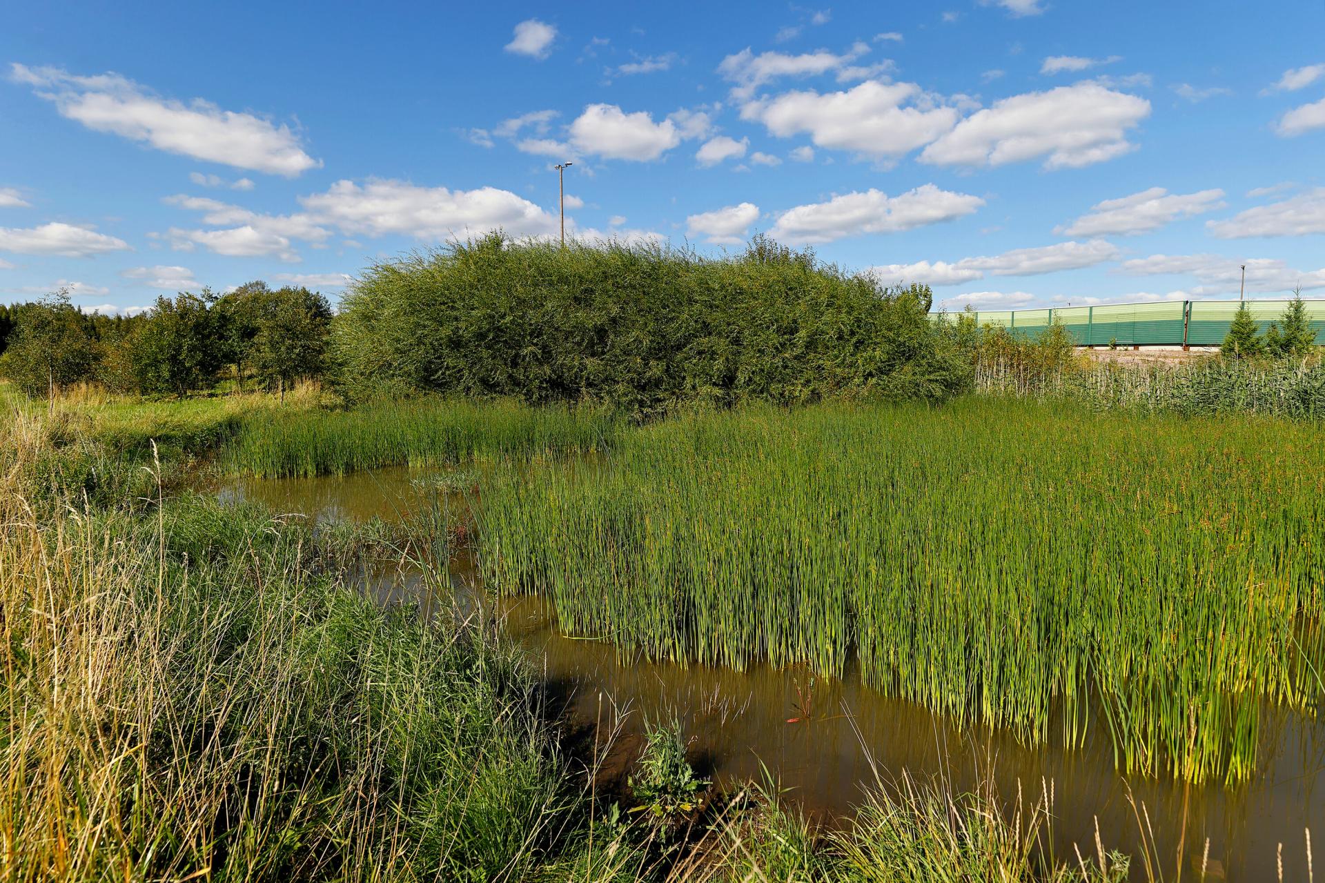
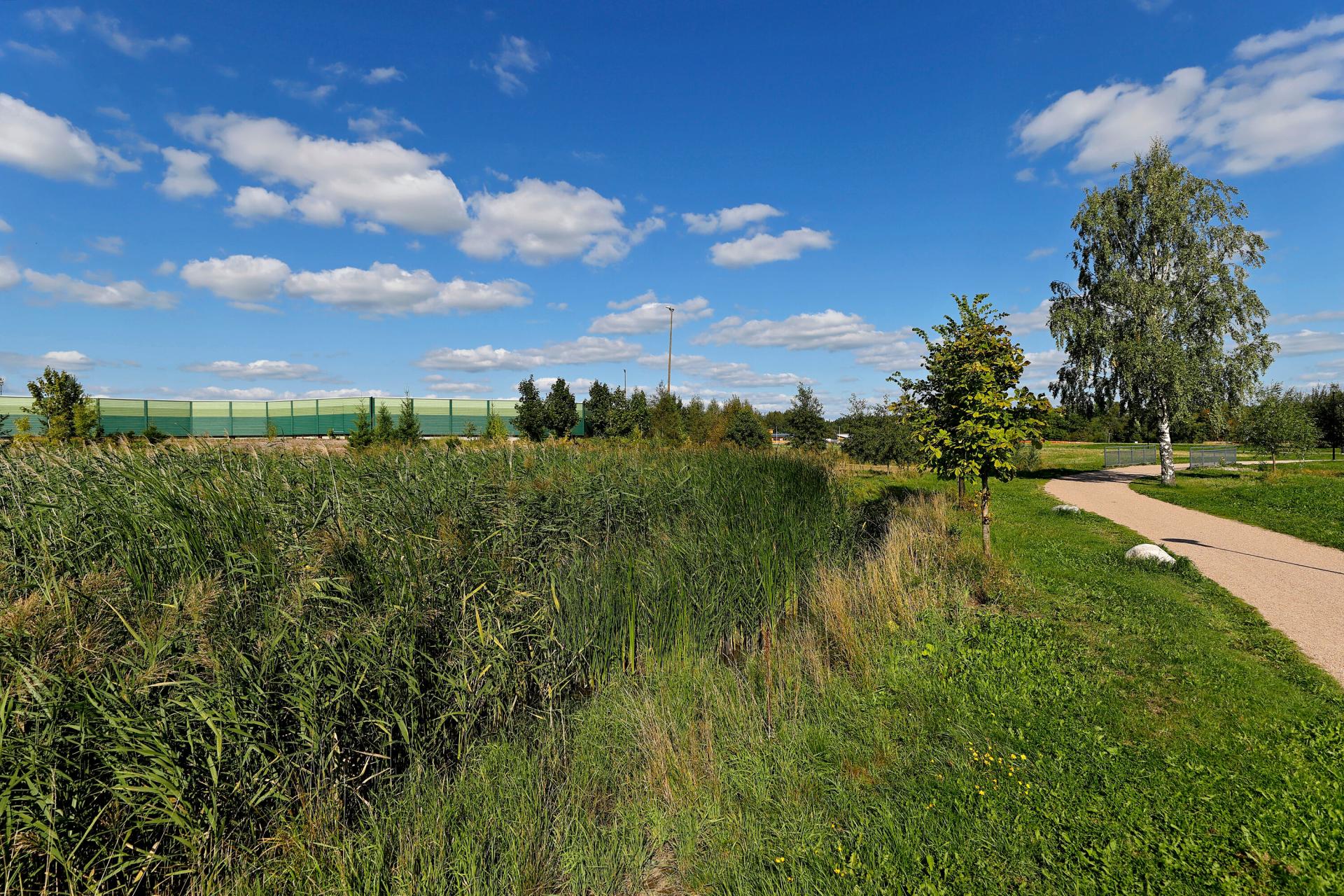
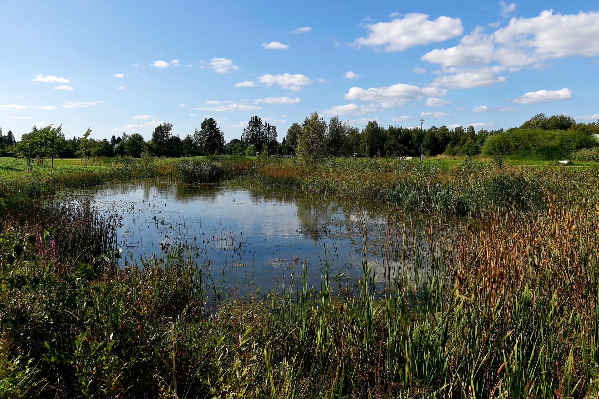
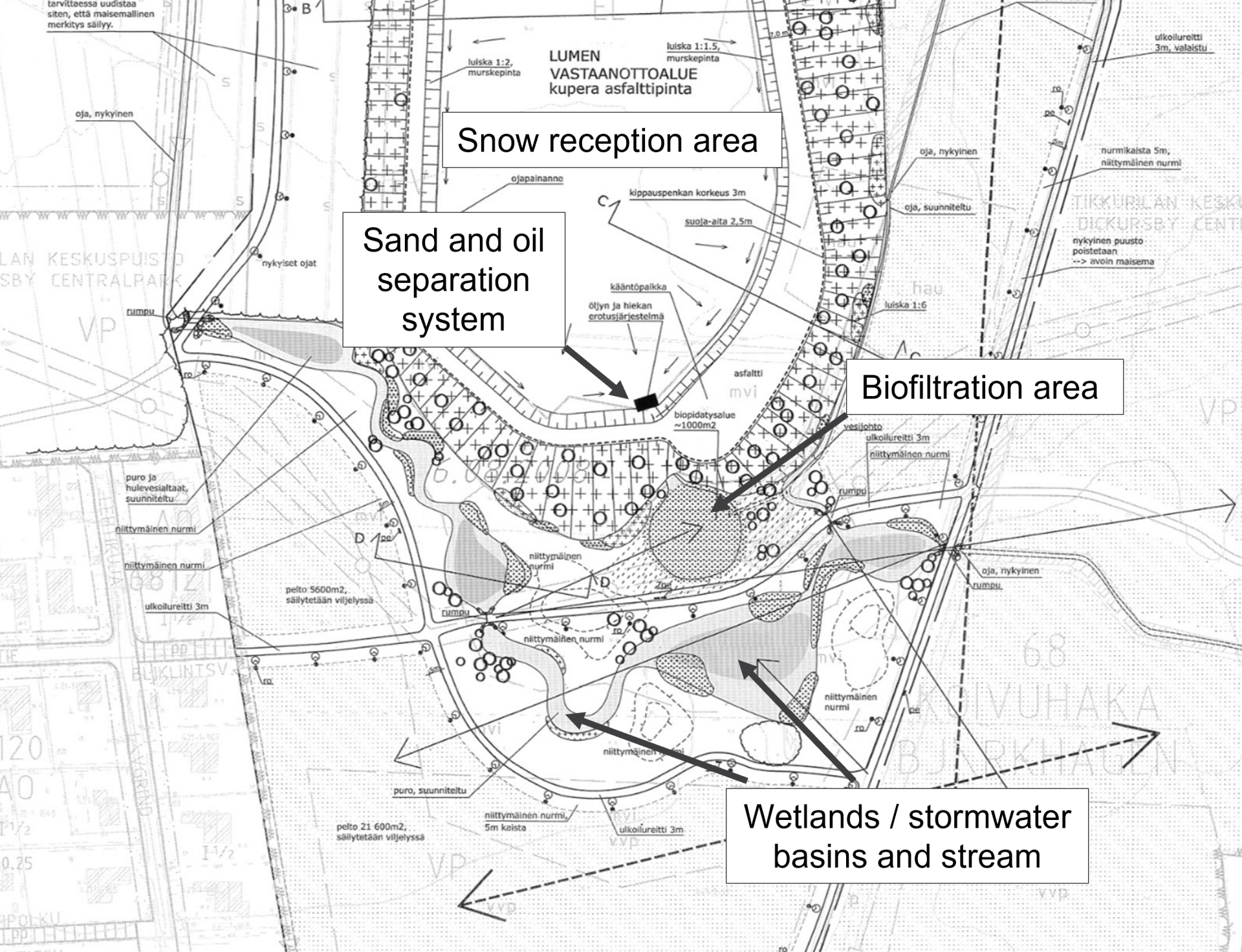
Meiramitie road biofiltration swales
Location: Koivuhaka district
Management / system type: detention & infiltration
Land use type: densely built-up
Built: construction works 2013, bioretention areas were finalised in 2014 (Lehikoinen 2015, Vantaan kaupunki 2021b)
Surface area: 210 m2 (Vantaan kaupunki 2021b)
Catchment basin: Kirkonkylänoja stream (Vantaan kaupunki 2021b)
Description:
Meiramitie road’s biofiltration or -retention system was built during the road renovation works. Meiramitie is a busy collector road situated in an industrial area and receives both heavy and commuter traffic. The road needed refurbishment e.g. in terms of street structures and stormwater management as the stormwater stood on the street. Five biofiltration areas (or bioswales) and two green areas were built in between the driveway and the pedestrian and bicycle path (see Fig. 33-35). (Ilmastotyökalut.fi 2014, Lehikoinen 2015).
While there are no current traffic numbers, it is estimated to increase: in 2030 the morning peak may see up to 2500 vehicles passing, the evening peak up to 3900 vehicles (Lehikoinen 2015). These traffic numbers are still considered relatively low with regard to impact of traffic on the pollutants, nutrients and chemical oxygen demand (Jokela 2008).
The bioswales receive only half of the road’s stormwater due to the road inclining on both sides. On the south side of the road, stormwaters are directed with road levelling onto the paved depressions retaining the water. On the north side, stormwaters are directed to a stormwater sewer with the shaping of the terrain. (Lehikoinen 2015).
The drainage area of the bioswales consist of stormwaters of the road, pedestrian and bicycle path, roadside and actual biofiltration; also the nearby Niittytie road’s stormwaters are partly directed to Meiramitie road to be treated. Stormwaters are then directed to Kirkonkylänoja stream via Niittytie road’s ditch, and into Keravanjoki and Vantaanjoki rivers. (Lehikoinen 2015).
The structure of the bioswales is almost the same in each of them: growth layer on top, then sand, crushed stone and crushed aggregate and the subsurface drain (see Fig. 35). The filter fabric surrounds the whole structure. Stormwaters are directed with road levelling onto the paved depressions retaining the water, which collect the suspended solids and rubbish conveyed with the stormwater. Moreover, two different types of kerb types – zero level and openings in the kerb – were tested to determine which solution directs the stormwater more effectively. For overflows, biofiltration areas were installed covered stormwater pits. The structures are measured to withstand rain lasting for 10 minutes, with an average rainfall intensity of 150 l/s per hectare. (Ilmastotyökalut.fi 2014, Lehikoinen 2015 ).
The bioswales were selected different types of vegetation that are easy to maintain, withstand the scorching sun, road salt and occasionally standing water (lyme grass, skunk currant, meadow foxtail and false spiraea). Tree species selected on the road were common alder (withstanding wet conditions and increasing the nitrogen content of the ground) as well as silver birch and oakleaf mountain ash (thriving in modest, light growing conditions). (Lehikoinen 2015).
Meiramitie road biofiltration area is an example of a stormwater management structure that is a so-called retrofit structure. They have fewer ready instructions compared to some other structures and local conditions strongly impact these types of solutions. (Inkiläinen 2017).
The function and effectiveness of the Meiramitie road bioswales has been investigated by Lehikoinen (2015) and Vahtera and Lahti (2016). It was known that the building phase had already faced issues especially with levelling and that the stormwater was partly flowing to the stormwater sewers instead of the biofiltration areas. Quantity-wise it was found that only a small portion of the driveway stormwaters flowed onto the biofiltration areas especially during light rain events (>17-20mm) due to the small deviations in the kerb (if they were raised or tilted), whereas the pedestrian and bicycle path stormwaters were well directed to and retained by bioswales. (Lehikoinen 2015). In terms of stormwater quality, Vahtera and Lahti (2016) determined based on four samples taken in 2014 and 2015 (in- and outgoing water; rain intensity was not high enough for more samples) that pH and conductivity were higher than other locations studied in Vantaa; the latter was raised by the higher chloride content in winter, most probably due to road salt. With regard to the harmful substances, guideline and threshold values of the stormwater quality classification of Stockholm were used as there are no Finnish equivalents. For instance, PAH compounds were found to be retained in the biofiltration structure while oil hydrocarbons were detected after the structure. (Vahtera and Lahti 2016).
Like in the Koisotie road site, yearly maintenance monitoring visit should include cleaning the paved depressions and biofiltration areas as from sand and rubbish, and checking that the structure works as intended (e.g. no ponding of water is happening). Vegetation needs to be monitored in early autumn (September-October) or after the snow has melted in the spring. In the five-year check, the surface layer of the biofiltration area is renewed, and inspection wells are emptied (or earlier if necessary). (Vantaan kaupunki 2019).
When Lehikoinen (2015) spoke to the maintenance staff, it was found that the stormwater management structures worked mainly well when ploughing snow in winter; however, the ice in the openings of the kerb slowed it down. Those same openings also gathered more leaves and other rubbish compared to the zero edge type of the kerb. Moreover, sanding sand has caused issues as it accumulates in between of the biofiltration area and the pedestrian and bicycle path, gradually preventing the flow of stormwater to the biofiltration area. (Lehikoinen 2105).
While the function of the structure was investigated soon after the installation, and longer-term effectiveness cannot yet be determined, Lehikoinen (2015) proposed some lessons learned as well as solutions. Sanding sand could be stopped with a gravel path where the sand is accumulated. The stormwater could be better directed to the paved depressions if the horizontal alignment of the road was winding and the kerb was slightly lower. The most important proposition nevertheless concerned changing meeting practices to ensure that dialogue with all affected parties continues throughout the process of designing, building, monitoring and maintenance. It was considered essential to document both successes and challenges so that one can learn from them and avoid them in the next site. (Lehikoinen 2015).
It has been recognised that stormwater structures are a visible part of the city, and that informing city dwellers of the stormwater management and related structures is important. Meiramitie road includes an information board that tells about the function of the biofiltration swales. (Ilmastotyökalut.fi 2014).
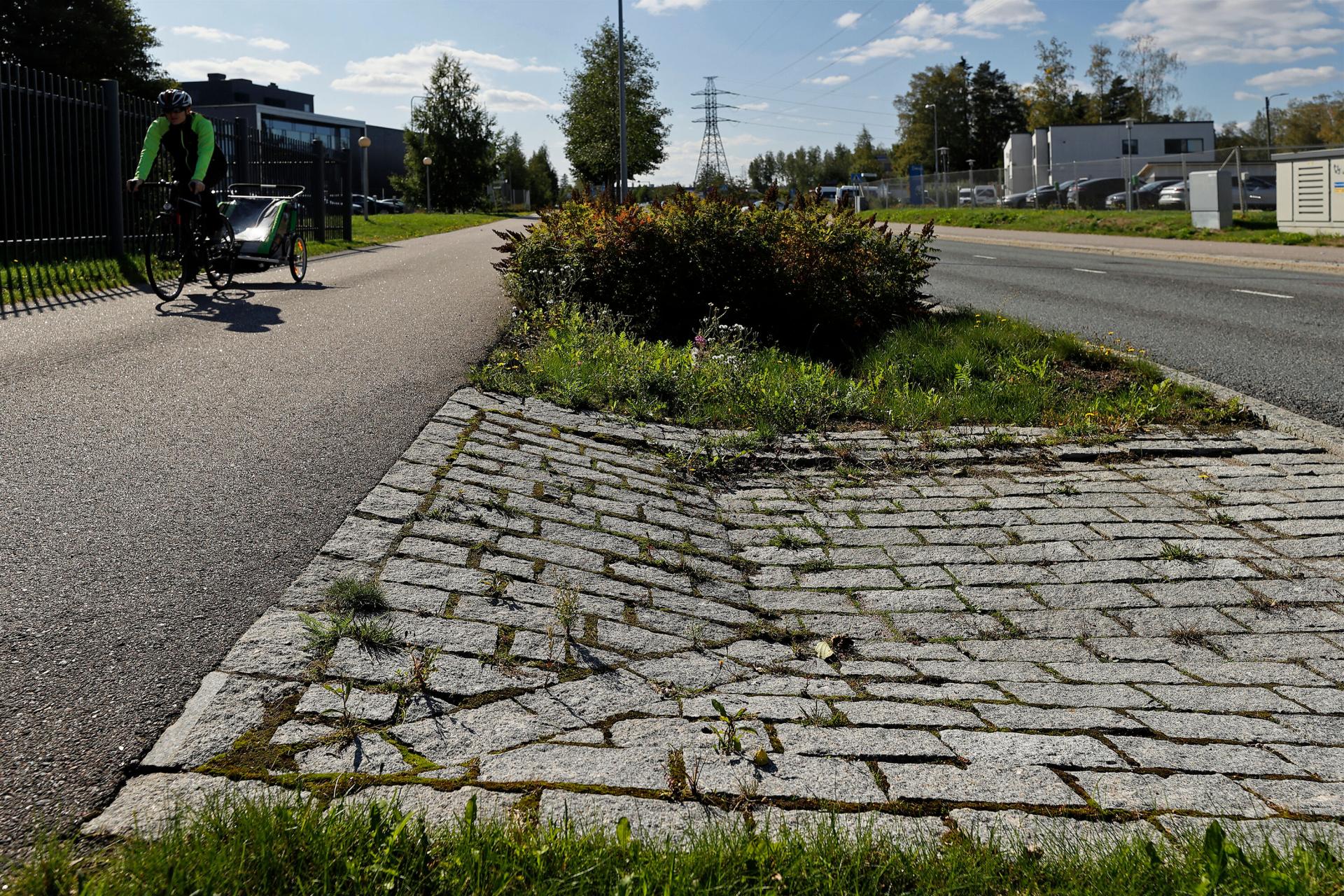
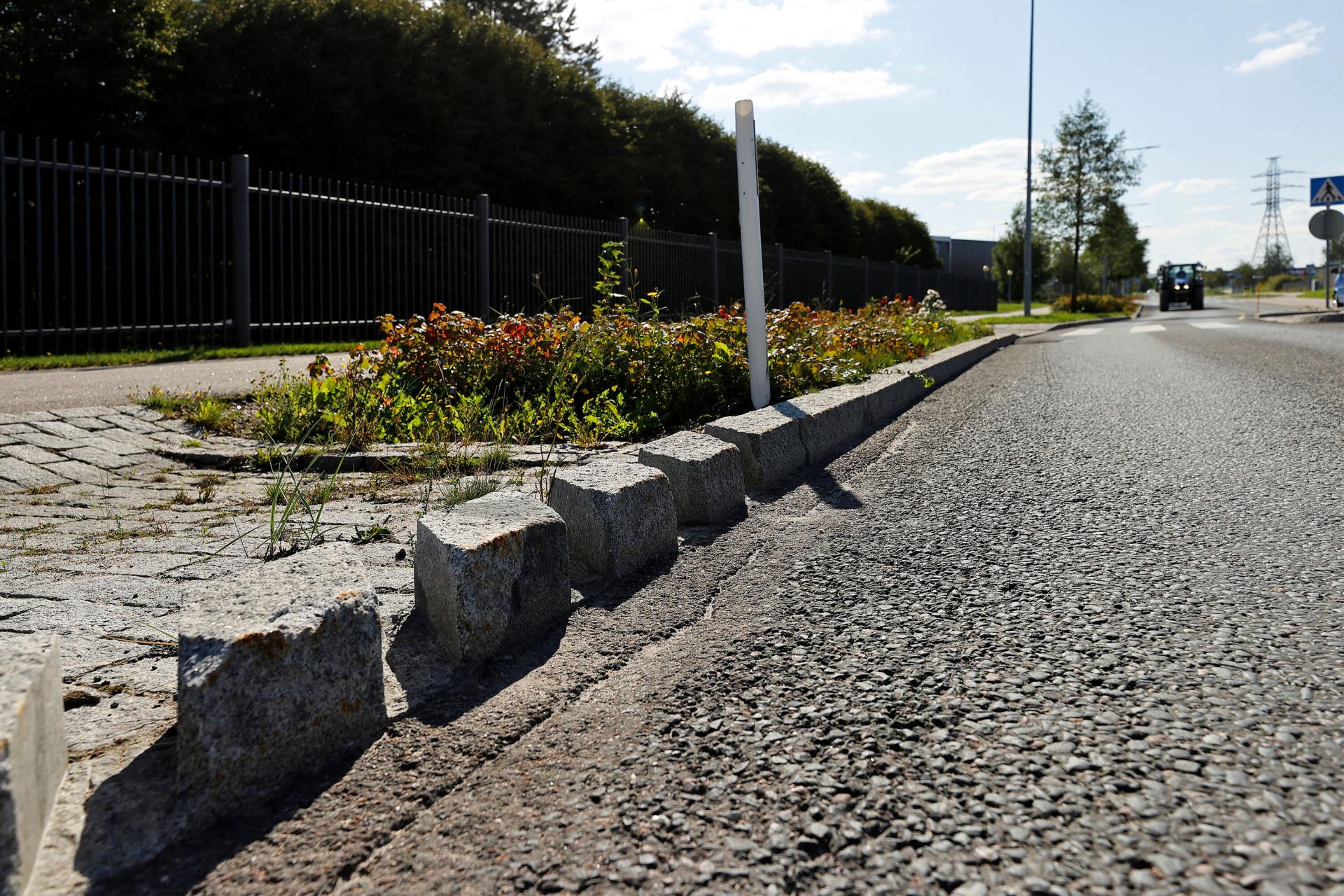
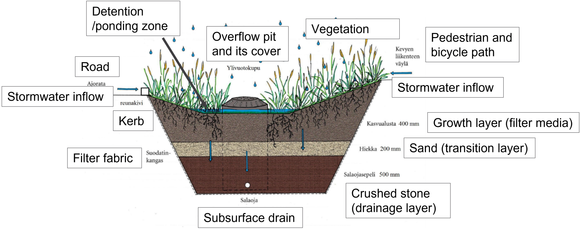
Selected stormwater management solution in Kauniainen
City of Kauniainen is the smallest of the HMA cities, only 6 km2 (Siitonen and Banafa 2016). Its cityscape is characterised by one-family houses and close proximity to nature. The population currently stands at about 10 200 (2021). (City of Kauniainen n.d.). In 2036, there are estimated to be circa 11900 inhabitants (HRI 2021), and thus the population growth is expected to be modest in the next 15 years.
Almost one-fourth (24%) of Kauniainen’s surface area is built-up (or otherwise impermeable) (Figure 36). The city includes 3 out of 4 land use types defined in the RAINMAN project as it does not have any historical areas.

The city does not have a dedicated program or a specific working group for stormwater management. The only public document found regarding stormwater management in the city was an instruction sheet about conveying of stormwaters (Kauniaisten kaupunki, n.d.a). However, an investigation of the city’s catchment basin has been carried out that can be utilised in developing a stormwater strategy or examining stormwater flood risks (Siitonen and Banafa 2016).
In Kauniainen, open ditches and depressions are mainly favoured in treating (evaporating and detaining) stormwaters. This is because the city is hilly and rocky with narrow street networks. Also, the small city is surrounded everywhere by the City of Espoo and the stormwaters are discharged into Espoo. Hence, it is attempted to reduce the point load to Espoo by retaining and detaining stormwaters as much as possible. (informants).
Skvatterbäck creek
Location: Thurmaninpuisto park
Management / system type: conveying, detaining
Land use type: green or natural area
Catchment basin: Finnoonoja
Built: creek was modified in 2009, park finished in 2010
Description:
Kauniainen's Thurmaninpuisto park is the biggest built park area in the city and an important recreational area for the residents. Through the park flows the Skvatterbäck creek, that collects the stormwater from the city centre. The original creek was modified in 2009 in connection to the development of the park to make it an attractive and functioning continuation of the city centre. The modification of the creek made it more natural and added detention areas for water. Therefore, the Skvatterbäck creek has conveying and detaining features (see Fig. 37). (Hentinen 2009, Kauniaisten kaupunki n.d.b, Silvennoinen, n.d.).
The vegetation in the park is diverse and contains both naturally occurring and purposefully planted vegetation. The plants have been carefully selected so that they bloom in different times of year. In addition to open grassy areas, there are different types of bush and perennial plants as well as decorative trees. In the middle of the park there has been planted a small fruit garden with apple, plum and cherry trees. In the beginning of the summer the little island in the middle of the creek is full of blooming Siberian irises. Irises withstand well changing conditions (see Fig. 38). (Hentinen 2009, Kauniaisten kaupunki n.d.b, Silvennoinen, n.d.; informants)
The plants on the edges of the creek were selected so that they need less maintenance (Hentinen 2009). Maintenance is also about keeping the creek open so that water can flow freely. Monitoring has never been carried out in terms of stormwater quality. (informants).
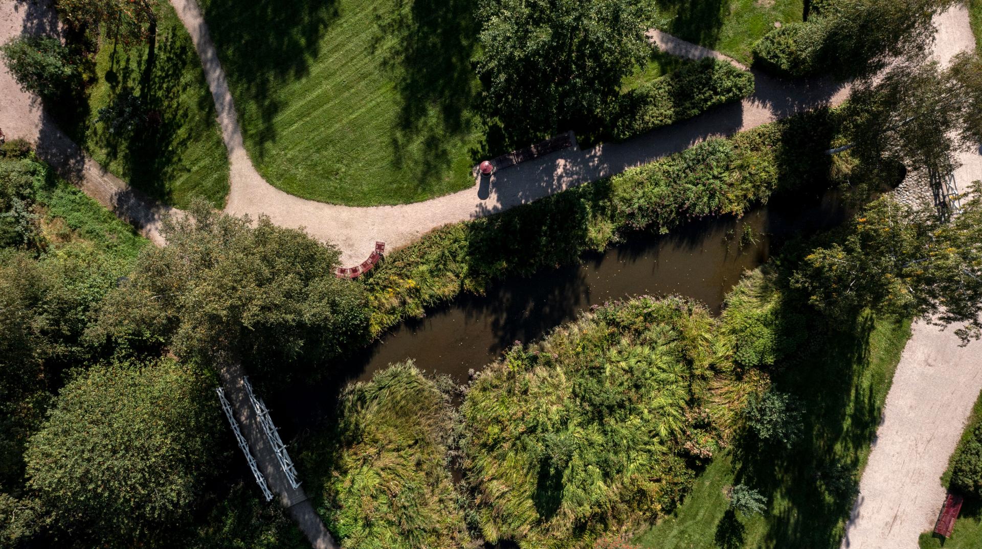
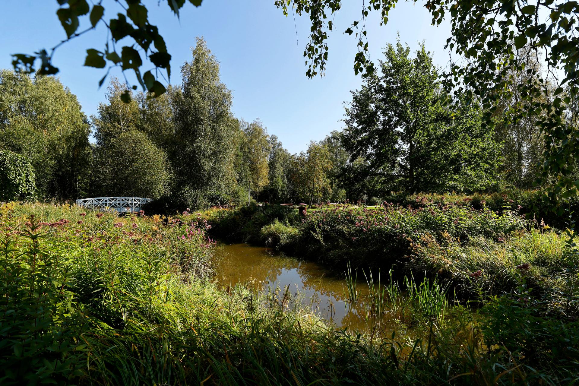
Discussion
This Chapter discusses the interview findings in light of the research questions in Section 2.1. and the reviewed literature. Also, perspectives from Chapters 6-9 are brought to the discussion especially in terms of types of solutions, monitoring & maintenance as well as governance.
As presented in Chapter 3, the definitions of “green” and “nature-based” solutions for stormwater management have many similarities. Also terms “ecological” and “natural” have been used in the same context. Interviews of city informants were used as an opportunity to clarify which terms are currently utilised in the field.
When asked about the definition, or the way city representatives speak about nature-based solutions in the stormwater management context, three out of four cities made a distinction between a nature-based (in Finnish “luontopohjainen”) and natural (in Finnish “luonnonmukainen”) solution. Informant from Helsinki expressed favouring the term “natural” because the nature-based solutions can be understood to be strongly constructed but imitating nature, i.e. “built nature”. The most effective stormwater management was argued to usually be existing nature that is not touched. However, that was considered rare and challenging thing to do in built environments. Vantaa’s informant told that her colleague suggested one should talk about “sustainable” stormwater management because none of the solutions may be fully natural.
Informant from Espoo likened the two terms similar; however while nature-based can mean being inspired by nature, it can also mean implementation that is artificial (Helsinki representative called it using partly technical solutions). Natural stormwater management was described to be about utilising the existing environment and implementing the solutions so that they support nature’s structures and understanding that it has also other values beyond stormwater management such as increasing biodiversity. The management solution is not only a technical implementation but also about looking at the benefits of nature more holistically.
These responses reflect the fact the use of the term “natural stormwater management” has been in use longer than that of nature-based solutions, and it has become established in the vocabulary, among other things, in the Finnish stormwater related legislation, guiding documents and city-level programs. The idea of natural stormwater management is included in related principles and strategies and has largely become business-as-usual thinking.
Having said that, the definition of nature-based solutions appears to be more clearly defined especially in terms of responding to several societal challenges, resulting in multiple co-benefits as well as being more efficient and cost-effective than traditional approaches (see Section 3.3.). Therefore, it seems that natural stormwater management has still some way to go to be strictly considered as nature-based solutions. For the purposes of this study, however, green or natural stormwater management is considered to be included in nature-based solutions for stormwater management.
Stormwater management solutions favoured by the cities
Reflecting on the previous question, the stormwater management solutions the HMA cities implement are often hybrid solutions, that is, including both green and grey infrastructure. This is likely due to dense building in cities. The lack of space, that nature-based solutions often require, leads at least partly to underground structures, such as cassettes and pipes, with aboveground infiltration and detention structures. Lack of space was brought up by informants from all HMA cities; it was argued as a limiting factor for NBS also by EEA (2021) and Oral et al. (2020).
In Helsinki, detention and sedimentation basins are reported as the most common structures. However, there are also other solutions that have been implemented (or in development, such as those in the Kuninkaantammi ecological district). While Helsinki is the only city exhibiting the historic built-up land use category, no nature-based solutions were found to have been implemented in the historic city centre and the stormwater goes straight to the combined sewerage. This is because Helsinki city centre includes a lot of underground infrastructure that prevents basic types of stormwater infiltration structures. Temporary solutions, such as greenery in parking spaces, could be implemented but not because of stormwater management but to enhance the area’s attractiveness.
In Vantaa, it was emphasised by one of the informants, that the priority order dictates that stormwater is treated and utilised at the place of origin, and new town plans also require that (the same applies in Helsinki). Therefore, detention solutions in yards have become common though solutions vary quite a lot. In fact, according to another city informant, there have been built (or designed) about 50 stormwater management structures in the last 20 years, mainly aboveground and natural structures such as detention basins, wetlands and biofiltration areas.
In Espoo, wetlands and stormwater basins are frequently built and utilised, and thus clearly favoured. Many different types of stormwater management solutions have been utilised depending on the available space, limitations of the landscape and the objectives of the management. The choice of solution is largely based on the management need, that is, whether quantity or quality management is implemented, both or if groundwater is to be considered. Also very important criteria are how these solutions are maintained and what the recreational, attractiveness and nature values are. Wetlands are intended to look like natural wetlands, but they are constructed (or “artificially implemented”) and need to include maintenance routes.
In Kauniainen, open ditches and depressions are mainly favoured in treating (evaporating and detaining) stormwaters. This is because the city is hilly and rocky with narrow street networks. Also, the small city is surrounded everywhere by the City of Espoo and the stormwaters are discharged into Espoo. Hence, it is attempted to reduce the point load to Espoo by retaining and detaining stormwaters as much as possible.
These findings reflect what was presented in the literature on the frequent combination of green and grey solutions. As Seddon et al. (2021) put forth, there is an opportunity to discover synergies among different solutions instead of considering nature-based solutions as an alternative to engineered solutions. When comparing to the study of Ruangpan et al. (2019) on the most common NBS measures in urban areas, the Helsinki Metropolitan Area solutions seem to include more wetlands and detention basins. It might be either that structures like permeable pavements, green roofs and trees are more frequently utilised in private areas (such as in Helsinki where the Green Factor is used in private plots); or the HMA still has relatively more space and permeable areas compared to other urban areas in the world. As Ruangpan et al. (2019) indicates, combining nature-based measures can lead to greater runoff volume and peak flow reduction.
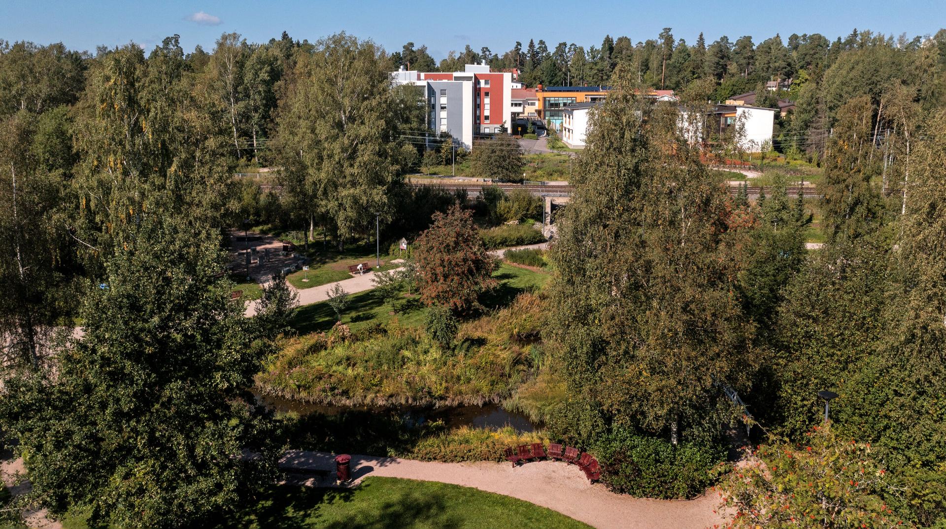
Co-benefits of stormwater management solutions
In common areas in Helsinki, adding green is not done only on the basis of stormwater detention but also to increase the area’s attractiveness (e.g. for instance in parks the water elements are part of the park’s or area’s structure). However, it is also recognised that, in the event of increased frequency of heavy rains, the only way to increase detention, and decrease the water flow to sewer system pipes, is to apply green solutions.
In Vantaa, the design of nature-based solutions is considered in a multifaceted way; landscape architects and water services management engineers jointly plan these solutions to manage the stormwater quantity and quality, related vegetation and through that biodiversity opportunities and aesthetics.
In Kauniainen, it is admitted that not all natural stormwater management benefits have necessarily been recognised, and that there is no working group to determine these values. However, they are increasingly recognised along with the increasing general awareness. The benefits have become from the architectural design to land use and planning.
In Espoo, biodiversity is said to be well considered in the design of stormwater management solutions, even though it would be good to think what it actually means. For instance, when a stormwater wetland is built, generally a flood plain meadow mix is added (or other similar beach meadow vegetation mix) and just left to develop. The maintenance is maintaining the open water surface, ensuring that the in- and outlets stay open and removing the sediment gathered on the bottom. In the future, it would be good to go further than this, for instance, to think about if there are trees around the wetland, and what types of edges the banks are; as well as what type of maintenance it is, what is removed and what is left, and what types of species it might attract. And, if there are already some species, it is useful to consider how it is connected to other same types of sites or solutions. That is, while the quantity and quality of stormwater management is the priority of these wetlands, one has to think about how the biodiversity is actually realised. That has to be considered both in the design and maintenance phase. There is also a need for monitoring and knowledge on user experiences, argued one of the Espoo informants.
As was presented in Section 3.3., nature-based solutions provide a number of other benefits in addition to managing the stormwater quantity and quality. Helsinki’s Helene Schjerfbeck’s park and Vantaa’s Koisotie road snow reception area serve as good examples of sites where recreational, landscape and biodiversity enhancing benefits are combined with management of stormwater quantity and quality. It is noteworthy, however, that the benefits mentioned by the cities' staff were rather limited (e.g. biodiversity, attractiveness, recreation) compared to the larger set of benefits presented in different studies. This suggests that there may be difficulties in assessing such benefits, or that the cities' staff are not aware of them.
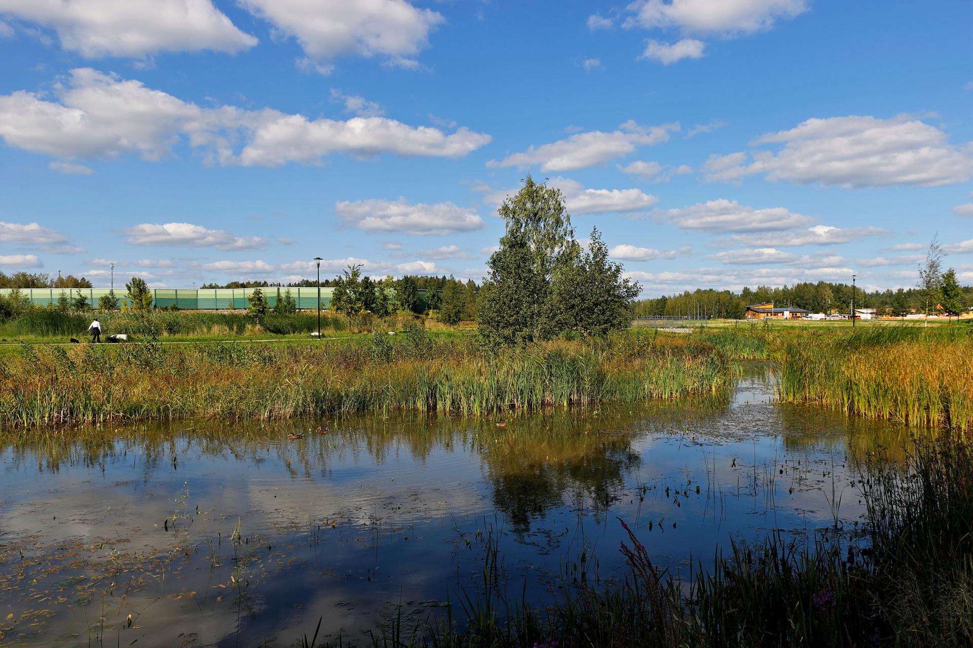
Planned stormwater management solutions
The informants also spoke about what is planned at the moment in terms of stormwater management in developing city areas. In Helsinki, Hermanninranta beach was mentioned as an interesting example where the construction is intended to conserve nature. The planning and town plans are now in development. The common areas will include a lot of green infrastructure and stormwater management solutions.
In Vantaa, Aviapolis (a major area in the center of Vantaa with a population of about 20,000, and home to the international Helsinki-Vantaa Airport) is intended to exhibit sustainable city development in which former employment areas are transformed into residential areas without destroying existing nature. Nature-based solutions are very important when the area’s purpose of use is changed. For example, large stormwater pools are planned for the area near the centre; also the new town plans of the area define the inclusion of biofiltration areas, a lot of vegetation and such. Also, the lack of space was considered a central issue when the city’s growth is based on densification. Only the areas that were reserved for building in forests and on fields in the current master plan can include “new openings”. Nevertheless, when the city is renewing with dismantling renovation for instance in the Veromies area in Aviapolis (that has massive logistics storage halls and asphalted parking areas), nature can and will be brought in with nature-based solutions from where it has earlier been fully removed. Kivistö is another developing district where several nature-based solutions are planned to be applied, and roof spaces are to be effectively taken into use (See Chapter 8.).
In Espoo, spaces for stormwater management solutions are attempted to be found from green areas or such in the planning phase. Nevertheless, problematic are especially those old areas where there is no space for new solutions, and there is a need to seek underground solutions. It is rarer that impermeable surfaces have been removed. In this instance, it was mentioned that underground solutions, such as the Otsolahti biofiltration site connected to the main stormwater line, have been tested and noticed that such underground structures are very challenging to maintain, and to monitor how well they work. It is considered safer to implement aboveground structures even though the area has a lot of impervious surface. Also when going underground, one loses the other benefits, such as recreational values and increasing biodiversity.
In south-east Kauniainen, at Bensowinkuja street, the city has prepared for increased runoff along with the anticipated building of the nearby area by reserving a space in which a bigger detention basin could be built to avoid flooding. The site at the moment has a natural stormwater management solution, a ditch with erosion mats and planted perennial plants withstanding moisture.
The reviewed literature mentions removing impermeable surfaces especially in the larger-scale content of implementing NBS. In this study, this option concerns also smaller-scale solutions. New areas and old areas with change of purpose offer opportunities for the nature-based solutions to be built. Also, while there is a limited space for nature-based solutions on the ground level, roof surfaces can offer more opportunities to implement NBS.
Monitoring of function and maintenance
Helsinki
According to a Helsinki informant, the function of stormwater management sites has been often monitored only during the duration of the externally funded projects – or if it has happened after the project, it has been carried out irregularly. Monitoring is considered rather costly and demanding to realise and, funds have not necessarily been budgeted to it. Nevertheless, as mentioned in Section 6.2., the City of Helsinki is currently examining the water quality improvement performance of some of its nature-based stormwater management sites.
Also, the selected sites in Helsinki – Kuninkaantammi ecological district’s and Maunulanpuisto park’s solutions – the performance were found to be monitored at least to a certain extent stormwater quality wise (while Kuninkaantammi is a newer site and there is not much monitoring data available, Maunulanpuisto park biofiltration area has been monitored also after the project, within which the solution was realised, has ended). While the city does not have register or maintenance card file of stormwater management sites, it is currently in the process of investigating its nature-based stormwater management structures. This was motivated by the requirement to consider stormwater management structures in the city plan; also putting the master plan in practice has made the issue timely, and the requirement to use the Green Factor leads to the implementation of natural stormwater management solutions in plots. Moreover, this process has been boosted by the HUTI project (see Section 4.1.).
Vantaa
Vantaa has developed a maintenance register or card file for stormwater management sites that is intended to support monitoring of the city’s stormwater management sites. Maintenance cards include a timetable and task list of checks; also timing of long-term maintenance is defined. The city has also estimated the costs associated with stormwater management sites’ maintenance in 2021-2026. Both informants expressed that there is usually lack of resources for building, and especially maintenance, of stormwater management systems. The maintenance register however can partly tackle this issue.
Related to the monitoring of co-benefits, such as nature’s biodiversity, one of the informants considered that monitoring of vegetation development would be interesting, though thought that it is not probably done, and no resources have been reserved for that.
It was brought up that the pilot sites have rarely long-term monitoring. With regard to the city’s selected solution sites, also considered pilots, (Koisotie road's snow reception area and Meiramitie road bioswale), both are to be visually monitored yearly. However, there is little or sporadic monitoring data available. The Meiramitie road site was deemed having issues e.g. with levelling and stormwater flowing to an unwanted direction (see Section 8.2., Lehikoinen 2015), and these can act as learnings for similar biofiltration sites in the future.
Espoo
Also in Espoo, there are maintenance cards for stormwater management sites that include the objectives for maintenance, and tasks to be performed during checks. However, it seems that they have not yet actively been updated since they were developed in 2019 (see Chapter 7).
On of the informants considered the exclusion of monitoring a large shortcoming in implementing stormwater management structures, especially the nature-based ones. In other words, many stormwater management sites are lacking the monitoring information, and only a few have included the follow-up after they have been built. At the moment, the maintenance team goes to check the sites regularly just to remove unwanted or excessive vegetation. There would not only be a need for data on how the wetland works (requiring information on flow changes as well as taking water samples and laboratory analysis) but also for how often it needs maintenance. Also of interest would be to find out whether different types of structures have differing maintenance needs, or whether the ‘nature benefit’ is maximised and if that significantly increases the maintenance need. This information would help determine whether wetlands (or other stormwater management structures) should be realised in locations with existing nature, such as park land or green areas, or whether they should be prioritised in areas where the impermeable surfaces need to be removed.
Moreover, monitoring was considered a funding issue rather than a staff number or know-how issue. The process of developing a nature-based stormwater management solution was called for to include the maintenance and other essential personnel at an early stage. Otherwise, at later stages of the process one might too late notice that the solution is difficult to maintain.
The informant also proposed a common project to be implemented in the Helsinki Metropolitan Area in which different types of, as well as older and newer stormwater management structures would be monitored and collected user experiences. This could partly overcome the funding issue for monitoring and help generate information on the benefits of stormwater management structures and their maintenance.
With regard to the selected sites in Espoo, the performance of the solutions has been determined only visually in Huhuilijanpuisto park wetland, whereas the Merituulentie road bioswales have been monitored at least once for stormwater quantity and quality. As presented in Section 7.1., in Huhuilijanpuisto park the maintenance checks detected a need for repair measures, and the informant shared a learning that stormwater management sites do not often form a functioning whole instantly.
Kauniainen
In Kauniainen, the maintenance need of the current few sites is reported to be low, or not needed, as the water amounts have been low and there are generally no structures that would require maintenance (such as wetlands or detention basins with no infiltration ability). In fact, the maintenance is mainly keeping the conveying stormwater structures open so that the water can flow forward. In addition, the sites have been selected that type of vegetation that does not hinder the functioning of the site. When it comes to the quality monitoring of stormwaters (e.g. for hazardous substances or heavy metals etc.), that has never been done in the city. The examination of the performance is largely that the flood risks are minimised. One informant had suggested such measurements earlier, but the equipment would have been too costly for the city to fund it.
To summarise, monitoring of nature-based stormwater management sites is generally considered insufficient or lacking. This is the case especially in terms of quality management that requires taking water samples and laboratory analysis. The interviews confirm that the focus has mostly been on managing stormwater quantity but recently also quality has become of interest. Visual checks and regular maintenance are said to be performed in three out of four cities, but the quality monitoring is rather rare (or limited to projects or student thesis works) due to a lack of funding. However, maintenance card file in Vantaa and Espoo help keep track of maintenance needs and partly help allocate limited funds. Other benefits like biodiversity are not clearly defined or monitored. Hence, in many cases, it is not possible to determine how successful these nature-based structures are as there is often no monitoring data available (of the stormwater quality or other benefits such as biodiversity maintenance). While not specifically investigated in the interviews, impact evaluation was not brought up in any interview in connection to the monitoring of solutions.
As emphasised by the European Commission (2021a), monitoring and impact evaluation of nature-based solutions is vital to measure the success of individual nature-based projects, and to inform further actions as well as to support evidence-based land use planning and policy-making. Moreover, those are essential to fully understand the benefits and trade-offs of such solutions (European Commission 2021a).
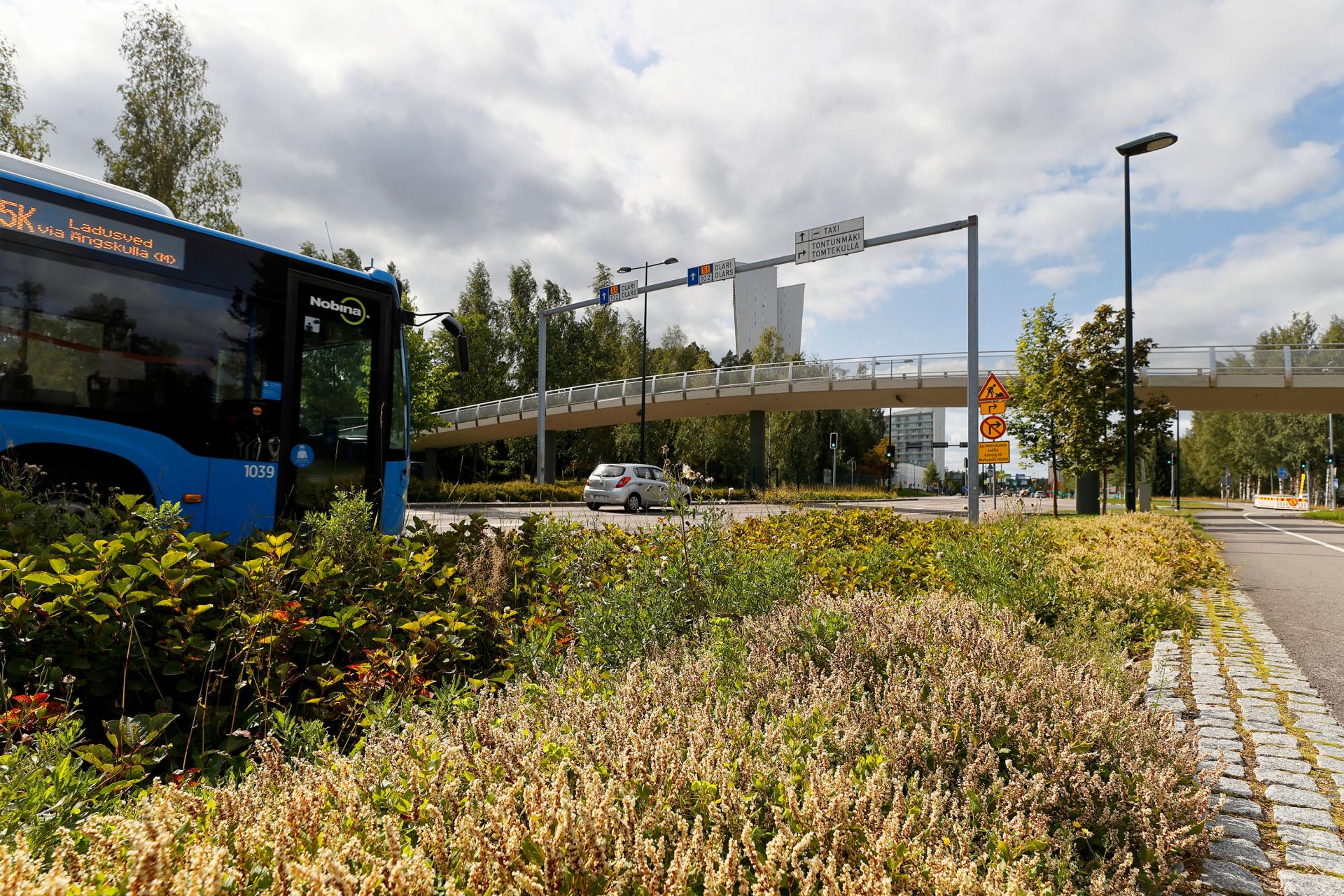
Governance structures and practices
Helsinki
As mentioned in Chapter 6, City of Helsinki has a stormwater group consisting of representatives of different services of the Urban Environment Division. According to one informant, the group is performing its task alongside with other work, is decentralised to different services in the Urban Environment Division, and does not have authority e.g. on allocating resources. In addition, while technical planning of stormwater management is involved with land use planning – of which natural/ nature-based solutions are part – nature-based solutions or integrated water management do not have its own expert in the planning process. Hence, it was argued that the city would benefit from a dedicated stormwater coordinator or responsible person. In any case, no group was seen to be able to take responsibility of the whole city-level stormwater management.
It should be noted that the stormwater group has recently gotten a new chair, and there have been discussions in the group that climate change adaptation acts as an umbrella issue to stormwater management issues. The ownership of stormwater issues was to be discussed as of summer 2021.
An informant also put forth that the dialogue should be very tight or seamless when the methods, and management of living organisms like trees and other vegetation as well as soil, are so different from traditional grey structures and “basic pipe job”. It requires different types of action, know-how and cooperation practices. The city’s Storm Water Management Program is an attempt to the direction of bringing all important actors around the same table (or program), such as the experts or their representatives dealing with the planning and management of stormwaters as well as maintenance. Unlike pipes, the natural or nature-based structures need continuous upkeep that takes time, are more diverse and involve multi-actor work. No one yet fully knows what works where and how – and it is not as simple as it may look like, the informant stated.
Vantaa
In Vantaa, city’s stormwater working group has convened since the establishment of the stormwater management program (2009). That is the essential governance structure with all the relevant internal people and includes also external stakeholders. The stormwater management program from 2009 is still considered to be relevant as it has the main principles and was followed by the stormwater management operation model (2014). Also, there is the established practice built in the town planning to examine how the stormwater management system is going to work in a specific area. Streets and parks in public areas include stormwater detention areas. In addition, the “Green Efficiency” method is defined in all town planning, and can contribute e.g. to adding vegetated (green) roofs in living quarters.
One study investigating the function of the Meiramitie road biofiltration site emphasised as the most important learning changing of meeting practices to make sure a continuing dialogue with all affected parties throughout the process of designing, building, monitoring and maintenance. It was also considered essential to document both successes and challenges to be able to learn from them. (Lehikoinen 2015).
Espoo
Stormwater management solutions are generally implemented as part of the park design or town planning processes, so the locations of stormwater management structures are defined in the town or park plans. These processes actively involve the environmental protection service area, and include many types of experts from urban engineering, maintenance staff, recreation people and engineers to discuss how to place playgrounds and how to take stormwater utilisation into account in them. The cooperation was considered to work well, and everyone is really interested in advancing stormwater know-how.
The city has its own stormwater working group, which convenes several times a year. It discusses stormwater management solutions and development issues in a diverse way (such as what types of structures are safe and enable passing of aquatic animals). The group includes broadly different city departments and tries to reconcile various viewpoints in the best way, and then instruct the service providers about the best solutions.
There is also the climate change adaptation working group that discusses these matters to some extent. Moreover, a so-called power team has been formed, consisting of five persons (two from urban engineering, two from building inspection and one person from urban environment sector) that solves problems related to stormwater damages. This team is assisted by law personnel. The team has made an instruction on how to deal with situations in which, for instance, an open ditch starts to flood, and it causes damages to the buildings. Stormwater related issues are often so diverse that one actor is not enough. They have noticed in the city that all three departments need a common discussion so that they know how to act.
Also, one informant calls for courage to test and try different types of solutions and finding an optimum for every site, instead of a “assembly-line implementation”, even if funds are tight. The city staff is open to hear about new ideas and innovations, and they add inspiration to these projects.
Kauniainen
As a small organisation, Kauniainen does not have a dedicated stormwater management program or similar. The small size was regarded a strength in a sense that a certain issue can be activated, and relevant people can be gotten on board, rather quickly. Also, the information flows quicker to the right people compared to a bigger organisation. There is the community office’s project working group that can discuss these matters. However, the smallness can also be a challenge when there are too many other issues to work on.
In the literature review, governance, organisational interaction and collaboration and planning practices were highlighted as some of the major barriers to transitioning to a more sustainable stormwater management (Bohman et al. 2020, Rehunen et al. 2021). Based on the findings in this report, three out of four HMA cities have a stormwater management program as well as a stormwater working group. The working groups appear to be well aware of the nature-based solutions and they play an important role in advancing such solutions.
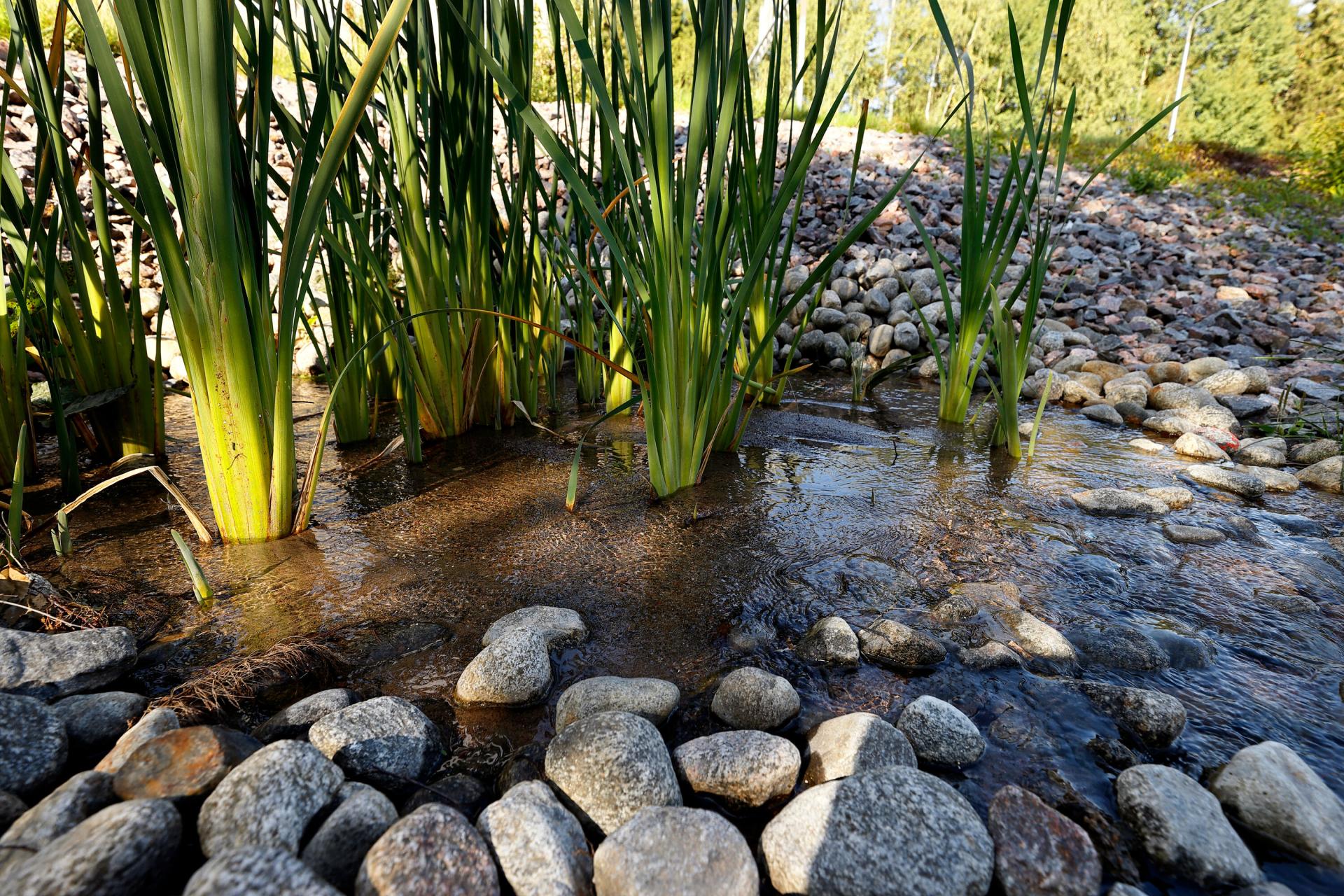
Hindering factors for nature-based stormwater management
While previous sections have addressed many of the barriers or factors hindering adoption of NBS to stormwater management, other aspects came up, too. Those were general awareness and attitude of the community.
In Vantaa, no objection was known for nature-based or natural solutions to stormwater management. In Kauniainen, community feedback that they have received is along the lines “why is the city maintaining a mosquito pond”. It was expressed that certain groups of people recognise the benefits and values of nature-based solutions, and that single staff members’, or politicians’, training, and awareness in general may facilitate nature-based solutions.
In Espoo, however, inhabitants have had concerns for instance about the stormwater detention pools, e.g. on child safety, mosquitoes or whether the standing water can start to smell. Such issues were considered to be able to be solved already in the design phase if the aim of the stormwater management structures is carefully considered, e.g. how solid matter and nutrients are removed, and how it is ensured that this structure will develop into a functioning ecosystem. As an example of community opposition, a planned stormwater pool was not built in Ruomelankorpi green area, Olari, due to inhabitants next to the area considering the change of landscape being too drastic. Therefore, instead of building the pool, the city modified an old pool upstream and built a new flood pipe, and as a result, these detain stormwater adequately.
As was showcased in Helsinki’s Maunulanpuisto park and Vantaa’s Meiramitie road, informing inhabitants of the stormwater management structures is important and can increase the acceptance of such systems.
As mentioned in Section 3.3, participation and the inclusion of stakeholders’ viewpoints from an early stage of the design of nature-based solutions are considered critical in ensuring public acceptance (EEA 2021).
Conclusions
This report set out to identify good practices and solutions to green or nature-based stormwater management in urban areas, focusing on the Helsinki Metropolitan Area and targeted at the four land use types defined in the RAINMAN project. By doing so, it has provided a snapshot of the definitions, types of solutions, co-benefits, monitoring and maintenance, as well as governance structures and strategies for nature-based solutions for stormwater management. Therefore, it examines the prerequisites of cities to implement such solutions. It showcases eight nature-based stormwater management solution sites in the HMA with photos and detailed information. These are complemented by rich interview data of the cities' staff members and literature review. Much of the data has been available previously only in Finnish and this report brings the information to the attention of the international audience .
The solutions and supporting information presented in this report are intended to facilitate the adoption of nature-based solutions in urban water management, and more specifically in stormwater management. Thus, it aims to enhance the capacity of cities to prepare for and adapt to the impacts of climate change in line with the RAINMAN project objective. The project has offered a platform to share experiences and best practices among project partners, supporting mutual learning and exchange of information. The results of this work, however, can be utilised in other areas facing similar urban development and change in climate, and may benefit the work of city professionals working in urban water management.
Based on the findings presented in this report, following points are determined as facilitating factors or drivers for such solutions:
- There are national-level steering measures and legislation in place that support integrated and nature-based stormwater management, including requiring municipalities to develop integrated stormwater management in areas where a local detailed plan is in force.
- City-level stormwater management programs dictate that the management, treatment and conveying of stormwater follows the priority order set by the national level stormwater legislation. They also recognise the values beyond stormwater quantity and quality management.
- There is a dedicated body, like a stormwater management working group including all relevant actors and ensuring seamless communication and cooperation on stormwater management issues.
- Green Factor and Green Efficiency tools, such as those used in Helsinki and Vantaa, support the aims to increase green areas and nature-based solutions in the city.
- The process of developing a nature-based stormwater management solution considers monitoring and maintenance (e.g. by directing funds and including the maintenance staff and other essential personnel at an early stage).
- Stormwater management data is organised into a city-level maintenance card file (such as in Vantaa and Espoo) that can help keep track of maintenance needs and offer ways to develop old operation models.
- Monitoring and impact evaluation of nature-based solutions are essential to be able to determine their success, as well to support evidence-based land use planning and policy-making. They also support increasing the understanding of the benefits and trade-offs of nature-based solutions.
- Documenting and sharing both successes and failures in implementing nature-based solutions can serve as learning for others, increase the understanding of the various solutions’ function, and strengthen cooperation among various actors.
- Increasing amount of impermeable surface and densification aims lead to a lack of space to implement nature-based solutions. However, when changing the purpose of areas, for instance, when industrial areas are converted to residential areas, there is a chance to remove impermeable surfaces and replace them with green areas and nature-based solutions. Also roof spaces can offer opportunities to introduce nature-based solutions.
- Hindering factors like community opposition can already be solved in the design phase when the local context and aim of the stormwater management structures are carefully considered.
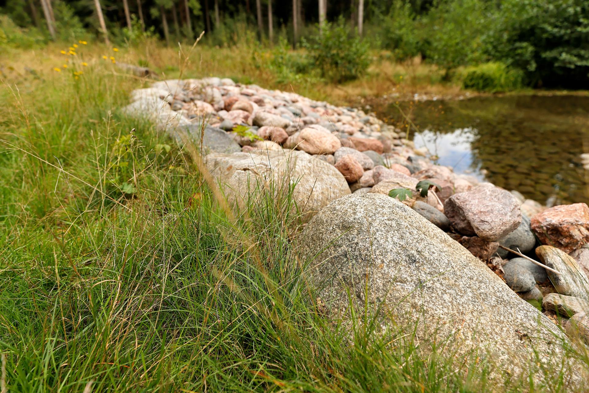
Appendix
Developing (or rural) areas | Densely built-up areas | Historic built-up areas | |
Challenges | • Lack of data for adequate design of systems (e.g. expected increase in rainfall and runoff) • Green areas/ vegetation are not accounted for during the development of urban areas • Conflicting interests | • Amount of impervious cover is high • Lack of space for nature-based solutions • Inadequate sewer systems | • Amount of impervious cover is high • Area development regulations • High costs of retrofitting existing sewer systems • Inadequate sewer systems • Combined sewer • Lack of developed flood routes for increased rainfall and extreme events |
Solutions | • Nature-based solutions designed hand in hand with other planning • Using the green factor tool • Construction of drainage channels in nearest suburbs • Taking into account urban flooding in the planning phase • Development of standards regarding dimensioning of systems | • Adding green roofs in buildings when applicable • Guiding water to areas where is does the least harm, away from critical infrastructure • Retention tanks construction/ system flow control and redirecting with valves • Mandates for stormwater retention in individual plots • Modernisation of water disposal systems taking into account updated climate parameters • Surface permeability ratio decrease | • Parking lots turned to micro parks with plants • Development of adaptive storm water management • Use streets as water routes in the case of extreme rain events (Copenhagen example) • New solutions that can work alongside existing stormwater infrastructure |