Nature-based solutions for stormwater management in the Helsinki Metropolitan Area, Finland – Prerequisites and good practices
Information
Helsinki Region Environmental Services Authority
30.12.2021
Nature-based solutions for stormwater management in the Helsinki Metropolitan Area, Finland – Prerequisites and good practices
Helsinki Region Environmental Services Authority
P.O. BOX 100
00066 HSY
Tel +358 9 1561 2110
Faksi 09 1561 2011
www.hsy.fi
Author: Niina Kautto
Further information:
Maaria Parry, maaria.parry@hsy.fi
Cover photo: HSY/ Mikko Käkelä
Selected stormwater management solutions in Vantaa
City of Vantaa is Finland’s 4th largest city with more than 237 000 inhabitants (2020); it grew the most of all Finnish cities that year. It has an international airport and consists of seven major regions (City of Vantaa n.d). In 2045, Vantaa’s population is estimated to grow to 322 000-348 000, depending on the scenario (Mänty and Riihelä 2021).
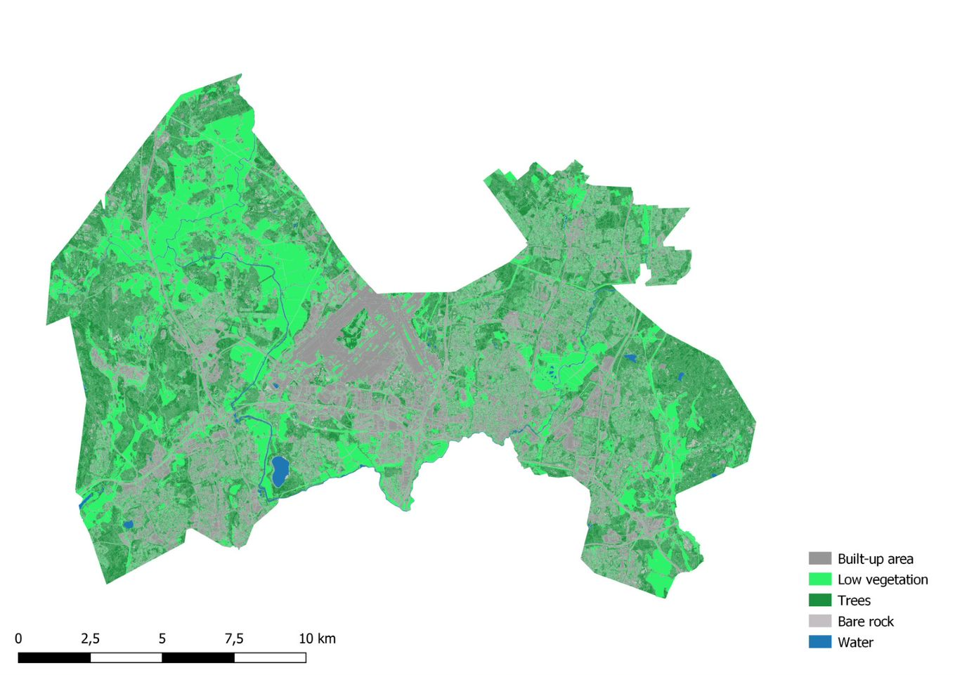
City of Vantaa has almost one-third (29%) of its surface area covered by impermeable surface (Figure 28). It includes 3 out of 4 land use types defined in the RAINMAN project as it does not have any historical areas.
Vantaa developed its stormwater management program in 2009; it was only the second of such a program in Finland at the time (Lehikoinen 2015, Vantaan kaupunki 2009). It was complemented by a stormwater management operational model document in 2014 (Vantaan kaupunki 2014a). A guide on stormwaters of the built environment and roof vegetation was published also in 2014 (Vantaan kaupunki 2014b).
The operational model was developed as a set of instructions to those who direct the construction in Vantaa. It guides the planning and building according to the principles defined in the 2009 stormwater management program. It applies to all new building as well as infill development in the city area. The operational model mainly concerns business, industrial and public buildings as well as blocks of flats of which plots have less permeable surfaces than single detached house plots, and thus are likely to have more issues with stormwater management. The operational model advices planners and builders on stormwater management methods, and planning principles; and showcases some of the stormwater management sites in the city. (Vantaan kaupunki 2014a).
The 2009 program includes the objectives and measures for integrated or holistic stormwater management, as well as the priority order of stormwater treatment. It outlined that stormwaters need to be primarily treated locally and the natural management is adopted as a common planning principle. (Vantaan kaupunki 2009, 2014a).
The main objectives of the stormwater management are (Vantaan kaupunki 2014a):
0. Reducing the amount of stormwater forming.
1. Managing the quality and quantity of stormwaters locally at the source.
2. Managing stormwater floods and preventing flood damages.
3. Protecting the quantity and quality of groundwater (clean and purified stormwater are infiltrated at the source).
4. Advancing waterway protection and urban nature’s biodiversity.
5. Preparing for the future changes in climate and land use resulting in growing amount of stormwater.
In addition to the structures managing the quantity of stormwaters, the City of Vantaa aspires to increasingly consider also quality management (informant). Both of the selected sites in this report include biofiltration area pilots, and are located on the east side of the international Helsinki-Vantaa airport.
Vantaa is a pioneer in planning a policy for vegetated roofs. If the policy was realised, it would one of the first of its kind in Finland. The city is still discussing whether the policy should be accepted – meaning that the city would be required to apply the policy in its own projects – or it should rather act as a recommendation. While it comes down to the costs, the policy is argued to lead to savings that would be largest in terms of stormwater management as the vegetated roofs absorb water and detain its flowing into the sewer. The vegetated roofs are considered to result in various other benefits such as reducing the heat island effect, maintaining biodiversity, improving air quality, increasing attractiveness of the urban environment, and allowing everyone – also movement impaired – to have green close to them. Moreover, they are protecting roof structures, and when insulating in winter and cooling in the summer, they help reduce energy use and muffle the sound. (Hovi-Horkan 2021).
Kivistö centre is a new developing district in Vantaa that envisions vegetated roofs everywhere in 2050, and that every roof is in use (Hovi-Horkan 2021, Vantaan kaupunki 2021a). Also various other nature-based solutions have been planned or already adopted in the area, such as biofiltration, permeable surfaces, urban farming and a stormwater basin (Rehunen et al. 2021). Water is intended to be a visual and functional element that is visible in urban spaces, it is used as part of an irrigation system for urban farming, and car parking is centralised in designated parking facilities. Therefore, there are more permeable surfaces for urban farming and nature-based stormwater management. The interim town plan of the Kivistö centre and its stormwater assessment have been used as a starting point for a multi-objective framework on nature-based planning solutions; it helps to recognise multiple benefits and objectives that enable them. (Vantaan kaupunki 2021a).
Murronpuisto Park in Kivistö has been planned as a stormwater park. A stormwater basin has been built in the park to detain Kivistö centre’s stormwaters. While this site was not selected as the one showcased in this report, it was brought to attention that it has not functioned as intended and the basin has retained too much water. This is because the pipe discharging the water from the basin has been at a too high level. (informant).
Similar to Helsinki, Vantaa has used a Green Factor-like tool in town planning since 2017, and from 2020 it is applied in every town plan. Vantaa calls it the “Green Efficiency” method that is essentially the same as Helsinki’s Green Factor tool. (Vantaan kaupunki 2020). Part of the green and blue infrastructure in Kivistö area has been planned by using the Green Efficiency tool. Stormwater management structures like a rain garden or a wetland raise the Green Factor or Green Efficiency. (Sanaksenaho 2015).
The city has developed a maintenance card file – inspired by that of Tampere – that includes information of the stormwater structures’ location, basic information and the timetable for maintenance. Every new stormwater management structure is developed a maintenance card. At the moment the information is in Excel-table form, but the idea is to publish it in the city’s own database and /or to be included to the HUTI database (first data like surface area, type, location etc.; qualitative and monitoring information would be added later), and more actively utilise it in the monitoring also. Maintenance costs have also been estimated for the next 5 years. All around city’s 50 stormwater management structures in public areas are intended to be checked yearly in September or October, and in this check next year’s maintenance and repair sites are proposed. Long-term check is to be carried out to about 4-8 structures per year. Maintenance measures in each site are to be reported in the electronic maintenance book that is kept up-to-date. (Auvinen 2021, Vantaan kaupunki 2018, 2019, 2021b; informant).
Koisotie road snow reception area, biofiltration area and wetland
Location: Tikkurila central park, Koivuhaka district
Management / system type: conveying, detention & infiltration
Land use type: densely built-up / green or natural area
Built: Planning in 2011, built in 2013 (Vantaan kaupunki 2021b)
Surface area: 1000 m2, water surface area 1630 m2 (Vantaan kaupunki 2018, 2021b)
Catchment basin: Kylmäoja stream (Vantaan kaupunki 2021b)
Drainage area: 19 km2 (Pihlajamaa 2010)
Description:
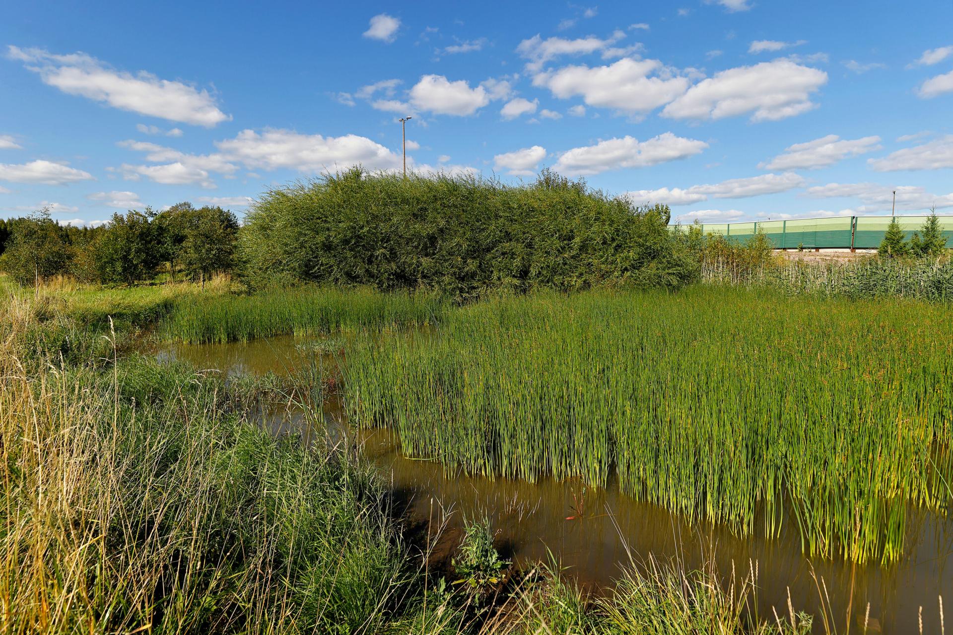
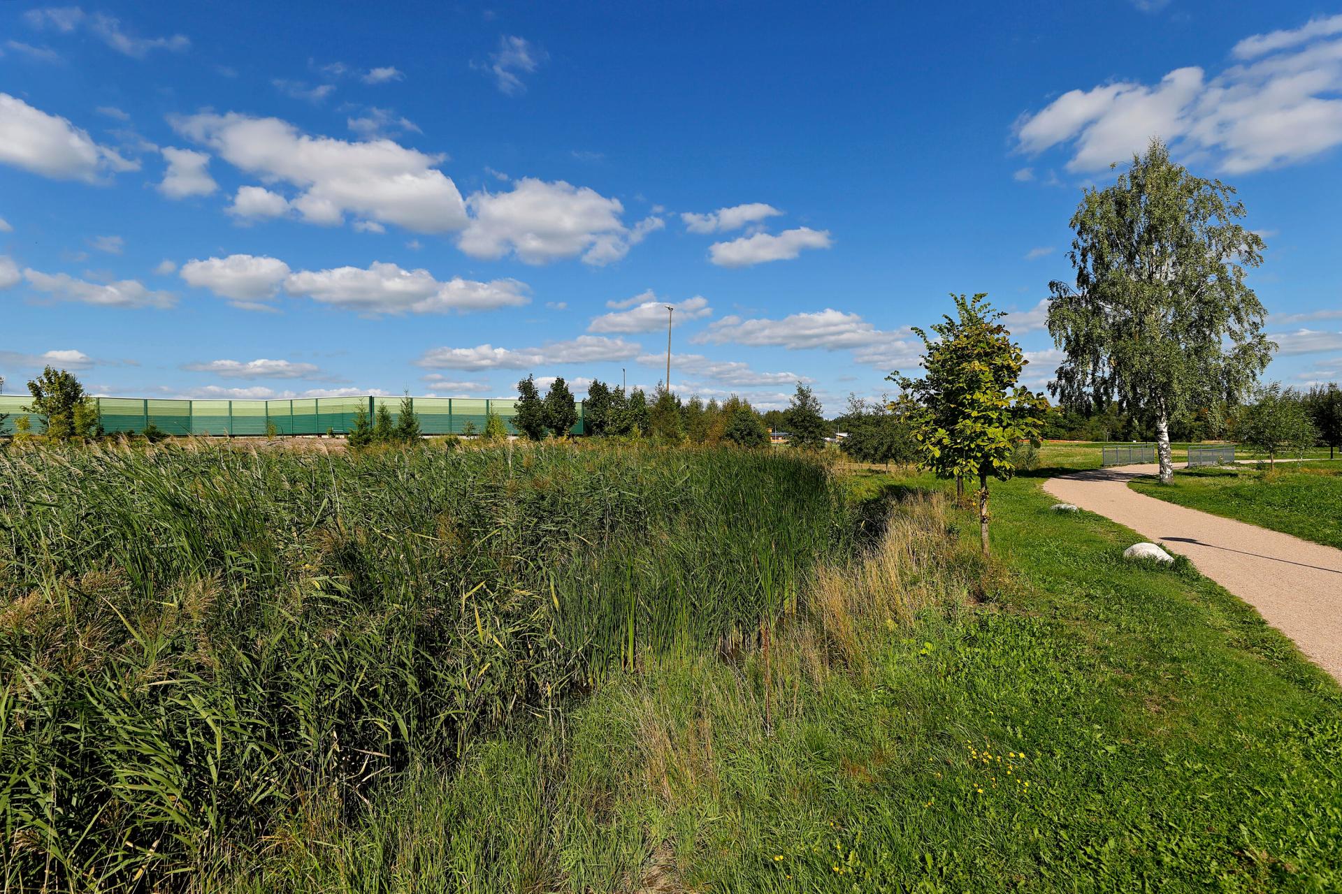
The aim of the Koisotie road's snow reception area's planning process was to establish a wetland area that retains and purifies impurities of the water originating from the snow reception area, and to prevent the load caused by the meltwater in the receiving Kylmäoja stream (see Fig. 29-32). In addition, the purpose was to control the water flow so that a year-round water feature is created in the Tikkurila central park. The wetland area includes a stream on the west side. (Kuntaliitto 2012, Pihlajamaa 2010).
In 2010 it was estimated that the snow reception area receives in an average winter about 5000 truckloads of snow, or about 50000-75000 m3 of snow. This snow contains considerable amounts of impurities that have been considered in the planning phase. The snow stacking area is relatively small considering the drainage area so the treatment of the meltwater and the whole drainage area management have been handled as separate systems. (Siren 2010 cited in Pihlajamaa 2010).
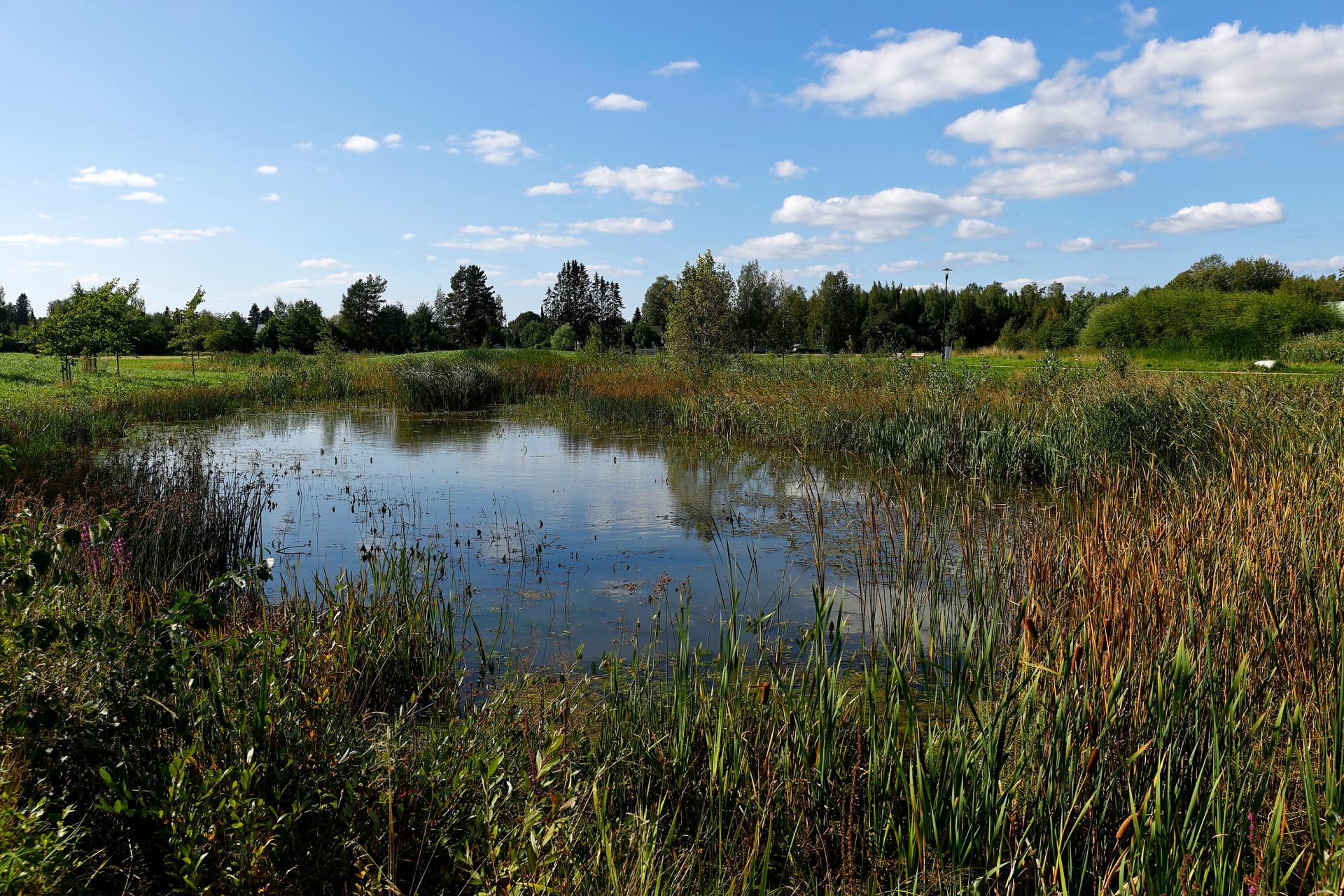
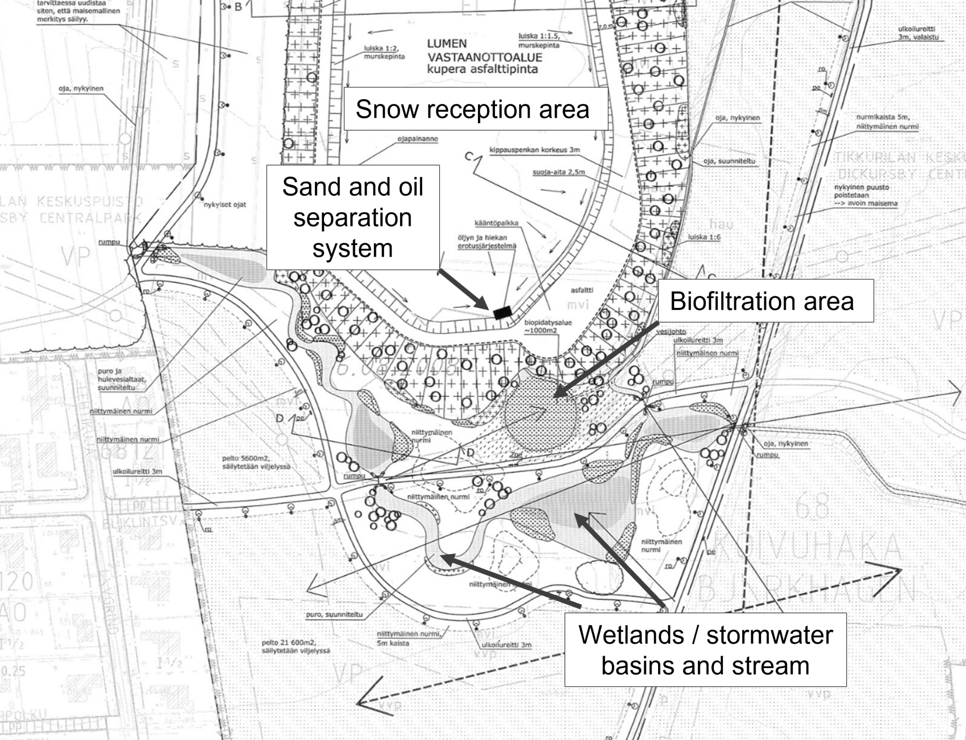
The site is divided into two parts with different characteristics: the actual snow reception area, and its rampart and park area. The park area was built with water features that serve the purposes of cleaning the dirty waters from the snow reception area, and acting as stormwater basins, from which the water flows to the Kylmäoja stream. The water features and plants participating in the purification of the meltwater also enhance the landscape through which outdoor paths are crossing. (Kuntaliitto 2012, Vantaan kaupunki n.d.).
The park includes a biofiltration area that is designed to purify the snow melt water of the reception area. That water is collected via inclinations to the ditches on both sides of the area, and directed to the sand and oil separation system and then onto the biofiltration area. The purpose of the biofiltration area (0,4 m deep basin) is to treat and detain snow reception area’s stormwaters by filtrating them through layers of strata. 90% of the surface area is covered by wetland plants, and those have been selected based on their abilities to withstand both moisture and dry conditions as well as high salt concentrations. The best purification effectiveness is reached when the plant number is high, the number of species does not matter as much. Plants include common reed, common club-rush and narrowleaf cattail. The stormwater that has gone through the biofiltration area (sand, humus, plant base) is directed to the wetland through an underground drain. The water permeability of the biofiltration area filter media needs to be high but it also needs to have the ability to sufficiently retain water and nutrients for the plants. (Kuntaliitto 2012).
Flood plains next to the stream have been planted e.g. meadow plants. Slopes and side of the stream have been planted wetland perennials, mainly domestic natural plants withstanding occasional water level rise. These plant species include European water-plantain, marsh spurge, yellow iris and purple loosestrife. (Kuntaliitto 2012).
The biofiltration area and the wetland appear to have been functioning well. The water outflowing from the biofiltration area has been determined clear(Jormola 2019). Only one water sample is known to have been taken four years ago, to check for heavy metals (Cd, Cu, Pb, Ni ja Zn) of the inflowing and outflowing water in the biofiltration basin. Most of those heavy metals were found to be retained by the biofiltration area. While this test shows in part the structure’s functionality, only a few tests do not yet tell much, says one of the city informants.
According to the maintenance card of the Koisotie site, the yearly monitoring includes checking the condition of the biofiltration basin visually, repairing edges if needed and making sure stormwater can filtrate through. Planted vegetation is also checked in September-October (that it is robust) or in the spring after the snow has melted. Also, the sand and oil trap wells are checked and cleaned. In the long-term maintenance, the vegetation (reeds) is cut back every five years. The subsurface drains are rinsed from sand and the functionality of the biofiltration area is checked, and surface layer is changed as necessary. (Vantaan kaupunki 2018).
Meiramitie road biofiltration swales
Location: Koivuhaka district
Management / system type: detention & infiltration
Land use type: densely built-up
Built: construction works 2013, bioretention areas were finalised in 2014 (Lehikoinen 2015, Vantaan kaupunki 2021b)
Surface area: 210 m2 (Vantaan kaupunki 2021b)
Catchment basin: Kirkonkylänoja stream (Vantaan kaupunki 2021b)
Description:
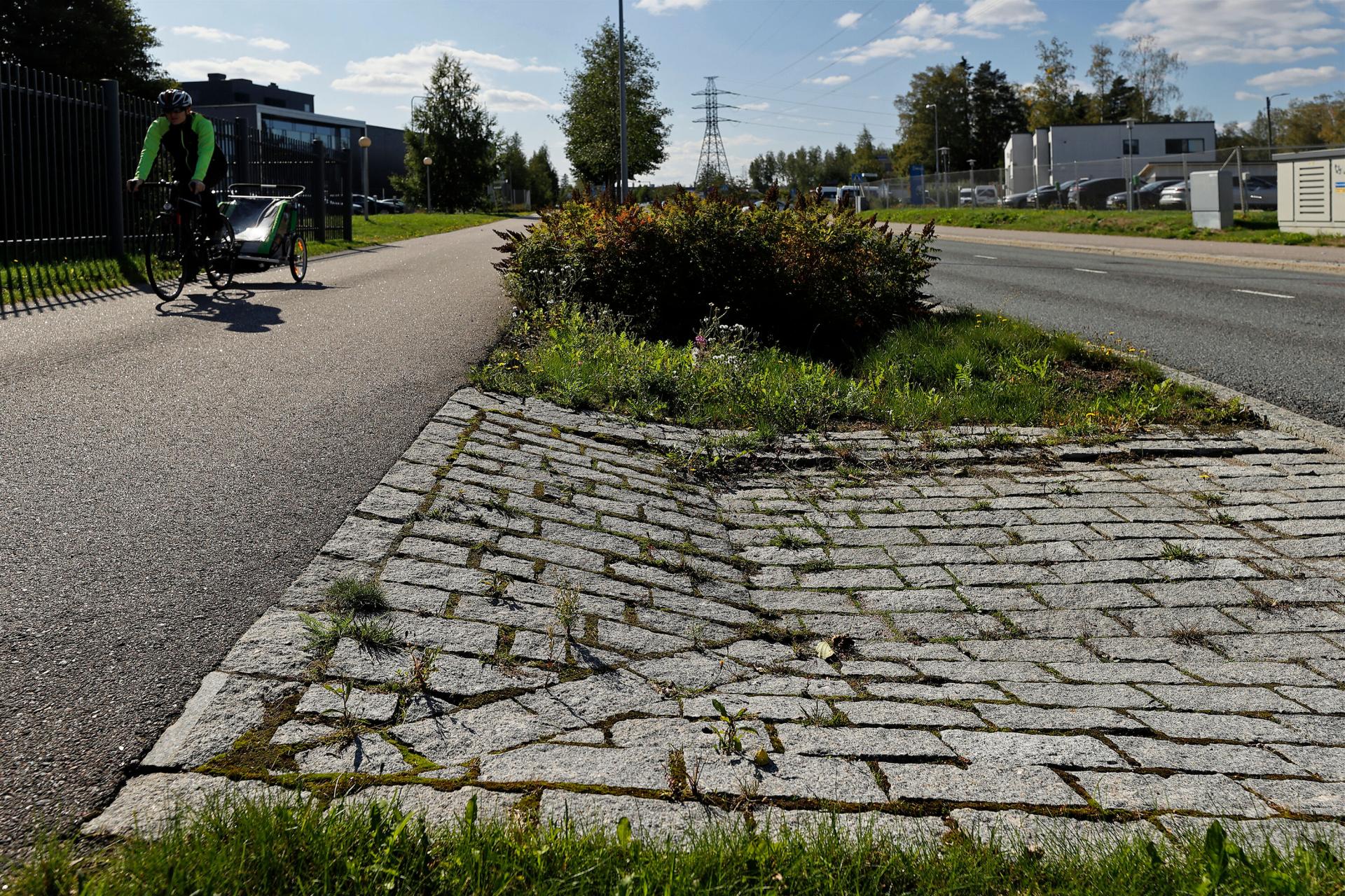
Meiramitie road’s biofiltration or -retention system was built during the road renovation works. Meiramitie is a busy collector road situated in an industrial area and receives both heavy and commuter traffic. The road needed refurbishment e.g. in terms of street structures and stormwater management as the stormwater stood on the street. Five biofiltration areas (or bioswales) and two green areas were built in between the driveway and the pedestrian and bicycle path (see Fig. 33-35). (Ilmastotyökalut.fi 2014, Lehikoinen 2015).
While there are no current traffic numbers, it is estimated to increase: in 2030 the morning peak may see up to 2500 vehicles passing, the evening peak up to 3900 vehicles (Lehikoinen 2015). These traffic numbers are still considered relatively low with regard to impact of traffic on the pollutants, nutrients and chemical oxygen demand (Jokela 2008).
The bioswales receive only half of the road’s stormwater due to the road inclining on both sides. On the south side of the road, stormwaters are directed with road levelling onto the paved depressions retaining the water. On the north side, stormwaters are directed to a stormwater sewer with the shaping of the terrain. (Lehikoinen 2015).
The drainage area of the bioswales consist of stormwaters of the road, pedestrian and bicycle path, roadside and actual biofiltration; also the nearby Niittytie road’s stormwaters are partly directed to Meiramitie road to be treated. Stormwaters are then directed to Kirkonkylänoja stream via Niittytie road’s ditch, and into Keravanjoki and Vantaanjoki rivers. (Lehikoinen 2015).
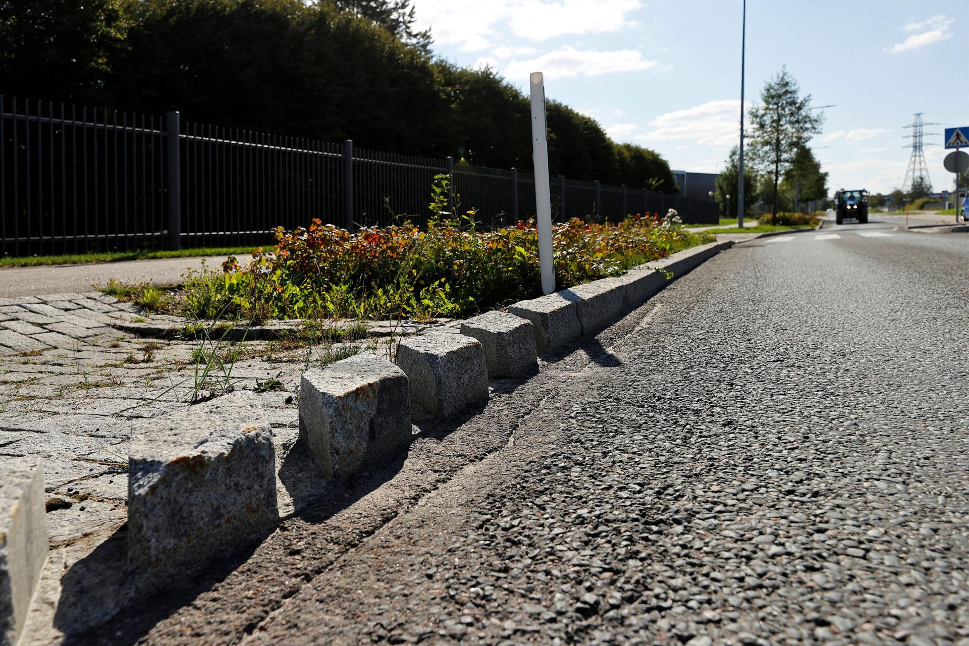
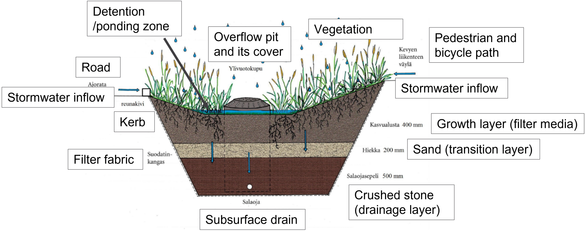
The structure of the bioswales is almost the same in each of them: growth layer on top, then sand, crushed stone and crushed aggregate and the subsurface drain (see Fig. 35). The filter fabric surrounds the whole structure. Stormwaters are directed with road levelling onto the paved depressions retaining the water, which collect the suspended solids and rubbish conveyed with the stormwater. Moreover, two different types of kerb types – zero level and openings in the kerb – were tested to determine which solution directs the stormwater more effectively. For overflows, biofiltration areas were installed covered stormwater pits. The structures are measured to withstand rain lasting for 10 minutes, with an average rainfall intensity of 150 l/s per hectare. (Ilmastotyökalut.fi 2014, Lehikoinen 2015 ).
The bioswales were selected different types of vegetation that are easy to maintain, withstand the scorching sun, road salt and occasionally standing water (lyme grass, skunk currant, meadow foxtail and false spiraea). Tree species selected on the road were common alder (withstanding wet conditions and increasing the nitrogen content of the ground) as well as silver birch and oakleaf mountain ash (thriving in modest, light growing conditions). (Lehikoinen 2015).
Meiramitie road biofiltration area is an example of a stormwater management structure that is a so-called retrofit structure. They have fewer ready instructions compared to some other structures and local conditions strongly impact these types of solutions. (Inkiläinen 2017).
The function and effectiveness of the Meiramitie road bioswales has been investigated by Lehikoinen (2015) and Vahtera and Lahti (2016). It was known that the building phase had already faced issues especially with levelling and that the stormwater was partly flowing to the stormwater sewers instead of the biofiltration areas. Quantity-wise it was found that only a small portion of the driveway stormwaters flowed onto the biofiltration areas especially during light rain events (>17-20mm) due to the small deviations in the kerb (if they were raised or tilted), whereas the pedestrian and bicycle path stormwaters were well directed to and retained by bioswales. (Lehikoinen 2015). In terms of stormwater quality, Vahtera and Lahti (2016) determined based on four samples taken in 2014 and 2015 (in- and outgoing water; rain intensity was not high enough for more samples) that pH and conductivity were higher than other locations studied in Vantaa; the latter was raised by the higher chloride content in winter, most probably due to road salt. With regard to the harmful substances, guideline and threshold values of the stormwater quality classification of Stockholm were used as there are no Finnish equivalents. For instance, PAH compounds were found to be retained in the biofiltration structure while oil hydrocarbons were detected after the structure. (Vahtera and Lahti 2016).
Like in the Koisotie road site, yearly maintenance monitoring visit should include cleaning the paved depressions and biofiltration areas as from sand and rubbish, and checking that the structure works as intended (e.g. no ponding of water is happening). Vegetation needs to be monitored in early autumn (September-October) or after the snow has melted in the spring. In the five-year check, the surface layer of the biofiltration area is renewed, and inspection wells are emptied (or earlier if necessary). (Vantaan kaupunki 2019).
When Lehikoinen (2015) spoke to the maintenance staff, it was found that the stormwater management structures worked mainly well when ploughing snow in winter; however, the ice in the openings of the kerb slowed it down. Those same openings also gathered more leaves and other rubbish compared to the zero edge type of the kerb. Moreover, sanding sand has caused issues as it accumulates in between of the biofiltration area and the pedestrian and bicycle path, gradually preventing the flow of stormwater to the biofiltration area. (Lehikoinen 2105).
While the function of the structure was investigated soon after the installation, and longer-term effectiveness cannot yet be determined, Lehikoinen (2015) proposed some lessons learned as well as solutions. Sanding sand could be stopped with a gravel path where the sand is accumulated. The stormwater could be better directed to the paved depressions if the horizontal alignment of the road was winding and the kerb was slightly lower. The most important proposition nevertheless concerned changing meeting practices to ensure that dialogue with all affected parties continues throughout the process of designing, building, monitoring and maintenance. It was considered essential to document both successes and challenges so that one can learn from them and avoid them in the next site. (Lehikoinen 2015).
It has been recognised that stormwater structures are a visible part of the city, and that informing city dwellers of the stormwater management and related structures is important. Meiramitie road includes an information board that tells about the function of the biofiltration swales. (Ilmastotyökalut.fi 2014).